Zia Pueblo, New Mexico
| Zia Pueblo, New Mexico | |
|---|---|
| CDP | |
|
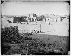
Zia Pueblo in the late 1800s. | |
 Location of Zia Pueblo, New Mexico | |
 Zia Pueblo, New Mexico Location in the United States | |
| Coordinates: 35°30′13″N 106°43′24″W / 35.50361°N 106.72333°WCoordinates: 35°30′13″N 106°43′24″W / 35.50361°N 106.72333°W | |
| Country | United States |
| State | New Mexico |
| County | Sandoval |
| Area | |
| • Total | 27.3 sq mi (70.8 km2) |
| • Land | 27.3 sq mi (70.7 km2) |
| • Water | 0.0 sq mi (0.1 km2) |
| Elevation | 5,472 ft (1,668 m) |
| Population (2000) | |
| • Total | 646 |
| • Density | 23.7/sq mi (9.1/km2) |
| Time zone | Mountain (MST) (UTC-7) |
| • Summer (DST) | MDT (UTC-6) |
| ZIP code | 87053 |
| Area code(s) | 505 |
| FIPS code | 35-86420 |
| GNIS feature ID | 0928840 |
|
Zia Pueblo | |
|
Zia dancer | |
| Nearest city | Zia Pueblo |
|---|---|
| Architectural style | Pueblo |
| NRHP Reference # | 73001146[1] |
| Added to NRHP | April 3, 1973 |

Zia Pueblo (Eastern Keres: Tsi'ya, Spanish: Pueblo de Zía) is a census-designated place (CDP) in Sandoval County, New Mexico, United States. The population was 646 at the 2000 census;[2] Male:310[2] Female:336[2] The pueblo after which the CDP is named is included within the CDP; it is listed on the National Register of Historic Places.[1]
Zia Pueblo is part of the Albuquerque Metropolitan Statistical Area.
Geography

According to the United States Census Bureau, the CDP has a total area of 27.3 square miles (70.8 km²). 27.3 square miles (70.7 km²) of it is land and 0.04 square miles (0.1 km²) of it (0.15%) is water.
Demographics
As of the census[2] of 2000, there were 646 people, 155 households, and 137 families residing in the CDP. The population density was 23.7 people per square mile (9.1/km²). There were 189 housing units at an average density of 6.9 per square mile (2.7/km²). The racial makeup of the CDP was 99.85% Native American, and 0.15% from two or more races. Hispanic of any race were 0.46% of the population.
There were 155 households out of which 43.9% had children under the age of 18 living with them, 43.9% were married couples living together, 37.4% had a female householder with no husband present, and 11.0% were non-families. 10.3% of all households were made up of individuals and 1.3% had someone living alone who was 65 years of age or older. The average household size was 4.17 and the average family size was 4.38.
In the CDP the population was spread out with 34.8% under the age of 18, 12.4% from 18 to 24, 28.5% from 25 to 44, 18.3% from 45 to 64, and 6.0% who were 65 years of age or older. The median age was 27 years. For every 100 females there were 92.3 males. For every 100 females age 18 and over, there were 87.1 males.
The median income for a household in the CDP was $34,583, and the median income for a family was $37,679. Males had a median income of $20,313 versus $19,271 for females. The per capita income for the CDP was $8,689. About 15.0% of families and 15.4% of the population were below the poverty line, including 18.6% of those under age 18 and 9.1% of those age 65 or over.
See also
References
- 1 2 National Park Service (2009-03-13). "National Register Information System". National Register of Historic Places. National Park Service.
- 1 2 3 4 "Zia Pueblo CDP, New Mexico". United States Census Bureau. 2000. Retrieved July 5, 2009.
Further reading
- Sims, Christine P. (1996) Native Language Communities: a descriptive study of two community efforts to preserve their native languages National Indian Policy Center, The George Washington University, Washington. D.C., OCLC 38077755
- Stanley, Francis (1969) The Zia, New Mexico Story no publisher listed, Pep, Texas, OCLC 2776310
- Stevenson, Matilda Coxe (1894) The Sia (extract from the Eleventh Annual Report of the Bureau of Ethnology) Government Printing Office, Washington. D.C., OCLC 968609
- White, Leslie A. (1962) The Pueblo of Sia, New Mexico (U.S. Bureau of American Ethnology, Bulletin 184) Government Printing Office, Washington. D.C., OCLC 1044554; reprinted as White, Leslie A. (1974) Zia: the sun symbol pueblo Calvin Horn Publisher, Albuquerque, OCLC 1655409
External links
 Media related to Zia Pueblo at Wikimedia Commons
- American Southwest, a National Park Service Discover Our Shared Heritage Travel Itinerary
| Reservations | |
|---|---|
| Pueblos | |
| Topics | |
|---|---|
| Lists by states |
|
| Lists by insular areas | |
| Lists by associated states | |
| Other areas | |
| |
Municipalities and communities of Sandoval County, New Mexico, United States | ||
|---|---|---|
| City | 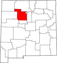 | |
| Towns | ||
| Villages | ||
| CDPs | ||
| Unincorporated community | ||
| Indian reservations | ||
| Footnotes | ‡This populated place also has portions in an adjacent county or counties | |