109 Street, Edmonton

109 Street
Maintained by the City of Edmonton
Length 8.4 km (5.2 mi)
Location Edmonton
South end 52 Avenue
Major
junctions
61 Avenue, Whyte Avenue, Saskatchewan Drive, 97 Avenue, Jasper Avenue, 111 Avenue, Kingsway Avenue
North end Princess Elizabeth Avenue (City Centre Airport)
109 Street, (Garneau Theatre in center).
109 Street leaving the High Level Bridge.

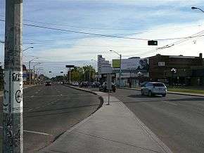
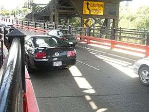
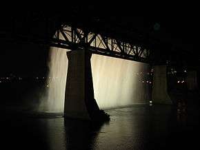
109 Street is an arterial road in central Edmonton, Alberta, Canada. It takes travelers out of Downtown to the south to Old Strathcona, and to the north to the Kingsway area. It passes several Edmonton landmarks including the Garneau Theatre, Alberta Legislature Building, MacEwan University, RCMP "K" Division Headquarters, and Kingsway Mall. It is a one-way street, southbound, from 97 Avenue to Saskatchewan Drive (88 Avenue), to cross the North Saskatchewan River on the narrow High Level Bridge. Before Edmonton's amalgamation with Strathcona in 1912, the Edmonton portion was known as 9 Street.

Neighbourhoods

The High Level Bridge Waterfall

List of neighbourhoods 109 Street runs through, in order from south to north:[1]

Interchanges and intersections

This is a list of major intersections, starting at the south end of Street Name.[1]

Direction Intersecting road Current intersection type Coordinates
South-North 52 Avenue At-grade 53°29′22″N 113°30′43″W / 53.48944°N 113.51194°W / 53.48944; -113.51194 (109 x 52)
57 Avenue At-grade (traffic lights) 53°29′39″N 113°30′43″W / 53.49417°N 113.51194°W / 53.49417; -113.51194 (109 x 57)
61 Avenue At-grade (traffic lights) 53°29′54″N 113°30′43″W / 53.49833°N 113.51194°W / 53.49833; -113.51194 (109 x 61)
65 Avenue At-grade (traffic lights) 53°30′7″N 113°30′43″W / 53.50194°N 113.51194°W / 53.50194; -113.51194 (109 x 65)
72 Avenue At-grade (traffic lights) 53°30′30″N 113°30′43″W / 53.50833°N 113.51194°W / 53.50833; -113.51194 (109 x 72)
76 Avenue At-grade (traffic lights) 53°30′44″N 113°30′43″W / 53.51222°N 113.51194°W / 53.51222; -113.51194 (109 x 76)
University Avenue / 78 Avenue At-grade (traffic lights) 53°30′51″N 113°30′43″W / 53.51417°N 113.51194°W / 53.51417; -113.51194 (109 x University)
Whyte (82) Avenue At-grade (traffic lights) 53°31′5″N 113°30′43″W / 53.51806°N 113.51194°W / 53.51806; -113.51194 (109 x Whyte)
88 Avenue / Walterdale Hill /
Saskatchewan Drive
At-grade (traffic lights) 53°31′26″N 113°30′43″W / 53.52389°N 113.51194°W / 53.52389; -113.51194 (109 x Saskatchewan)
97 Avenue At-grade (traffic lights) 53°32′3″N 113°30′31″W / 53.53417°N 113.50861°W / 53.53417; -113.50861 (109 x 97)
Jasper (101) Avenue At-grade (traffic lights) 53°32′27″N 113°30′30″W / 53.54083°N 113.50833°W / 53.54083; -113.50833 (109 x Jasper)
104 Avenue At-grade (traffic lights) (formerly the "rathole" underpass) 53°32′46″N 113°30′30″W / 53.54611°N 113.50833°W / 53.54611; -113.50833 (109 x 104)
105 Avenue At-grade (traffic lights) 53°32′54″N 113°30′30″W / 53.54833°N 113.50833°W / 53.54833; -113.50833 (109 x 105)
107 Avenue (of Nations) At-grade (traffic lights) 53°33′5″N 113°30′30″W / 53.55139°N 113.50833°W / 53.55139; -113.50833 (109 x 107)
111 Avenue At-grade (traffic lights) 53°33′32″N 113°30′30″W / 53.55889°N 113.50833°W / 53.55889; -113.50833 (109 x 111)
Kingsway (Avenue) At-grade (traffic lights) 53°33′39″N 113°30′30″W / 53.56083°N 113.50833°W / 53.56083; -113.50833 (109 x Kingsway)
Princess Elizabeth Avenue At-grade Y interchange 53°33′51″N 113°30′30″W / 53.56417°N 113.50833°W / 53.56417; -113.50833 (109 x Princess)

References

  1. 1 2 "City of Edmonton map utility". Archived from the original on 2009-06-25. Retrieved 2009-06-23.


This article is issued from Wikipedia - version of the 9/8/2016. The text is available under the Creative Commons Attribution/Share Alike but additional terms may apply for the media files.