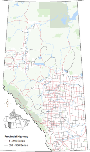
Alberta Highway 627
| ||||
|---|---|---|---|---|
| Township Road 520, Garden Valley Road, Maskêkosihk Trail | ||||
 | ||||
| Route information | ||||
| Maintained by Alberta Transportation | ||||
| Length: | 70 km (40 mi) | |||
| Major junctions | ||||
| West end: | Hwy 759 north of Tomahawk | |||
|
| ||||
| East end: | Winterburn Road, west Edmonton city limits | |||
| Location | ||||
| Specialized and rural municipalities: | Parkland County | |||
| Major cities: | Edmonton | |||
| Highway system | ||||
|
Provincial highways in Alberta
| ||||
Alberta Provincial Highway No. 627[1] is a highway in the province of Alberta, Canada. It runs west-east through rural parts of Parkland County. It begins at Highway 759 about 12 km south of Seba Beach and heads due east until terminating at Winterburn Road. The road continues a short way into Edmonton city limits as Maskêkosihk Trail (/mʌsˈkeɪɡoʊsiː/) to the ring road Anthony Henday Drive at a folded diamond interchange. Portions of 23 Avenue NW and 184 Street NW between Winterburn Road and Anthony Henday Drive were renamed Maskêkosihk Trail in February 2016 to honour Cree heritage.[2][3]
Km by km description
Starting from the west end of Highway 627:
References
- ↑ Provincial Highways Designation Order, Alberta Transportation, p. 20
- ↑ Kent, Fletcher (February 12, 2016). "Portion of Edmonton's 23 Avenue renamed Maskêkosihk Trail". Global News Edmonton. Retrieved February 15, 2016.
- ↑ Neufeld, Lydia (February 12, 2016). "Renamed 'Maskekosihk Trail' part of city's ongoing reconciliation commitment". CBC News. Retrieved February 15, 2016.
External links
- Maskêkosihk Trail – City of Edmonton Naming Committee
This article is issued from Wikipedia - version of the 10/28/2016. The text is available under the Creative Commons Attribution/Share Alike but additional terms may apply for the media files.
