Yellowhead Trail (Edmonton)
| ||||
|---|---|---|---|---|
| Alberta Highway 16 | ||||
 | ||||
| Route information | ||||
| Maintained by City of Edmonton | ||||
| Length: | 24.6 km (15.3 mi) | |||
| Major junctions | ||||
| West end: | 231 Street | |||
|
97 Street Fort Road Victoria Trail | ||||
| East end: |
| |||
| Location | ||||
| Major cities: | Edmonton | |||
| Highway system | ||||
|
Provincial highways in Alberta
| ||||


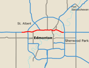
Yellowhead Trail is a major east-west highway in northern Edmonton, Alberta, Canada. The 24.6-kilometre (15.3 mi) segment of Highway 16 is a key commuter route for the bedroom communities of Stony Plain, Spruce Grove, and Sherwood Park. The road is Interchanges already exist at eleven intersections throughout the city limits, but traffic is often jammed at the many intersections still using traffic lights. Edmonton has plans to upgrade Yellowhead Trail to a freeway, but is awaiting required funding from the federal and provincial governments as the project is estimated to cost $1 billion.[1]
Interchanges and intersections
| Hwy | Exit | Intersecting road | Current intersection type | Planned upgrade |
|---|---|---|---|---|
| Continues as | ||||
| Range Road 261 / Hill View Road / 231 Street | At-grade (no crossover) | Interchange planned[2] | ||
| 376 | Winterburn Road (215 Street) | Diamond interchange | ||
| 378 | Cloverstack | |||
| 379 | 184 Street | Folded diamond interchange | ||
| 381 | 170 Street | Diamond interchange | ||
| 383 | 156 Street | Folded diamond interchange | ||
| 151 Street | At-grade (westbound only) | |||
| End Freeway | ||||
| 149 Street | At-grade (traffic lights) | Interchange planned [3] | ||
| 145 Street | At-grade | At-grade (median closure, right turns only)[4] | ||
| 143 Street | At-grade | At-grade (median closure, right turns only)[4] | ||
| 142 Street | At-grade (traffic lights) | Intersection closure[4] | ||
| 385 | Diamond interchange | |||
| 127 Street | At-grade (traffic lights) | Interchange planned [3] | ||
| 124 Street | At-grade (traffic lights) | Intersection closure[4] | ||
| 121 Street | At-grade (traffic lights) | Interchange planned (location to be determined)[3] | ||
| 107 Street | At-grade (traffic lights) | |||
| 389 | Diamond interchange | |||
| 89 Street | At-grade (traffic lights) | Intersection closure[4] | ||
| 391 | 82 Street | Diamond interchange | ||
| 392 | Fort Road / Wayne Gretzky Drive | Single-point urban interchange | Diverging diamond interchange[4] | |
| 68 Street | At-grade | Intersection closure[4] | ||
| 67 Street | At-grade | Intersection closure[4] | ||
| 66 Street | At-grade (traffic lights) | Under review[4] | ||
| 62 Street | At-grade | At-grade (median closure, right turns only)[4] | ||
| Begin Freeway | ||||
| 61 Street | At-grade (westbound only) | |||
| 394 | Diamond interchange | |||
| 396 | Victoria Trail | Folded diamond interchange | ||
| 397 | Hayter Road / 17 Street | Folded diamond interchange | ||
| 398 | Cloverstack interchange | |||
| Continues as | ||||
|
Upgrade under construction • Upgrade planned | ||||
References
- ↑ Dhariwal, Min (September 26, 2016). "Feds and province needed for $1-billion Yellowhead Trail overhaul, says city". CBC News. Archived from the original on September 27, 2016. Retrieved October 23, 2016.
- ↑ Cuthbertson, Lana (July 2, 2011). "Edmonton faces overpass building boom: report". Edmonton Journal. Archived from the original on July 21, 2011. Retrieved October 23, 2016.
- 1 2 3 "Yellowhead Trail Overview Map" (PDF). City of Edmonton. July 13, 2011. Archived from the original (PDF) on September 23, 2012. Retrieved October 23, 2016.
- 1 2 3 4 5 6 7 8 9 10 "Yellowhead Trail Strategic Plan" (PDF). City of Edmonton. May 17, 2011. Archived from the original (PDF) on May 12, 2012. Retrieved October 23, 2016.
This article is issued from Wikipedia - version of the 11/21/2016. The text is available under the Creative Commons Attribution/Share Alike but additional terms may apply for the media files.