1767 Milestones
|
1767 Milestones | |
|
The "Parting Ways" stone in Roxbury | |
| Location | Massachusetts |
|---|---|
| Built | no later than 1767 |
| Architect | Unknown (some erected by Paul Dudley) |
| NRHP Reference # | 71000084, 85003300[1][2] |
| Added to NRHP | April 7, 1971 |
The 1767 Milestones are historic milestones located along the route of the Upper Boston Post Road between the cities of Boston and Springfield in Massachusetts. The 40 surviving milestones were added to the National Register of Historic Places in 1971.[1] Massachusetts has a total of 129 surviving milestones including those along the upper Post Road.[3]
The first stone was erected by Paul Dudley, one of the prominent citizens of early 18th century Massachusetts, in Roxbury, which was at the time a separate community. Roxbury was located at the end of the Boston Neck, a narrow isthmus separating the mainland from the Shawmut Peninsula, where Boston was located. Travelers going by land from Boston to other areas had to travel over the neck and through Roxbury to reach their destinations. The Roxbury junction where Dudley placed the first stone was where several routes branched, heading south and west across New England.
Dudley erected several stones along the road from Boston to Cambridge which wound its way from Beacon Hill along what is now Washington Street through the Dudley Square area to what is now Huntington Avenue, then along Harvard Street through Brookline Village, Coolidge Corner, and Allston crossing into Cambridge at the Great Bridge, where modern JFK Street in Cambridge becomes North Harvard Street in Allston. The stones that Dudley erected have the initial PD on them, usually at the bottom of the stone.[4] The most chatty of these milestones (not part of this collection), is inscribed P Dudley rather than PD, and is located on the corner of Centre and South Streets in Jamaica Plain.
The stones listed for miles 23 through 29 in Wayland and Sudbury are actually guideposts rather than milestones. They do not list any mileage. They were erected at road intersections rather than at the mile marks. The stones are quarried granite posts with plug & feather tool marks and post-date 1800.
| Miles to Boston |
Year Placed |
Image | Location | Town | Notes |
|---|---|---|---|---|---|
| 01 | 1741 |  |
710529Centre and Roxbury Streets 42°19′48″N 71°5′29″W / 42.33000°N 71.09139°W |
Boston, Roxbury | This stone is called the "Parting Ways" Stone. |
| 03 | 1729 | 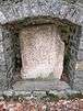 |
710642Centre Street, Fort Hill, Roxbury 42°19′46″N 71°5′36″W / 42.32944°N 71.09333°W |
Boston, Roxbury, Fort Hill | This stone is set in relief along a large stone retaining wall along Centre Street, most likely relocated to this location. |
| 04 | 1729 |  |
710642841 Huntington Avenue 42°19′57″N 71°6′42″W / 42.33250°N 71.11167°W |
Boston, Mission Hill | |
| 05 | 1729 | 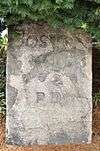 |
710717210 Harvard St. 42°20′24″N 71°7′17″W / 42.34000°N 71.12139°W |
Brookline | |
| 06 | 1729 |  |
710756142 Harvard Ave. 42°21′07″N 71°07′54″W / 42.351947°N 71.131586°W |
Boston, Brighton | |
| 07 | 1729 |  |
710742240 N. Harvard St. 42°21′42″N 71°07′48″W / 42.361556°N 71.129998°W |
Boston, Brighton | |
| 08 | 1734 |  |
710710Old Burial Ground (Mass. Ave. and Garden St.) 42°22′29″N 71°7′10″W / 42.37472°N 71.11944°W |
Cambridge | |
| 23 |  |
712312River Road and Water Row 42°22′14″N 71°23′12″W / 42.37056°N 71.38667°W |
Wayland | ||
| 24 |  |
712408Route 20 and Landham Road 42°21′39″N 71°24′8″W / 42.36083°N 71.40222°W |
Sudbury | ||
| 25 | 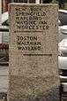 |
712459Route 20 and Concord Road 42°21′44″N 71°24′59″W / 42.36222°N 71.41639°W |
Sudbury | ||
| 26 | 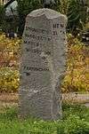 |
712530Route 20 and Nobscot Road 42°21′36″N 71°25′30″W / 42.36000°N 71.42500°W |
Sudbury | ||
| 27 | 712614listed at Boston Post Road and Dudley Road 42°21′36″N 71°26′13″W / 42.360003°N 71.436821°W |
Sudbury | Listed as missing in 2009 state survey. | ||
| 28 |  |
712732Route 20 and Peakham Road 42°21′35″N 71°27′32″W / 42.35972°N 71.45889°W |
Sudbury | ||
| 29 |  |
712819Wayside Inn Road and Dutton Road 42°21′28″N 71°28′19″W / 42.35778°N 71.47194°W |
Sudbury | ||
| 33 |  |
713725143 E. Main St. 42°19′44″N 71°37′25″W / 42.32889°N 71.62361°W |
Northborough | ||
| 35 |  |
714143Boston Post Road and Dean Park 42°17′45″N 71°41′43″W / 42.29583°N 71.69528°W |
Shrewsbury | ||
| 43 |  |
714458West Main St. near I-290 42°17′35″N 71°44′58″W / 42.29306°N 71.74944°W |
Shrewsbury | ||
| 47 | 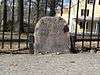 |
714728Lincoln St. 42°16′41″N 71°47′40″W / 42.278071°N 71.794392°W |
Worcester | ||
| 48 | 714759Originally at 139 Salisbury St. 42°15′54″N 71°48′16″W / 42.265051°N 71.804379°W |
Worcester | Moved to 30 Elm Street (Worcester Historical Museum) c. 2007 It was reported to be in storage there in January 2014. | ||
| 53 |  |
715310Route 9 at Collier's Corner 42°14′24″N 71°53′10″W / 42.24000°N 71.88611°W |
Leicester | ||
| 54 |  |
715430Originally at Main St. east of Paxton St. 42°14′43″N 71°54′30″W / 42.24528°N 71.90833°W |
Leicester | Stolen and recovered in the 1990s; relocated to museum space in local library in 1996. An unmarked replica is embedded in a stone wall just west of Paxton on the south side of Main Street. | |
| 56 |  |
715640Between 1676 and 1710 Main St. (Route 9) 42°15′2″N 71°56′40″W / 42.25056°N 71.94444°W |
Leicester | Opposite Leicester Drive-In. | |
| 57 |  |
715721500 Main St. (Route 9) 42°15′21″N 71°57′21″W / 42.25583°N 71.95583°W |
Leicester | In front of the Spencer Country Inn. | |
| 58 |  |
715834 325 Main St. (Route 9) 42°15′6″N 71°58′34″W / 42.25167°N 71.97611°W |
Spencer | ||
| 59 |  |
715920Route 9, Spencer Shopper's Village 42°14′46″N 71°59′20″W / 42.24611°N 71.98889°W |
Spencer | ||
| 60 |  |
720028Route 9 at Dewey St. 42°14′12″N 72°0′28″W / 42.23667°N 72.00778°W |
Spencer | ||
| 61 |  |
720140133 West Main St. (Route 9) 42°13′52″N 72°1′40″W / 42.23111°N 72.02778°W |
Spencer | ||
| 62 |  |
720240west of 324 East Main St. (Route 9) 42°13′38″N 72°2′40″W / 42.22722°N 72.04444°W |
East Brookfield | Stone has been reengraved with loss of integrity. | |
| 63 |  |
720401184 North Brookfield Rd. 42°13′42″N 72°4′1″W / 42.22833°N 72.06694°W |
East Brookfield | ||
| 64 |  |
720445Elm Hill Rd., near North Brookfield line 42°13′49″N 72°4′45″W / 42.23028°N 72.07917°W |
Brookfield | ||
| 65 |  |
720540Elm Hill Rd., east of North Brookfield Rd. 42°13′18″N 72°5′40″W / 42.22167°N 72.09444°W |
Brookfield | ||
| 66 | 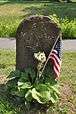 |
720629East of 31 West Main St. (Route 9) 42°12′57″N 72°6′29″W / 42.21583°N 72.10806°W |
Brookfield | ||
| 67 |  |
720714102 Foster Hill Rd. 42°13′33″N 72°7′14″W / 42.22583°N 72.12056°W |
West Brookfield | ||
| 68 |  |
720815East end of town common 42°14′10″N 72°8′15″W / 42.23611°N 72.13750°W |
West Brookfield | ||
| 69 |  |
720922147 West Main St. (Route 9) 42°14′1″N 72°9′22″W / 42.23361°N 72.15611°W |
West Brookfield | ||
| 70 |  |
721022Route 67 near Old Patrick Rd. 42°13′19″N 72°10′22″W / 42.22194°N 72.17278°W |
Warren | ||
| 71 |  |
721059Burbank and Washington Sts. (behind/north side of 129 Washington St.) 42°12′46″N 72°10′59″W / 42.21278°N 72.18306°W |
Warren | ||
| 72 |  |
721122Bemis and Washington Rds. 42°12′7″N 72°11′22″W / 42.20194°N 72.18944°W |
Warren | Now in front of Warren Congregational Church; relocated after 1970. | |
| 73 |  |
721220North side of Baypath Rd. 42°11′53″N 72°12′20″W / 42.19806°N 72.20556°W |
Warren | ||
| 74 |  |
721318970 Read St., east of West Warren Rd. 42°11′9″N 72°13′18″W / 42.18583°N 72.22167°W |
Warren | ||
| 99 | |
723446State Rd. (Route 20) at Springfield Armory 42°6′25″N 72°34′46″W / 42.10694°N 72.57944°W |
Springfield | Now in storage at the Armory Museum. | |
| 999999Source unless otherwise cited: NRHP nomination papers[5] | |||||
References
- 1 2 National Park Service (2008-04-15). "National Register Information System". National Register of Historic Places. National Park Service.
- ↑ first refnum is for all milestones; second is for Brookline, Harvard Avenue stone
- ↑ Gage, Mary E.; Gage, James E. (2014). Milestones & Guideposts of Massachusetts and Southeastern New Hampshire. Amesbury, MA: Powwow River Books. pp. 155–160. ISBN 978-0-9816141-7-5.
- ↑ http://www.jphs.org/colonial/colonial-stones-mark-miles-from-old-roxbury-to-old-state-house.html
- ↑ "NRHP Nomination for 1767 Milestones". Commonwealth of Massachusetts. Retrieved 2011-08-29.
See also
- National Register of Historic Places listings in northern Boston, Massachusetts
- National Register of Historic Places listings in southern Boston, Massachusetts
- National Register of Historic Places listings in Brookline, Massachusetts
- National Register of Historic Places listings in Cambridge, Massachusetts
- National Register of Historic Places listings in Middlesex County, Massachusetts
- National Register of Historic Places listings in Worcester County, Massachusetts
- National Register of Historic Places listings in Hampden County, Massachusetts
| Topics |  | ||||||||||||||||||||||||||||||
|---|---|---|---|---|---|---|---|---|---|---|---|---|---|---|---|---|---|---|---|---|---|---|---|---|---|---|---|---|---|---|---|
| Lists by county | |||||||||||||||||||||||||||||||
| Lists by city |
| ||||||||||||||||||||||||||||||
| Other lists | |||||||||||||||||||||||||||||||
| |||||||||||||||||||||||||||||||