Mission Hill, Boston
|
Mission Hill Triangle Historic District | |
|
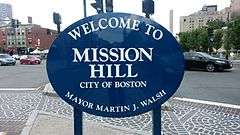
Welcome sign in Brigham Circle intersection, Mission Hill, Boston, near front of Stoneman Plaza, BWH | |
| Location | Boston, MA |
|---|---|
| Architect | Multiple |
| Architectural style | Colonial Revival, Late Victorian |
| NRHP Reference # | 89001747[1] |
| Added to NRHP | November 6, 1989 |
Mission Hill is a ¾ square mile[2] neighborhood of Boston, with the population of over 13,000 in 2008,[3][4][5] nearly 16,000 (15,883) human persons in 2007,[6] and now likely about 19,000,[7] of whom about 3,000 short-term residents are undergraduates from neighboring colleges (or about 16%) and maybe another 1500 are short-term visiting scholars, students, researchers, and degree candidates (or about 8%) working in the adjacent Longwood Medical Area for Harvard Medical School, Harvard T.H. Chan School of Public Health, and/or the Harvard teaching hospitals. Over 32% of residents are in the 20-24 age category, and over 9% are in the 25-29 age category; almost 42% are in their 20s. Indeed, the 2014 American Community Survey published by the City of Boston states that 40.2 percent of the Hill’s population is 18 to 24 years old. One source of this is Mission Hill's residential appeal to college undergraduates and other young people who seek a party atmosphere.[8] The Boston Redevelopment Authority reported in September 2014 that 42.2% of the neighborhood's elderly population lives in poverty.[9]
The neighborhood is roughly bounded by Columbus Avenue and the Boston neighborhood of Roxbury to the east, Ruggles Street to the northeast and the Olmsted designed Riverway/Jamaicaway, and the town of Brookline to the west. The Historic District was designated by the Boston Landmarks Commission in 1985 and is roughly bounded by Smith Street, Worthington Street, Tremont Street (to the south), and Huntington Avenue (to the west). The Mission Hill neighborhood is immediately north of the Boston neighborhood of Jamaica Plain. It is served by the MBTA Green Line E Branch and the Orange Line, and is within walking distance of the Boston Museum of Fine Arts and the Gardner Museum. "The Hill" overlaps with about half of the Longwood Medical and Academic Area, home to 21 health care, research, and education institutions which together provides the largest employment area in the City of Boston outside of downtown. Due to these adjacencies, the neighborhood is often struggling with institutional growth taking residential buildings and occupying storefront commercial space. But recent years have seen new retail stores, restaurants, and residential development giving the neighborhood a stronger political voice and identity, as some of the educational institutions have made commitments to house all or most of their about 2000 undergraduate students in newly erected campus housing, including several new high-rise dormitories. People ages 20 to 24 account for 32% of the population currently living in Mission Hill.
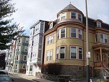
Mission Hill is an architectural landmark district with a combination of freestanding houses built by early wealthy landowners, blocks of traditional brick rowhouses, and many triple-deckers. Many are now condominiums, but there are also several two-family and some single-family homes.
The neighborhood was named in March 2008 as one of 25 "Best ZIP Codes in Massachusetts" by The Boston Globe, citing increased value in single-family homes, plentiful restaurants and shopping, a marked racial diversity, and the behavioral fact that 65% of residents walk, bike, or take public transit to their work.[10]
Geography
The neighborhood has two main commercial streets: Tremont Street and Huntington Avenue. Both have several small restaurants and shops. Mission Hill is at the far western end of Tremont Street, with Government Center at the far eastern end. Mission Hill has two main ZIP codes; the southern half is designated 02120 and the northern area is 02115. Additionally, a very small portion of the southeastern edge uses the code 02130 and two streets on the far western edge use 02215.
Parker Hill, Roxbury Crossing, the Triangle District, Back of The Hill, and Calumet Square are areas within the Mission Hill, an officially designated neighborhood in Boston (as attested by numerous signs prohibiting parking without a suitable Mission Hill neighborhood residential sticker, which only residents can procure legally).
Brigham Circle, located at the corner of Tremont and Huntington is the neighborhood's commercial center, with a grocery store (Stop & Shop), drug stores, bistros, banks, and taverns. Additionally, two other smaller commercial areas are in the neighborhood: Roxbury Crossing and the corner of Huntington and South Huntington next to the Brookline line.
One block up the hill from Brigham Circle is Boston's newest park, Kevin W. Fitzgerald Park (formerly Puddingstone Park)[11][12] created when a new $60-million mixed use building was completed in 2002.
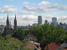
On Tremont Street is Our Lady of Perpetual Help Basilica (1878, Schickel and Ditmars, 1910 towers addition by Franz Joseph Untersee),[13] an eponymous landmark building that dominates the skyline of the area. The church was chosen as the location for the funeral of Senator Edward M. Kennedy on Saturday, August 29, 2009.
Also nearby is the recently restored Parker Hill Library,[14] the neighborhood branch of the Boston Public Library,[15] and designed by architect Ralph Adams Cram in 1929. The city used eminent domain to acquire the land for both the library and the adjacent Mission Hill playground.
Atop the hill are the New England Baptist Hospital and the Parker Hill Playground, which extends from the hospital grounds down Parker Hill Avenue. Parker Hill Playground, originally proposed in 1915 by then Boston Mayor James Curley, is also one of the highest points in the city where one can enjoy a panoramic view of downtown Boston, Boston Harbor, and the Blue Hills.
Always considered a part of Roxbury until a generation ago, Mission Hill is now most often regarded as a conceptually distinct (though not necessarily physically separate) section of the city. However, neighborhood boundaries in Boston are inherently ambiguous, and whether or not Mission Hill is adjacent to Roxbury or remains a section of Roxbury (which it is, according to the City of Boston) is sometimes a subject of vigorous debate.[16]
Green Space
There is a park in Mission Hill that is a walking, sitting park for the community. This park is called the Kevin W. Fitzgerald Park. The park includes lawn space and asphalt walkways for people to walk on. The walkway is lined with benches for people to rest and enjoy the various views such as, Lower Roxbury, the Fenway, and Back Bay. This park was previously one of the 5 quarries in Boston. This park was known as the Harvard Quarry. The operation of the quarry was ceased around the year 1910 and this left a 65 foot high quarry wall. In 1964 Harvard University filled the land in. In the 1990s the open space planning committie worked on preserving public access to the quarry. The community and the developer decided together that the walls of the old quarry would be preserved and they would created a new 6-acre open space for the community at the top of the puddingstone bowl. Harvard Quarry Urban Wild was then named Puddingstone Park. In November 2006, the park was named Kevin Fitzgerald Park in honor of the former Massachusetts State Representative.[17] Most of the open space in Mission Hill is privately or institutionally owned. It will be hard to protect this land from being developed on. Most of the land is already being developed on for more housing and institutional purposes. Only 6.2 acres of land are protected for preservation of public access.[18] McLaughlin Park is another park located in Mission Hill. There was an article posted in the Mission Hill Gazette on April 3 that talked about the park being renovated on a $430,000 budget. A direct quote taken from the article states the plan for the renovations, "The City presented a plan for the renovation in September that would lay a loop path around the upper terrace; build an overlook area along the southeastern portion of the terrace; repair Ben’s Tower; add a new set of stairs from the upper terrace to the lower terrace; and address other maintenance issues." [19] Ben's tower is a memorial for a child named Ben that was from Mission Hill and enjoyed playing in the McLaughlin Park. Ben unfortunately died of cancer.
Demographics
In 2011 it was estimated that Mission Hill, Boston has a population of nearly 16,000 residents. Today, that population is estimated at about 19,000 to 20,000 residents.
According to the American Community Survey, the demography of Mission Hill, Boston
- 47.8% White
- 18.0% Black or African American Alone
- 17.5% Hispanic or Latino
- 14.1% Asian alone
- 1.2% Two or more races
- 1.4% Other
2007-2011 Estimates
According to the American Community Survey, Mission Hill's population was 15,883. 47.8% of the people in the community are white. Black and African Americans made up 18.0% of the population, 17.5% is Hispanic or Latinos, 14.1% of the population is Asian, 1.2% of the population is two or more races, and 1.4% of the population is other.
Population by age
According to the American Community Survey, residents between the ages 20–24 make up most of the population of Mission Hill, Boston. This is due in part to the various colleges in or near the area, and a large number of these students live in the school dormitories located in Mission Hill or in off-campus housing.
| Age | Percent | Age | Percent |
|---|---|---|---|
| Under 5 years | 3.1% | 45 to 49 years | 3.9% |
| 5 to 9 years | 3.2% | 50 to 54 years | 2.7% |
| 10 to 14 years | 4.3% | 55 to 59 years | 3.1% |
| 15 to 17 years | 2.2% | 60 to 64 years | 3.2% |
| 18 and 19 years | 7.9% | 65 to 69 years | 1.8% |
| 20 to 24 years | 32.3% | 70 to 74 years | 2.9% |
| 25 to 29 years | 9.4% | 75 to 79 years | 2.0% |
| 30 to 34 years | 6.0% | 80 to 84 years | 1.4% |
| 35 to 39 years | 4.4% | 85 years and over | 2.4% |
| 40 to 44 years | 3.9% |
History
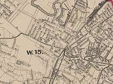
Like the adjacent neighborhood of Jamaica Plain to the south, Mission Hill was once a neighborhood of adjacent Roxbury before Roxbury's annexation by Boston. According to maps from the period, it was often referenced as Parker Hill (which is the name of the geographic feature in the area). After annexation (and more rapidly in recent years) the area slowly came to be considered a separate neighborhood of its own right. The majority of government, commercial and institutional entities list "Mission Hill" in the breakdown of Boston neighborhoods and its boundaries generally agreed upon.
Until the American Revolution, Mission Hill supported large country estates of wealthy Boston families. Much of the area was an orchard farm, originally owned by the Parker family in the 18th century. Peter Parker married Sarah Ruggles, whose family owned large areas of land including most of what became known as Parker Hill (later renamed Mission Hill). His life ended when a barrel of his own cider fell on him. (Much of this story is outlined in "The History of Peter Parker and Sarah Ruggles", a book by John William Linzee, published in 1913.)
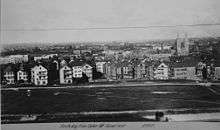
The orchard continued for some time thereafter, but gradually pieces of the land were sold and developed. Boston’s reservoir was once located at the top of the hill. Many of the older apple trees along Fisher Avenue and in an undeveloped area of the playground are probably descendants of the Parker family’s original trees. The lower portion of the eastern hill was a puddingstone quarry with large swaths owned by merchants Franklin G. Dexter, Warren Fisher, and Fredrick Ames.
Maps of the area indicate Mission Hill development began before the Fenway and Longwood Medical Area. Huntington Avenue, now one of the main connections to the rest of Boston, once stopped at the intersection of Parker Street, near the present-day site of the Museum of Fine Arts. Up until that time, Mission Hill was connected via Parker Street (a man-made raised passage between the Stony Brook and the Muddy River - both which formed a tidal flat into the Charles River) all the way to Boylston Street in the Back Bay. Part of what was once Parker Street is now called Hemenway Street. The once main intersection of Parker Street and Huntington Avenue has been traffic-engineered, cutting the straight-line road in two and forcing traffic to first turn onto Forsyth Way to make the connection. Many other streets leading into Mission Hill were also realigned and/or renamed at Huntington Avenue (including Longwood Avenue/McGreevey Way, Smith/Shattuck Street, Vancouver Street, and Palace Road/Worthington Street), limiting both pedestrian and vehicular access.
After the 1880s and the re-routing of the Muddy River by Frederick Law Olmsted, Huntington Avenue was joined from Parker Street to Brigham Circle, creating the Triangle District. (Maps from the time indicate that Huntington Avenue from Brigham Circle to the Brookline line was named Tremont Street.)
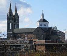
Development began in earnest in the mid-19th century. In 1870, the Redemptorist Fathers built a humble wooden mission church that was replaced by an impressive Roxbury puddingstone structure in 1876. In 1910, dual-spires were added that now dominate the skyline. The church was elevated to basilica in 1954 by Pope Pius XII and is one of only 43 in the United States. Officially named Our Lady of Perpetual Help after the icon of the same name, it is uniformly referred to as "Mission Church", even by its own parishioners. Due to a sloping foundation of this landmark, the west cross tops its tower at 215 feet (66 m); the other spire is two feet shorter. The length of the church is also 215 feet (66 m), presenting a perfect proportion.
At one time, the Basilica was a campus of buildings; the Queen Anne style Sister's Convent and Grammar School (1888–1889, Henry Burns) and the Romanesque Revival St. Alphonsus Hall (1898, Franz Joseph Untersee) administered by the parish. The church closed the high school in 1992, but a Parochial elementary school still remains. The sale of these buildings at 80-100 Smith Street allowed much of the church to be restored. The sold buildings are currently planned for Basilica Court, a 229-unit residential complex, developed by Weston Associates, Inc. The Hall was the club headquarters for the St. Alphonsus Association founded in 1900. It was the preeminent social and athletic Catholic men's organization for nearly 50 years and its 1000-seat theatre held many community, political, and theatrical events.
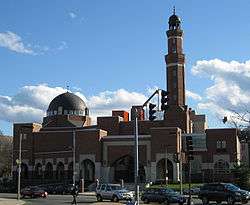
Another example of high religious architecture is the Byzantine-style Annunciation Greek Orthodox Cathedral at 514 Parker Street at the eastern edge of the neighborhood. Referred to as the "mother church" of the Greek Orthodox Church in New England, it is the cathedral of the Diocese of Boston and the seat of its Bishop Methodios. Built between 1892 and 1927, it is one of the oldest Greek churches in the United States, a Boston landmark, and is listed on the National Register of Historic Places. In 1927 a Greek artist was commissioned to decorate the cathedral with Byzantine iconography. The radiant stained glass windows and large crystal chandeliers also contribute to the visual majesty of the cathedral's interior.
Puddingstone plays a historic role in the area. The large puddingstone quarry that ran between Tremont Street and Allegany Street produced the stone foundations of most of the late 19th century houses in the neighborhood. This locally sourced material made quick construction of working-class housing possible. Some structures around the Tremont Street/Parker Street intersection are made entirely of the material, including 682-688 Parker Street, 2-5 Sewall Street and 1472-74 Tremont Street (1856, David Connery, mason).
Most of the houses in the neighborhood are stone foundations and wood construction. But the Triangle Historic District along Huntington Ave. is stone and brick, and one of only eight such districts in Boston given landmark status by the city. These seventy-one buildings bordered by Huntington Avenue, Tremont Street, and Worthington Street exemplify the development of the neighborhood from the 1870s through the 1910s. Construction of this area was begun in 1871. The Helvetia, a distinctive apartment hotel, was built at 706-708 Huntington Avenue in 1884-1885; a Georgian revival apartment building known as The Esther was built at 683 Huntington/142-148 Smith Street in 1912. Both buildings continue have retail on the ground floor and apartments above. Similar row houses line one side of Delle Avenue a few blocks away from the Triangle District. Taller and larger brick row houses also line Huntington Avenue, Wait Street and South Huntington.
By 1894, the electric streetcar was in operation on Huntington Avenue. Builder-developers began cutting streets through the hillside farmland and building homes for commuters on Parker Hill Avenue, Hillside Street, and Alleghany Street. An excellent example from this era is the Timothy Hoxie House at 135 Hillside Street. A freestanding Italianate villa, it was built in 1854 across from its present location. The Hoxie family left Beacon Hill for pastoral Mission Hill. Houses of this size are rare today. Demand for housing went up and builders turned to building multifamily dwellings, generally constructed on smaller lots.
The carpenter-contractor John Cantwell lived in the Gothic Revival cottage at 139 Hillside Street, and purchased the Hoxie House after Timothy’s death. He moved the house to its present site so that upper Sachem Street could be cut through. Cantwell also developed triple deckers on adjacent lots on Darling and Sachem Streets, and in 1890 subdivided the lot on which the Hoxie House stood and built triple-deckers at 17 and 19 Sachem Street.
By the 1890s, there was a more urban feel to the neighborhood and the hill was covered in triple-deckers. Calumet, Iroquois and other streets with Native American names were built up within ten years into a dense neighborhood of triple deckers in the Queen Anne style. The Queen Anne style is prevalent in Mission Hill because this building boom coincided with the popularity of this style. A restoration of this style of houses along Parker Street is becoming something of a Polychrome Row.
Before 1900, the Georgian Revival New England Baptist Hospital (at the time, the Robert Breck Brigham Hospital) at 125 Parker Hill Ave was one of the few institutions in the neighborhood. Other soon followed, moving from their downtown locations to the Mission Hill/Longwood area for more space and less expensive land (along with the completion of the Emerald Necklace). In 1906, the Harvard Medical School moved into five buildings on Longwood Avenue. Wentworth Institute at 360 Ruggles Street began building in 1911. In 1912, the then Peter Bent Brigham Hospital (now Brigham & Women's) opened on Brigham Circle. In 1914, Children's Hospital also moved to Longwood Avenue. Beth Israel Deaconess was constructed a short time later.[20]
In the late 19th century through the 1970s, the neighborhood was once home to large numbers of families of recent Immigrant descent, mostly Irish, but also Germans, Italians and others. After the 1950s, the combined effects of urban renewal, white flight, and institutional growth caused many to flee the neighborhood. In the early 1960s the Boston Redevelopment Authority razed several homes in the Triangle District section of the neighborhood to make way for the Whitney Redevelopment Project, which are three high-rise towers along St. Alphonsus Street. They include Charlesbank Apartments (272 unit co-op), Back Bay Manor (270 units) and Franklin Square Apartments (formerly Back Bay Towers - 146 units). This project was one of Boston's earliest redevelopment projects not funded by federal renewal monies.[20] Across the street is Mission Main, one of the nation's oldest public housing developments. The original thirty-eight 3-story brick structures built between 1938 and 1940 were demolished in the mid-1990s and replaced with 535 new apartments with a mix of subsidized and market-rate units.[21]
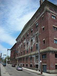
Industry began in the area as early as the 17th century. The first brewery was established at the foot of Parker Hill in the 1820s. By the 1870s beer production was the main industry in Mission Hill, and many breweries lined the Stony Brook (now a culvert running along the Southwest Corridor). Most of Boston's breweries were once located in Mission Hill, but three periods of Prohibition (1852–1868, 1869–1875 and 1918–1933) and the nation's transition from local breweries to national mass-produced brands took their toll on business. Many of the remaining buildings are now being converted into loft condominia.
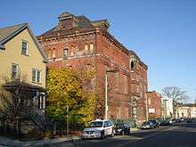
Breweries included A.J. Houghton (1870–1918) at 37 Station Street, American Brewing Co. at 251 Heath Street(1891–1934)—now American Brewery Lofts, Union Brewing Co. on Terrace Street (1893–1911), Roxbury Brewing Co. at 31 Heath Street (1896–1899)—the building is now home to the Family Service of Greater Boston, Croft Brewing Co. (1933–1953), Burkhardt Brewing Co. (1850–1918), Alley Brewing Co. at 117 Heath Street (1886–1918) and the Highland Springs Brewery/Reuter & Co. (1867–1918) on Terrace Street—the building is often referred to as The Pickle Factory and is in planning for conversion to housing.
From 1916 through the early 1950s, Gordon College, related to the Ruggles Street Baptist Church formerly on Ruggles Street, was on Evans Way in the Fenway on the edge of Mission Hill. When Gordon moved out of the neighborhood near the Museum of Fine Arts and relocated to Wenham, Massachusetts, Wentworth Institute of Technology bought the land. The 7-story Alice Heyward Taylor Apartments were completed in 1951;[22] since that time, they have been completely renovated.[23]
In the late 1960s, Harvard University, through straws, thus concealing the purchases from the neighborhood, bought the wood frame and brick houses along Francis, Fenwood, St. Alban's, Kempton Streets, and part of Huntington Avenue, and announced plans to demolish the buildings. Most were replaced with the Mission Park residential complex of towers and townhomes in 1978 after neighborhood residents organized the Roxbury Tenants of Harvard Association to convince Harvard to rebuild. The tower sits on the site of the House of the Good Shepard, once a large and prominent orphanage. The gates to the complex and the brick wall along Huntington survive from this era.
Also in the 1960s the federal government proposed to extend Interstate 95 into the center of Boston and began buying property and demolishing houses in the Roxbury Crossing section of the neighborhood along the Boston and Providence Rail Road. Roxbury Crossing, once known as Pierpoint Village after the Pierpoint family and their mills (the earliest of which in the 1650s), and has been a stop along the Boston & Providence Railroad since the 1840s, was once a vibrant commercial area with the 749-seat Criterion Theatre, a Woolworth's, and some restaurants catering to market tastes.
Though the Interstate project was shelved by the governor in 1971 after freeway revolts, Roxbury Crossing had been leveled. Ten years later saw the creation of the Southwest Corridor, a park system with bike and pedestrian trails that lead into the center of Boston. In November 2007, the MBTA awarded Mission Hill Housing Services rights to develop a new 10-story mixed-use building on what is known to the Boston Redevelopment Authority as "Parcel 25", across from the Roxbury Crossing station.
By the early 1970s, the area was deemed dangerous and most White people and affluent Black people had moved away. The 1989 incident involving Charles Stuart further intensified this view. With property values low, many of the homes were bought by slum lords and converted into rental housing. The inexpensive rents brought many students from nearby colleges and universities, especially MassArt, Northeastern University, Wentworth Institute of Technology and the School of the Museum of Fine Arts, which has a large studio building in the neighborhood.[24] The Mission Hill Artists Collective now hosts Open Studios[25] in the fall of each year.
As past fears faded by the mid-1990s, the area began to change as homeowners moved into newly converted condominia to take advantage of the fantastic views of the city and proximity to the Longwood Area, the MBTA and downtown Boston.
Today, the neighborhood is briskly gentrifying and diversifying in favor of a mix of new luxury condominia and lofts, triple-deckers converted to condominia, surviving student rental units, newly rebuilt public housing, and strong remnants of long-time residents. Racially, Mission Hill is one of the most diverse in the city, with a balance of white, Asian, Hispanic and African-Americans having little conflict along race lines.
Much of the early history of Mission Hill through 1978 is covered in a 65-minute documentary video, Mission Hill and the Miracle of Boston, a widely used documentary which was directed by Richard Broadman (died 2002) of the Museum of Fine Arts and released in 1978. The film recounts the events that led to the Urban Renewal Program in Boston and its aftermath by showing how these events unfolded in Mission Hill.[26]
Current events include the transformation of Terrace Street into an artist boulevard, with new artists' residences in the planning and approval stages. They will take their place along Diablo[27] glass studio and the Building Materials Co-Op. An annual Boston Vegetarian Food Festival at the Reggie Lewis Track and Athletic Center attracts about 8000 visitors in late October or early November.
Current community organizing of hundreds of residents involves broad opposition to a 305-foot 35-story 385-unit residential high-rise at 45 Worthington Street in the Historic Triangle (populated by 3-story historic brownstones), an unprecedented (in Mission Hill) densely packed commercial property that violates existing laws and quality of life standards for the City. The proposal from Equity Residential of Chicago (EQR) is for a 'transit-oriented' property (housing appealing to car-free commuters), since the Huntington Avenue E-Line is within a few yards of the intended site.[28]
The Mosque for the Praising of Allah of the Islamic Society of Boston is in Roxbury Crossing near the Roxbury Community College.
Urban Policy
An article published in the Mission Hill Gazette on April 3, 2015 talks about the potential plans to build a 35 story tower with 395 units. This is a huge project and people are concerned that it is too big of a building for the neighborhood. A Boston Redevelopment Authority Director, Brian Golden, met with neighbors of this potential tower plan. He stated that he did not want this project to affect the family feel of the neighboring streets. In previous years there have been problems with trying to build towers because there are restrictions set, such as, the building can only be a certain height. The BRA is looking into these old redevelopment plans to see if they will affect this potential future project. Golden walked the neighborhood with people who would be potential neighbors of this project and they were able to voice some of their concerns in a respectful manner. The people of the community are concerned that this building will bring more traffic to the area and that the people who move in will "Not participate in the life of the neighborhood." [29]
A second article from the Mission Hill Gazette published one April 3, 2015, "BRA creating 'Avenue of Arts' design guidelines, talks about guidelines used for new developments. A direct quote from the article talks a little about the guidelines expected for future construction, "The guidelines would suggest such aspects as the mass of buildings, pedestrian facilities, and the materials and colors used in construction." There was a meeting held the previous week where members of the public voided that they want these guidelines to extend farther in Mission Hill. I think this is important to note because that means changes will be made to future construction in this area.[30]
According to the American Community Survey, the median household income in Mission Hill is $33,432 during a 12-month span. 21.1% of the households make less than $10,000 yearly. The median family income during a 12-month span is $36,237. The highest percent of family income accounts for 12.0% and they make between $75,000 to $99,999 yearly. Out of 6,230 households 1,300 received food stamps/SNAP over a 12-month span.
Community Resources
- The Tobin Community Center is located at 1481 Tremont Street, Roxbury Massachusetts. This community center is for Mission Hill and other neighborhoods in the area. This center as stated on the Timothy Smith Network is for social, educational, recreational, and cultural purposes. There are thirty-eight Boston Centers for Youth & Families facilities. The Tobin Center provides programing for children, youth, adults, and families. Most of the programming provided is coed, but it requires a membership. The Tobin Community Center is open all seven days of the week. Some but not all of their programming is free, but participating in programs requires a (free) membership.[31][32]
- Mission Hill Main Streets (MHMS) is a non-profit organization that helps rejuvenate local businesses, residents, and community organizations. They provide professional support to businesses on operations and property upkeep. Their recently revised (2014) website lists their goals: "Revitalize the Mission Hill commercial area, Increase merchant participation in the Main Street organization and in the life of the Mission Hill community, Provide Mission Hill merchants with technical assistance and with financial and design assistance for storefront renovations, Reduce negative health impacts – noise, clutter, trash, smells - of how business is done, Continuously improve the appearance, healthfulness, safety, and functionality of the Mission Hill business districts and the Mission Hill host community, Work with schools, students, employee groups, neighborhood organizations, and the local District Courts on community services projects throughout the area." [33] The director, Richard Rouse, a former Suffolk County sheriff, writes a monthly column in the Mission Hill Gazette about neighborhood news and the group's accomplishments. They help small businesses stay presentable and solvent in Mission Hill and support the equitable development of a stable presence in Mission Hill. They provide direct financial help to businesses for physical changes, including design and repairs. Residents can refer businesses for help in making their shops look more appealing.
- The Parker Hill Branch Library of the Boston Public Library is open Monday through Saturday, providing year-round children's programs, often collaborating with the Tobin Community Center, the Mission Hill Health Movement, and Mission Hill Artists Group (displaying work by local artists).[34] From 1968 to 1970, when it was founded (in July 1970), MHHM acted as the Community Health Committee of Parker Hill-Fenway Area Planning Action Committee (APAC), through the local office of the Action for Boston Community Development (ABCD), when it negotiated with the US Department of Health and Human Services and the Harvard Community Health Plan (HCHP) for neighborhood-based coverage by Harvard Community Health Plan. That agreement included the first Medicaid/Medicare HCHP eligibility with sliding scale premiums for Mission Hill residents, and a local primary care outreach/advocacy office with its neighborhood residents in meaningful staff positions. It was instrumental in founding the Fenway Community Health Center. It conducted with neighborhood staff a neighborhood-based door-to-door lead paint testing program and coordinated with the Boston Department of Health and Hospitals (DHH),[35] later (after a series of complex mergers[36] the Boston Public Health Commission, to offer the first neighborhood-based free flu shots for elderly. It helped establish at Hennigan School a preschool program integrating special needs students into mainstream classes and set up for Mission Hill children the "SWISH" school-based dental care program with fluoride rinses, scheduling Mission Hill 'Swish Moms' to work with and assist Harvard Dental School staff.
- Between the Parker Hill Branch Library of the Boston Public Library and Mission Church is Sheehy Park, where young people play, the annual Mission Hill Community Health, Wellness, and Fitness Fair is held in mid-April, and students gather to chat and study after school. That event is cosponsored by Mission Hill Health Movement and MCPHS University.
Healthcare and responsibility for health
The Mission Hill Health Movement is a community-based organization addressing an array of health conditions and other issues of residents of the Mission Hill community and surrounding neighborhoods, such as obesity, diabetes, heart disease, mental illness and depression, exercise and energy levels, personal and social responsibility for health, and access to health care. They sponsors the twice-weekly Mission Hill Farmers markets throughout the months of June to November, the annual community health fair (with MCPHS University) and a summer food fair in September, and low-cost fresh produce and bread distribution, the $2 bag program, with Fair Foods of Dorchester.[37] At the Tuesday and Thursday farmers' markets, local farmers sell their freshly-picked produce. MHHM sponsors several self-help health programs, including a walking group, a Women's Health Group, and a Diabetes Self-Management Group to educate newly diagnosed and current diabetics and pre-diabetics about how to live responsibly with it, to improve overall health and ease the responsibilities of living day-to-day with chronic diabetes. In 2011, the Mission Hill Main Streets, Tobin Community Center, Mission Hill Health Movement, and Sociedad Latina sponsored the first Mission Hill healthy food festival. Longwood- based hospitals, such as Beth Israel Deaconess Medical Center and Boston Children's Hospital, and schools such as MCPHS University (formerly Massachusetts College of Pharmacy and Health Sciences), and the Whittier Street Health Center, tabled at this festival to field questions and distribute informative literature. The Boston Collaborative for Food & Fitness, Boston Vegetarian Society, Cooking Matters, and Sociedad Latina also offered helpful information. Each Spring, the Mission Hill Health Movement sponsors a community health fair, convening 21 local institutions, organizations, and neighborhood businesses during 2011, and now 66 such exhibitors in 2015, providing health information, screening tests, and health-supporting food. They also provide a "FEET FIRST" walk on Thursdays at 10 AM, rain or shine, at 1534 Tremont Street, exploring the colorful and visually interesting Mission Hill neighborhood and contiguous areas, walking through the Fens, the Rose Garden, Jamaica Plain, and back. "Walks will terminate at the Brigham Circle Farmers Market from mid-June until the end of October."[38] A community relations function of Brigham and Women's hospital supports the Mission Hill community, addressing issues of health care, employment, social programs, and services through outreach to schools, housing developments, youth-serving organizations, and other service groups in Mission Hill and elsewhere in Boston. [39]
The mission statement of the Mission Hill Health Movement prioritizes understanding health conditions and long-term outcomes in terms of 'social determinants of health', while many interventionists whom they host in various forums and venues emphasize the roles of individual and social responsibility for health: healthful living and health-supporting diet, smoking cessation, and regular exercise and hygienic living.
Education
The Mission Hill School serves grades Kindergarten through eighth grade. It is a Boston public pilot school. The children range from 3 years old to 14 years old and the school serves around 250 students. This school is located at 20 Child Street in Jamaica Plain. The mission of this school as written on their website is, "The task of public education is to help parents raise youngsters who will maintain and nurture the best habits of a democratic society be smart, caring, strong, resilient, imaginative and thoughtful. It aims at producing youngsters who can live productive, socially useful and personally satisfying lives, while also respecting the rights of all others. The school, as we see it, will help strengthen our commitment to diversity, equity and mutual respect." [40] This school is a public school.
| Educational attainment for population 25 or older | Total | % | Male | % | Female | % |
|---|---|---|---|---|---|---|
| Total Populations | 7,441 | 100% | 3,360 | 100% | 4,081 | 100% |
| Less than High school diploma | 1,240 | 16.7% | 455 | 13.5% | 785 | 19.2% |
| High school graduate/GED/or alternative | 1,787 | 24.0% | 726 | 21.6% | 1,061 | 26.0% |
| Some College | 1,126 | 15.1% | 569 | 16.9% | 557 | 13.6% |
| Associate degree | 418 | 5.6% | 171 | 5.1% | 247 | 6.1% |
| Bachelor's degree or higher | 2,870 | 38.6% | 1,439 | 42.8% | 1,431 | 35.1% |
The table above is an estimation from the American Community Survey during the years of 2007-2011
Notable residents
- Will Blalock, professional NBA Player for the Detroit Pistons
- Arthur V. Curley, director of the Boston Public Library from 1985 to 1996
- John Curran, A Global Threat Bassist
- Joe Mande, Stand-up comedian and writer for Parks and Recreation, former official spokesperson of LaCroix Water. Resided in Mission Hill while attending Emerson College.
- Deborah Meier, founding principal of the Mission Hill School, which was forced to move from its building in Mission Hill to Jamaica Plain in 2012.
- Therese Murray, former and first woman president of the Massachusetts State Legislature[42]
- Carmen Pola, a long-time Latina politician and community activist who was the first Latina to run for statewide office and the first Director of the Office of Constituent Services, a city-wide office formed under Mayor Raymond Flynn[43] and recently has made elder affairs quite visible in Mission Hill.
- Mike Ross, past Boston City Council President (2009–2014), whose district covered Beacon Hill, Back Bay, West End, and Mission Hill[44]
- Aafia Siddiqui Neuroscientist, (alleged Al-Qaeda operative), convicted of assaulting with a deadly weapon and attempting to kill U.S. soldiers and FBI agents.
- Donna Summer, R&B singer
- Maurice Tobin, former Mayor of Boston, governor of Massachusetts, and U.S. Secretary of Labor.
Newspapers
- Mission Hill Gazette
Neighborhood groups
- Alice Heyward Taylor Tenant Task Force (of the 165 units at Alice Heyward Taylor Apartments)[45][46]
- Boston Redevelopment Authority neighborhood site
- Community Alliance of Mission Hill
- Mission Hill Artists Collective
- Mission Hill Health Movement - sponsor of twice-weekly farmers' markets, extremely low cost fresh produce and bread distribution with ($2 bag of produce with Fair Foods of Dorchester[47]), and an annual community health fair in Sheehy Park on Tremont Street, in mid-April[48][49][49][50]
- Mission Hill Main Streets
- Mission Hill Neighborhood Housing Services - developer of Brigham Circle and the Maria Sanchez Senior Building. MHNHS Founder and Director Jim Hoffman resigned his leadership in 2015 after 42 years with MHNHS, which now is led by Patricia Flaherty, who had been the Senior Project Manager.[51][52] MHNHS manages many multi-unit properties in Mission Hill and invites community members to review its work in its annual meeting in the Spring.
- Mission Main Tenant Task Force
- Roxbury Tenants of Harvard
- Sociedad Latina
MBTA subway stops
- On the Green Line "E" Branch:
- On the Orange Line:
The neighborhood is also served by MBTA Bus Route 39 running from Forest Hills in Jamaica Plain past Copley Square to Back Bay Station, and MBTA route #66 running from Dudley Square in Roxbury, through Brookline to Harvard Square in Cambridge. The Urban Ring crosstown route passes through the far eastern corner of the neighborhood along Longwood Avenue and Huntington Avenue.
The #39 bus was referenced in the Kingston Trio's popular 1949 song, Charlie on the MTA.
See also
- Basilica and Shrine of Our Lady of Perpetual Help
- District 8, Boston
- M.T.A. (song)
- National Register of Historic Places listings in southern Boston, Massachusetts
References
- ↑ National Park Service (2007-01-23). "National Register Information System". National Register of Historic Places. National Park Service.
- ↑ dynamic Google-generated map of Mission Hill neighborhood
- ↑ "SELECTED ECONOMIC CHARACTERISTICS 2008-2012 American Community Survey 5-Year Estimates". U.S. Census Bureau. Retrieved 2014-03-19.
- ↑ "ACS DEMOGRAPHIC AND HOUSING ESTIMATES 2008-2012 American Community Survey 5-Year Estimates". U.S. Census Bureau. Retrieved 2014-03-19.
- ↑ "HOUSEHOLDS AND FAMILIES 2008-2012 American Community Survey 5-Year Estimates". U.S. Census Bureau. Retrieved 2014-03-19.
- ↑ Melnik, Mark; Gao, Lingshan; Kalevich, Alexis; Wong, Joanne. "American Community Survey 2007-2001:Mission Hill". Boston Redevelopment Authority. American Community Survey. Retrieved 2015-03-11.
- ↑ Mission Hill Neighborhood Housing Services (MHNHS), About Mission Hill, accessed 2/23/2015)
- ↑ "Why Some Residential Neighborhoods Are Writing Off Student Renters" by Olivia Vanni, Education, BostonInno, 2/22/16 @5:28pm
- ↑ [Boston Redevelopment Authority, Research Division. Boston’s Elderly, September 2014]
- ↑ http://www.boston.com/realestate/news/articles/2008/03/16/the_best_zip_codes/
- ↑ Mission Hill NHS. Puddingstone Park
- ↑ The Church's own web site
- ↑ The Mission Church
- ↑ Parker Hill Branch Library
- ↑ Boston Public Library
- ↑ Strong arguments for both viewpoints have been presented at Talk:Mission Hill, Boston, Massachusetts. Accompanying this discussion are links to internal sources indicating that other sections of Boston are also subjects of similar debate. Zip codes, electoral zoning, naming of police stations, parking stickers, and myriad other indicators of place have been brought forth as evidence for both sides of the argument. Ultimately, the neighborhoods of Boston have no consistent official status, and the point, taken either way, may be moot.
- ↑ Boston Region Upcoming Events | The Trustees
- ↑ 3i.jamp150.pm
- ↑ McLaughlin Park renovation is out to bid | Mission Hill Gazette
- 1 2 "Mission Hill: background information and planning issues, preliminary neighborhood improvement strategies", Boston Redevelopment Authority, (1975)
- ↑ Mission Main photographic archive of the Boston Housing Authority
- ↑ Alice Heyward Taylor B&W photo archive from Boston Housing Authority
- ↑ Boston Housing Authority information page on Alice Heyward Taylor Apartments
- ↑ Mission Hill Building Project SMFA
- ↑ Boston Open Studios Coalition
- ↑ Richard Broadman Filmmaker Profile Page at Documentary Educational Resources
- ↑ Diable Glass and Metal
- ↑ Photos and online discussion of 35-story, 385-unit Mission Hill smoke-free residential high-rise at 45 Worthington Street
- ↑ BRA head meets with tower neighbors | Mission Hill Gazette
- ↑ BRA creating ‘Avenue of Arts’ design guidelines | Mission Hill Gazette
- ↑ Tobin Community Center. Tobin Community Center http://tobincommunitycenter.org. Retrieved 2015-04-15. Missing or empty
|title=(help) - ↑ Timothy Smith Network http://www.timothysmithnetwork.org/node/990498. Retrieved 2015-04-15. Missing or empty
|title=(help) - ↑ "Mission Hill Main Streets". Mission Hill Main Streets. Mission Hill Main Streets. Retrieved 22 April 2015.
- ↑ Boston Public Library. Boston Public Library https://www.bpl.org/branches/parker.htm. Retrieved 22 April 2015. Missing or empty
|title=(help) - ↑ Boston's Department of Health and Hospitals. Editorial, N Engl J Med 1966; 274:687-689. March 24, 1966. DOI: 10.1056/NEJM196603242741211 Accessed 9/16/2016
- ↑ Boston (Mass.). Board of Health and Hospitals. Boston Public Health Commission Board records by Boston Public Health Commission in English and held by 1 WorldCat member library worldwide
- ↑ Schedule of $2 bag distribution sites throughout Greater Boston
- ↑ Programs - Mission Hill Health Movement
- ↑ Mission Hill Community Programs | Brigham and Women’s Hospital
- ↑ Mission | Mission Hill K-8 School
- ↑ American Community Survey 2007-2011 Estimate
- ↑ Therese Murray at Mass.gov
- ↑ "Biographical Note." Archives and Special Collections Finding Aids: Carmen Pola. Northeastern University Libraries, Archives and Special Collections. Web. Accessed 03 March 2014.
- ↑ City of Boston City Council
- ↑ Alice Heyward Taylor Tenant Task Force, company # 000443130 incorporated 07.10.1993
- ↑ Wentworth Institute of Technology Community Task Force Meeting, June 19, 2013, involving a representative from the Alice Heyward Taylor Tenant Task Force
- ↑ Two Dollar-A-Bag Sites - Fair Foods
- ↑ Event announcement for 2015 Mission Hill Community Health Fair
- 1 2 Event announcement for 2015 Mission Hill Community Health Fair
- ↑ Event announcement for 2015 Mission Hill Community Health Fair
- ↑ LinkedIn profile for Patricia Flaherty
- ↑ Wheaton College (Norton, Massachusetts) May 5, 2013 profile of Patricia Flaherty '83, who was their 2013 Commencement speaker
External links
| Wikimedia Commons has media related to Mission Hill, Boston. |
- The Sociedad Latina, Inc. records, 1968–2007 (bulk 1985–1999) are located in the Northeastern University Libraries, Archives and Special Collections Department, Boston, MA.
- The Carmen A. Pola papers, 1970–2006 (bulk 1975–2000) are located in the Northeastern University Libraries, Archives and Special Collections Department, Boston, MA.
- An early planning study, Fenway-Parker Hill area: its problems and potential, Boston, Massachusetts: preliminary report of the Sponsors’ Committee, is available at the MIT or Harvard libraries, Cambridge, MA.
- Archived papers from the development of the Charlesbank Apartments, 650 Huntington Avenue, are stored in boxes in Harvard Graduate School of Design (GSD) in Harvard Square, Cambridge, MA. Ground was broken in 1960 for three 24-story multi-unit residential highrises, but redesign of two of the three buildings was forced by residents protesting the height; only Charlesbank is 24 stories high.
- City of Boston, Landmarks Commission. Mission Hill Triangle Architectural Conservation District, 1985

Coordinates: 42°20′00.32″N 71°06′27.64″W / 42.3334222°N 71.1076778°W