Abbaretz
| Abbaretz | ||
|---|---|---|
|
Old House converted to Le Manoir de la Jahotiere Hotel at Abbaretz | ||
| ||
 Abbaretz | ||
|
Location within Pays de la Loire region  Abbaretz | ||
| Coordinates: 47°33′12″N 1°31′50″W / 47.5533°N 1.5306°WCoordinates: 47°33′12″N 1°31′50″W / 47.5533°N 1.5306°W | ||
| Country | France | |
| Region | Pays de la Loire | |
| Department | Loire-Atlantique | |
| Arrondissement | Châteaubriant | |
| Canton | Nozay | |
| Intercommunality | Région de Nozay | |
| Government | ||
| • Mayor (2008–2020) | Jean-Pierre Possoz | |
| Area1 | 61.76 km2 (23.85 sq mi) | |
| Population (2010)2 | 1,916 | |
| • Density | 31/km2 (80/sq mi) | |
| Time zone | CET (UTC+1) | |
| • Summer (DST) | CEST (UTC+2) | |
| INSEE/Postal code | 44001 / 44170 | |
| Elevation | 26–91 m (85–299 ft) | |
|
1 French Land Register data, which excludes lakes, ponds, glaciers > 1 km² (0.386 sq mi or 247 acres) and river estuaries. 2 Population without double counting: residents of multiple communes (e.g., students and military personnel) only counted once. | ||
_-_Abbaretz.jpg)
Abbaretz (Abarrez in Breton) is a French commune in the Loire-Atlantique department in the Pays de la Loire region of western France.
The inhabitants of the commune are known as Abbarois or Abbaroises.[1]
Geography
Abbaretz is located 20 km south-west of Châteaubriant and 20 km north-east of Blain. Access to the commune is by the D2 road from Nozay in the west passing through the village and continuing east to La Meilleraye-de-Bretagne. The D1 road comes from Treffieux in the north passing through the village and continuing south. The D35 road comes from Issé in the north-east passing through the village and continuing south-west to Puceul. The D24 road branches from the D1 just south of the village and goes south-east to Joué-sur-Erdre. The D69 road from Issé to Nort-sur-Erdre passes through the east of the commune. Apart from the village there are also the hamlets of:[2]
- Les Breils-Clement
- La Chauvelaie
- La Chauvelais
- Le Chene Trouy
- Coulouine
- La Gleminiere
- La Godardais
- La Hazardiere
- Le Houx
- Le Maffay
- La Placiere
- La Rainais
- La Riviere
- Rozay
- Villeneuve
Neighbouring Communes and Villages[2]
 |
Jans | Treffieux | Issé | |
| Nozay | |
La Meilleraye-de-Bretagne | ||
| ||||
| | ||||
| Puceul | Nort-sur-Erdre | Joué-sur-Erdre |
Toponymy
Abbaretz has been previously known by the following names:
- Abbaretiacum (1123)
- Abbaret (1230)
- Abbarez (1270 and 1278)
- Abbarrez (1341)
- Abbaretz (1456)
- Abbaret (1489)
- La Baretz (1539)
- Abbareium (1650)
- Abbaretz (today).
The name Abbaretz originates from the Gallo language which is the language of Upper Brittany: Abarèt in Gallo (as per ELG)[3]
History
Until the 8th century the parish of Abbaretiacum had its own Lord Bishop under the Bishops of Nantes. Following the invasion of Normandy and civil wars in Brittany in the 11th and 12th centuries Abbaretz ceased to be a feudal state. During the 10th century the lords of Chateaubriand took effective possession of the territory of Abbaretz: to enter Abbaretz was a privilege they gave to one of their younger sons, known by the name of Le Boeuf who was First Lord of Nozay and Issé. In 1123, however, the Duke Conan confirmed the church of Nantes as the owner of the church at Abbaretz.
In June 1230 Brient Le Boeuf, called "The Old Man", Lord of Issé, donated to the Cistercian Abbey of Notre Dame de Melleray, for the salvation of his soul, some land he owned at Abbaretz. The monks of this monastery built a barn and a chapel dedicated to St. Margaret. At the same time, Geoffroy de Trent abandoned his portion of Melleray Abbey and two-thirds of all the tithes of the land of the Abbaretz forest ("decimas terre sue de foresta de Abbaret").
In 1242, Guégon Le Gruc and his wife Agathe of Trent (daughter of Olivier and niece of Geoffroy of Trent) confirmed this pious donation. The parishioners of Abbaretz tried to oppose the increase in their tithes by the monks at Melleray. From the documents in the process, it can be seen that the area called the Forest of Abbaretz was inhabited in 1235 by Daniel and Bernard de Rozé, Guy Lague, Robin Daniel, Guillaume Robin, Riwallon Le Duc, Guillaume Robert, Pierre Constanz, Geffroy Grimaut, Guillaume Raffrey, and Judicaël Troynel who were all vassals of Geoffroy Trent.
When the diocese of Nantes was divided into archdeaconries and deaneries, the parish of Abbaretz was included in the deanery of Chateaubriand, a member of the archdeaconry of Mee.
The fiefs component of the Lordship of Abbaretz was composed of several parts:
- the income from Nozay[Note 1]
- the income from Issé[Note 2]
- the income from Vioreau[Note 3]
- the barony of Derval,
- The Melleray Abbey[Note 4]
The headquarters of the most important Lordship was located at the Chateau de La Riviere which originally belongs to the Briant (or Brient) family and then passed into the hands of the lords of Chateaubriant, then the House of Montmorency, and then the Prince of Condé.
Heraldry
.svg.png) |
The ermine evokes the emblem of Brittany, recalling past inclusion of the town with the Duchy of Brittany. The arms were designed by Mr. Le Rossignol and have been in use since 1983.
Blazon: |
Administration
List of Successive Mayors of Abbaretz[4]
| From | To | Name | Party | Position |
|---|---|---|---|---|
| 1843 | René Suraud | |||
| 1870 | 1871 | François Marchand | ||
| 1871 | 1891 | Julien Bauchene | ||
| 1891 | 1904 | Pierre Herbert | ||
| 1904 | 1937 | Yvonnis Guillotin | ||
| 1937 | 1971 | Jean Brehier | ||
| 1971 | 1989 | Maurice Cadot | ||
| 1989 | 2008 | Robert Bommé | ||
| 2008 | 2020 | Jean-Pierre Possoz |
(Not all data is known)
Demography
According to the classification established by the INSEE, Abbaretz is a commune which forms part of the crown of a large urban pole projecting from the urban area of Nantes[5] to the urban area of Nantes-Saint-Nazaire.[6]
Demographic Change
In 2010 the town had 1,916 inhabitants. The evolution of the number of inhabitants is known through the population censuses conducted in the town since 1793. From the 21st century a census of municipalities with fewer than 10,000 inhabitants is held every five years, unlike larger towns that have a sample survey every year.[Note 5] [Note 6]
| 1793 | 1800 | 1806 | 1821 | 1831 | 1836 | 1841 | 1846 | 1851 |
|---|---|---|---|---|---|---|---|---|
| 1,135 | 829 | 1,266 | 1,505 | 1,671 | 1,729 | 1,814 | 2,274 | 2,363 |
| 1856 | 1861 | 1866 | 1872 | 1876 | 1881 | 1886 | 1891 | 1896 |
|---|---|---|---|---|---|---|---|---|
| 2,454 | 2,293 | 2,623 | 2,694 | 2,727 | 2,693 | 2,706 | 2,775 | 2,803 |
| 1901 | 1906 | 1911 | 1921 | 1926 | 1931 | 1936 | 1946 | 1954 |
|---|---|---|---|---|---|---|---|---|
| 2,732 | 2,730 | 2,763 | 2,523 | 2,392 | 2,345 | 2,277 | 2,087 | 2,183 |
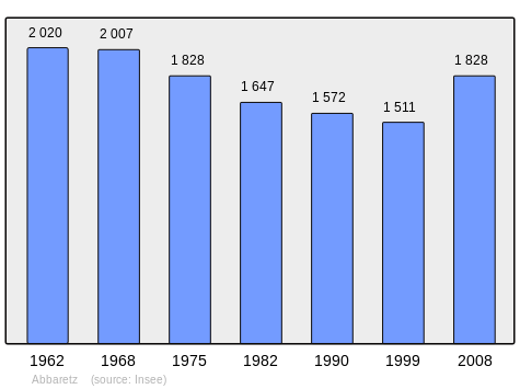
| 1962 | 1968 | 1975 | 1982 | 1990 | 1999 | 2005 | 2006 | 2010 |
|---|---|---|---|---|---|---|---|---|
| 2,020 | 2,007 | 1,828 | 1,647 | 1,572 | 1,509 | 1,711 | 1,747 | 1,916 |
Sources : Ldh/EHESS/Cassini until 1962, INSEE database from 1968 (population without double counting and municipal population from 2006)
Distribution of Age Groups
Percentage Distribution of Age Groups in Abbaretz and Loire-Atlantique Department
| Abbaretz | Abbaretz | Loire-A | Loire-A | |
|---|---|---|---|---|
| Age Range | Men | Women | Men | Women |
| 0 to 14 Years | 23.8 | 25.7 | 20.5 | 18.3 |
| 15 to 29 Years | 16.3 | 14.4 | 20.1 | 18.5 |
| 30 to 44 Years | 23.7 | 21.8 | 21.3 | 20.1 |
| 45 to 59 Years | 17.7 | 16.4 | 20.1 | 19.7 |
| 60 to 74 Years | 12.0 | 11.4 | 12.1 | 13.4 |
| 75 to 89 Years | 6.1 | 9.4 | 5.6 | 9.1 |
| 90 Years+ | 0.3 | 0.8 | 0.3 | 1.0 |
Languages
French and the local language of Gallo are spoken in the area. The Gallo language is in danger of extinction according to a study by Serge Jouin in his thesis: "The Gallo speech of Abbaretz and elsewhere ...", published in two volumes in 1982 and 1984. Abbaretz is also a point of survey for the linguistic atlas (ALBRAM) by Messrs. Guillaume and Chauveau.
Sights and Monuments

- Site of the tin mine. The area was known for its tin production into the 1960s but it has now been converted to recreational purposes.
- The lake that was produced from tin extraction has an area of 15 hectares and is used for water skiing.
- The slag heap is 121 metres high (which is 5 metres higher than the highest hill in the department - Breteche hill) provides a scenic view with hiking and para-sailing opportunities.
- Chestnut tree of the Nonneries: this is a classified tree 800 years old.
- Old Forges of the Jahotière which has now been converted into a hotel and function centre.
 [7]
[7] - The parish Church of Saint-Pierre has a Chalice which is registered as an historical object.
 [8]
[8]
-

The slag heap of the old tin mine.
-
.jpg)
The top of the slag heap.
-
_-_Abbaretz.jpg)
Ruins of the old forge.
-
_-_Abbaretz.jpg)
Old forge building at Jahotière.
-
_-_Abbaretz.jpg)
Buildings at the old forge at Jahotière.
See also
- Communes of the Loire-Atlantique department
- Abbaretz commune website (French)
- The bordering communes of Abbaretz
- Abbaretz on Lion 1906
- Abbaretz on Géoportail, National Geographic Institute (IGN) website (French)
- Abbaretz on the 1750 Cassini Map
- Abbaretz on the INSEE website (French)
- INSEE (French)
Notes and references
Notes
- ↑ (fiefs of Fief-Racaud or Fief-Rouzay, la Hardière, la Gueffraye, la Houssaye, la Rouaudière, les Hauts-Chemins, Galhard, la Pierre, la Chaussee, la Rabardière, Montbaron, Coulouine, la Guilminière, la Bonnaudière, les Rivières, Maffay, la Belaudaye, la Chevrollière, la Pommeraye, la Mollière, la Vennerie, la Placière, la Pourprise, Guillote-Ouairie, la Fouaye, la Forest, Pillet-Morel, Bouzay, Bourdon, Chesne-Trouit, la Chesnaye, la Raimbaudière, la Rabaudière, Rebuffé, Tournel de Hameline, Helland, le bourg d'Abbaretz, etc.)
- ↑ (fiefs de la Minière, du Houx, de la Trahannière, de la Herminière et de la Torraye, ...)
- ↑ (fiefs de la Liraye, d'Estival et de la Bouchetière, ...)
- ↑ (the Barn Abbaretz, the farms of Sainte-Marguerite and Féchetaye the Guichardaye the Rouaudière the Herminière ...)
- ↑ At the beginning of the 21st century, the methods of identification have been modified by law No. 2002-276 of 27 February 2002 , the so-called "law of local democracy" and in particular Title V "census operations" which allow, after a transitional period running from 2004 to 2008, the annual publication of the legal population of the different French administrative districts. For municipalities with a population greater than 10,000 inhabitants, a sample survey is conducted annually, the entire territory of these municipalities is taken into account at the end of the period of five years. The first "legal population" after 1999 under this new law came into force on 1 January 2009 and was based on the census of 2006.
- ↑ In the census table, by convention in Wikipedia, and to allow a fair comparison between five yearly censuses, the principle has been retained for subsequent legal populations since 1999 displayed in the census table that shows populations for the years 2006, 2011, 2016, etc., as well as the latest legal population published by INSEE
References
- ↑ Inhabitants of Loire-Atlantique (French)
- 1 2 Google Maps
- ↑ Breton Towns, Gallo Names, ed. Geobreizh, consulted on 18 March 2013 Archived April 26, 2013, at the Wayback Machine.
- ↑ List of Mayors of France (French)
- ↑ Zonage in the Urban Area of Nantes 2010 (008), insee.fr, ed. INSEE, consulted on 26 December 2012
- ↑ Thematic Map, Ed. INSEE, consulted on 26 December 2012; Go to: on the small map of France, tab to Départements, then click on the département, then from the drop-down menu: Thème - critère - indicateur principal (territoire - organisation territoriale).
- ↑ Ministry of Culture, Mérimée PA00108561 Old Forges of the Jahotière (French)
- ↑ Ministry of Culture, Palissy PM44000001 Statue: (French)
| Wikimedia Commons has media related to Abbaretz. |