Ada, Minnesota
| Ada, Minnesota | |
|---|---|
| City | |
|
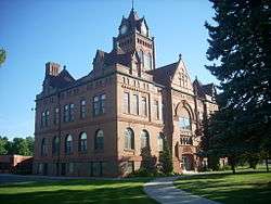
Norman County Courthouse, Ada, Minnesota | |
| Nickname(s): "Heart of the Valley" | |
| Motto: Alive and Thriving! | |
 Location of Ada within Norman County and state of Minnesota | |
| Coordinates: 47°17′55″N 96°30′57″W / 47.29861°N 96.51583°W | |
| Country | United States |
| State | Minnesota |
| County | Norman |
| Government | |
| • Mayor | Jim Ellefson |
| Area[1] | |
| • Total | 1.39 sq mi (3.60 km2) |
| • Land | 1.39 sq mi (3.60 km2) |
| • Water | 0 sq mi (0 km2) |
| Elevation | 906 ft (276 m) |
| Population (2010)[2] | |
| • Total | 1,707 |
| • Estimate (2013[3]) | 1,647 |
| • Density | 1,228.1/sq mi (474.2/km2) |
| Time zone | Central (CST) (UTC-6) |
| • Summer (DST) | CDT (UTC-5) |
| ZIP code | 56510 |
| Area code(s) | 218 |
| FIPS code | 27-00172 |
| GNIS feature ID | 0639200[4] |
| Website | www.adamn.gov |
Ada (/ˈeɪdə/ AY-də) is a city in Norman County, Minnesota, United States. The population was 1,707 at the 2010 census.[5] It is the county seat.[6]
Minnesota State Highways 9 and 200 are two of the main routes in the city.
History
Ada was laid out in 1874.[7] The town was named for the eldest daughter of William H. Fisher, attorney and superintendent of the Saint Paul and Pacific Railroad, who had died aged 6.[7] A post office has been in operation at Ada since 1876.[8] Ada was incorporated in 1881.[7]
Geography
According to the United States Census Bureau, the city has a total area of 1.39 square miles (3.60 km2), all of it land.[1]
Demographics
| Historical population | |||
|---|---|---|---|
| Census | Pop. | %± | |
| 1880 | 138 | — | |
| 1890 | 622 | 350.7% | |
| 1900 | 1,253 | 101.4% | |
| 1910 | 1,432 | 14.3% | |
| 1920 | 1,411 | −1.5% | |
| 1930 | 1,285 | −8.9% | |
| 1940 | 1,938 | 50.8% | |
| 1950 | 2,121 | 9.4% | |
| 1960 | 2,064 | −2.7% | |
| 1970 | 2,076 | 0.6% | |
| 1980 | 1,971 | −5.1% | |
| 1990 | 1,708 | −13.3% | |
| 2000 | 1,657 | −3.0% | |
| 2010 | 1,707 | 3.0% | |
| Est. 2015 | 1,656 | [9] | −3.0% |
| U.S. Decennial Census[10] 2013 Estimate[11] | |||
2010 census
As of the census[2] of 2010, there were 1,707 people, 742 households, and 436 families residing in the city. The population density was 1,228.1 inhabitants per square mile (474.2/km2). There were 837 housing units at an average density of 602.2 per square mile (232.5/km2). The racial makeup of the city was 94.9% White, 0.2% African American, 1.1% Native American, 0.5% Asian, 1.4% from other races, and 1.9% from two or more races. Hispanic or Latino of any race were 5.6% of the population.
There were 742 households of which 29.0% had children under the age of 18 living with them, 47.2% were married couples living together, 9.6% had a female householder with no husband present, 2.0% had a male householder with no wife present, and 41.2% were non-families. 37.6% of all households were made up of individuals and 20.4% had someone living alone who was 65 years of age or older. The average household size was 2.22 and the average family size was 2.96.
The median age in the city was 43.9 years. 24.2% of residents were under the age of 18; 5.6% were between the ages of 18 and 24; 21.2% were from 25 to 44; 26.3% were from 45 to 64; and 22.6% were 65 years of age or older. The gender makeup of the city was 45.5% male and 54.5% female.
2000 census
As of the census of 2000, there were 1,657 people, 749 households, and 432 families residing in the city. The population density was 1,234.4 people per square mile (477.4/km²). There were 835 housing units at an average density of 622.1 per square mile (240.6/km²). The racial makeup of the city was 96.44% White, 0.06% African American, 0.66% Native American, 0.54% Asian, 1.03% from other races, and 1.27% from two or more races. Hispanic or Latino of any race were 2.78% of the population.
There were 749 households out of which 26.7% had children under the age of 18 living with them, 50.2% were married couples living together, 5.5% had a female householder with no husband present, and 42.2% were non-families. 39.8% of all households were made up of individuals and 24.4% had someone living alone who was 65 years of age or older. The average household size was 2.19 and the average family size was 2.98.
In the city the population was spread out with 24.5% under the age of 18, 5.9% from 18 to 24, 25.0% from 25 to 44, 20.0% from 45 to 64, and 24.5% who were 65 years of age or older. The median age was 41 years. For every 100 females there were 88.1 males. For every 100 females age 18 and over, there were 82.9 male.
The median income for a household in the city was $29,583, and the median income for a family was $43,162. Males had a median income of $30,924 versus $23,088 for females. The per capita income for the city was $16,921. About 7.0% of families and 13.7% of the population were below the poverty line, including 14.5% of those under age 18 and 21.5% of those age 65 or over.
Education
Ada and neighboring community Borup (located approximately 8 miles south of Ada on Minnesota State Highway 9) are served by the Ada-Borup Schools. Both the elementary and high schools are located in Ada, following the closing of the Borup site in 2010. The elementary building serves PreK-6 students and was built in 1978; the adjacent high school houses students in grades 7-12 and was constructed in 1998 following the devastating 1997 Red River Flood, which destroyed the former 1953 building on Ada's east side. The district covers over 345 square miles and serves approximately 530 students.
The Ada-Borup Schools boast a graduation rate near 98%, as well as a diverse offering of courses including College in the High School classes. Further, Ada-Borup Secondary was awarded a bronze medal by U.S. News & World Report for three consecutive years, recognizing it among the nation's top high schools.[12]
Events and festivals

Ada is home to annual Norman County Fair. Held the last full weekend in June the fair is a gathering place for the whole county. The Thomas Carnival along with many food stands come together for this annual event. 4-H, FFA bring their exhibits to display. There is entertainment daily in the Tommy Roesch Memorial Stage.
The Fun in the Flatlands celebration is held each fall, generally during the second weekend in September. The festival includes a parade, Pioneer Days at Prairie Village (a collection of historical buildings preserved as museums and located immediately west of the Norman County Fairgrounds), old time demonstrations, kids' games, food stands, a craft show, a produce market, a car show, entertainment, and more.[13]
Finally, Ada hosts an Old-Fashioned Family Christmas each December, with highlights including a parade, opportunities for children to visit Santa and Mrs. Claus, free family movies at Ada's historic Orpheum Theatre, and an old-time snowmobile show.[14]
References
- 1 2 "US Gazetteer files 2010". United States Census Bureau. Archived from the original on 2012-07-14. Retrieved 2012-11-13.
- 1 2 "American FactFinder". United States Census Bureau. Retrieved 2012-11-13.
- ↑ "Population Estimates". United States Census Bureau. Retrieved 2014-06-09.
- ↑ "US Board on Geographic Names". United States Geological Survey. 2007-10-25. Retrieved 2008-01-31.
- ↑ "2010 Census Redistricting Data (Public Law 94-171) Summary File". American FactFinder. U.S. Census Bureau, 2010 Census. Archived from the original on 21 July 2011. Retrieved 23 April 2011.
- ↑ "Find a County". National Association of Counties. Archived from the original on 2011-05-31. Retrieved 2011-06-07.
- 1 2 3 Upham, Warren (1920). Minnesota Geographic Names: Their Origin and Historic Significance. Minnesota Historical Society. p. 381.
- ↑ "Norman County". Jim Forte Postal History. Retrieved 26 July 2015.
- ↑ "Annual Estimates of the Resident Population for Incorporated Places: April 1, 2010 to July 1, 2015". Retrieved July 2, 2016.
- ↑ United States Census Bureau. "Census of Population and Housing". Archived from the original on May 11, 2015. Retrieved September 11, 2013.
- ↑ "Annual Estimates of the Resident Population: April 1, 2010 to July 1, 2013". Retrieved June 9, 2014.
- ↑ http://www.ada.k12.mn.us/about_us/about_us.html
- ↑ http://www.co.norman.mn.us/index.asp?Type=B_EV&SEC=%7BFAEF6EB5-3A09-49AB-935B-38EC5C1D0E2A%7D&DE=%7B84A58167-A550-4915-AF78-9E38D47ABB0C%7D
- ↑ http://adamnchamber.com/testimonials.html
External links
| Wikimedia Commons has media related to Ada, Minnesota. |
Municipalities and communities of Norman County, Minnesota, United States | ||
|---|---|---|
| Cities | 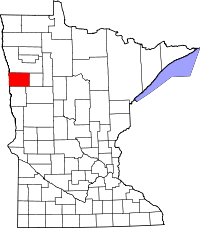 | |
| Townships | ||
| Unincorporated communities | ||
Coordinates: 47°17′59″N 96°30′55″W / 47.29972°N 96.51528°W