Adélie Land
| Adélie Land Terre Adélie |
||||
|---|---|---|---|---|
|
||||
| Motto: "Liberté, égalité, fraternité" | ||||
| Anthem: La Marseillaise | ||||
 |
||||
| Official languages | French | |||
| Government | ||||
| • | President | François Hollande | ||
| • | Administrator | Cécile Pozzo di Borgo[1] | ||
| • | Head of District | François Grosvalet[2] | ||
| French overseas territory | ||||
| • | Coastline discovered | 1840 | ||
| Area | ||||
| • | Total | 432,000 km2 166,796 sq mi |
||
| Population | ||||
| • | estimate | c. 33 (winter) < 80 (summer) |
||
| Currency | Euro (EUR) | |||
| Time zone | (UTC+10) | |||
| Calling code | +262 262 00 2 | |||
| Internet TLD | .tf | |||
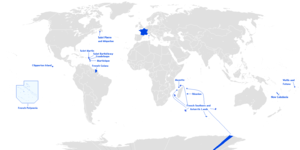
Adélie Land (French: Terre Adélie) is a claimed territory on the continent of Antarctica. It stretches from a coastline area along the Great Southern Ocean inland all the way to the South Pole. This territory is claimed by France as one of five districts of the French Southern and Antarctic Lands, although most countries have not given this their diplomatic recognition.
Geography
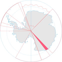
Adélie Land lies between 136° E (near Pourquoi Pas Point at 66°12′S 136°11′E / 66.200°S 136.183°E) and 142° E (near Point Alden at 66°48′S 142°02′E / 66.800°S 142.033°E), with a shore length of about 350 kilometres (220 mi) and with its inland part extending as a sector of a circle about 2,600 kilometres (1,600 mi) toward the South Pole. Adélie Land has border with the Australian Antarctic Territory both on the east and on the west, namely on Clarie Land (part of Wilkes Land) in the west, and George V Land in the east. Its total land area, mostly covered with glaciers, is estimated to be 432,000 square kilometres (167,000 sq mi).
History
The coast of Adélie Land was discovered in 1840 by the French explorer Jules Dumont d'Urville (1790–1842) who named it after his wife, Adèle.[3] This is the basis of the French claim on this Antarctic land.
-
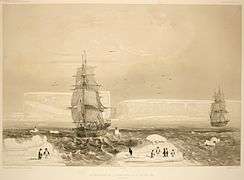
Discovery by Jules Dumont d'Urville, 1840
-
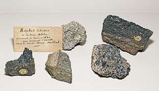
Rocks brought back by the expedition in 1840 MHNT
Research stations
Since January 12, 1956, there has been a manned French research base year-round located at 66°40′S 140°01′E / 66.667°S 140.017°E, the Dumont d'Urville Station, with a winter population of about 33, but which goes up to about 78 during the Antarctic summer. The first French station, Port Martin, was built April 9, 1950 at 66°49′04″S 141°23′39″E / 66.81778°S 141.39417°E, but it was destroyed by a fire during the night of January 22–23, 1952. Port Martin housed a winter population of 11 in 1950–51 and 17 in 1951–52.[4]
France also had an inland station on the Antarctic ice sheet long ago, about 320 km from the coast and from Dumont d'Urville Station, at an elevation of about 2400 meters, the Charcot Station (named for Jean-Baptiste Charcot) at 69°22′S 139°01′E / 69.367°S 139.017°E, built for the International Geophysical Year of 1957–58. This was occupied from January 1957 through 1960, but housed only three men.
In popular culture
The Dumont d'Urville research station was the filming location of the documentary March of the Penguins (2005).[5]
See also
References
- ↑ Official nomination
- ↑ List of chefs de district
- ↑ Dunmore, John (2007). From Venus to Antarctica: The Life of Dumont D'Urville. Auckland: Exisle Publ. p. 209. ISBN 9780908988716.
- ↑ "Fire destroys station in Antarctica, French expedition's loss". The Times. January 26, 1952.
- ↑ "The Emperor's Close-Up". National Geographic's Adventure. National Geographic Society. 2007. Retrieved 29 May 2013.
External links
Coordinates: 75°00′S 139°00′E / 75.000°S 139.000°E
Districts of the French Southern and Antarctic Lands | ||
|---|---|---|
| ||
| |||||||||||||||||||
| |||||||||||||||||||
| |||||||||||||||||||
| Territorial claims | 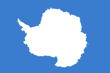 | |
|---|---|---|
| Other territories |
| |
| Former territories | ||
| General | .svg.png) | |
|---|---|---|
| Geographic regions | ||
| Waterways | ||
| Famous explorers | ||