Albarracín
| Albarracín | |||
|---|---|---|---|
| Municipality | |||
|
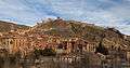
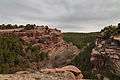
Albarracín, in a meander of the Guadalaviar River, viewed from Torre del Andador. | |||
| |||
 | |||
 Albarracín Location in Spain | |||
| Coordinates: 40°24′30″N 1°26′22″W / 40.40833°N 1.43944°WCoordinates: 40°24′30″N 1°26′22″W / 40.40833°N 1.43944°W | |||
| Country |
| ||
| Autonomous community | Aragón | ||
| Province | Teruel | ||
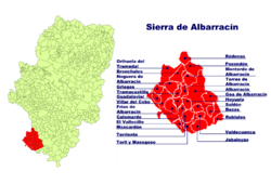
| Comarca | Sierra de Albarracín | ||
| Judicial district | Teruel | ||
| Government | |||
| • Alcalde | Francisco Martí Soriano (2007) (PAR) | ||
| Area | |||
| • Total | 452.72 km2 (174.80 sq mi) | ||
| Elevation | 1,182 m (3,878 ft) | ||
| Population (2015) | |||
| • Total | 1,049 | ||
| • Density | 2.3/km2 (6.0/sq mi) | ||
| Demonym(s) |
Albarracinense, -a Albarriciense, -a Lobetano, -a | ||
| Time zone | CET (UTC+1) | ||
| • Summer (DST) | CEST (UTC+2) | ||
| Postal code | 44100 | ||
| Dialing code | 978 | ||
| Website | Official website | ||


.svg.png)
Albarracín is a Spanish town, in the province of Teruel, part of the autonomous community of Aragon. According to the 2007 census (INE), the municipality had a population of 1075 inhabitants. Albarracín is the capital of the mountainous Sierra de Albarracín Comarca[1]
Albarracín is a picturesque town surrounded by stony hills and the town was declared a Monumento Nacional in 1961.[2]
History
The town is named for the Moorish Al Banū Razín family that once had been dominant in the area during the period of Muslim domination in the Iberian Peninsula.
From 1167 to 1300, Albarracín was an independent lordship known as the Sinyoría d'Albarrazín which was established after the partition of the Taifa of Albarracín under the control of Pedro Ruiz de Azagra. It was eventually conquered by Peter III of Aragon in 1284, and the ruling family, the House of Azagra was deposed. The last person to actually hold the title of Señor de Albarracín was Juan Núñez I de Lara, although his son, Juan Núñez II de Lara continued on as the pretender to the title until 1300 when the city and its lands were officially incorporated into the Kingdom of Aragon.

Geography
The town is located in a meander of the Guadalaviar River. The Sierra de Albarracín mountain range rises to the South and West of the town.
Demographic growth
| Albarracín demographic trend[3] | |||||||||||||||||||
|---|---|---|---|---|---|---|---|---|---|---|---|---|---|---|---|---|---|---|---|
| 1857 | 1887 | 1900 | 1910 | 1920 | 1930 | 1940 | 1950 | 1960 | 1970 | 1981 | 1991 | 2001 | 2006 | ||||||
| Population | 1,883 | 1,953 | 1,897 | 1,689 | 1,688 | 1,576 | 1,582 | 1,467 | 1,376 | 1,187 | 1,068 | 1,164 | 1,050 | 1,076 | |||||
See also
| Wikimedia Commons has media related to Albarracín. |
- Taifa of Albarracin
- Sinyoría d'Albarrazín
- Diocese of Teruel and Albarracín.
- Diocese of Albarracín (1577–1852).
Gallery
-
City walls.
-
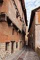
Typical narrow street in the village.
-
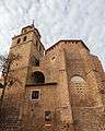
Cathedral.
-

Square in Albarracín.
-

Convento of Discalced Carmelites.
-
Pinares de Rodeno Forest near Albarracín.
References
External links
- Albarracín on Diputación de Teruel (Spanish)
- Turismo Albarracin (Spanish)