Amettes
| Amettes | |
|---|---|
 | |
 Amettes | |
|
Location within Hauts-de-France region  Amettes | |
| Coordinates: 50°31′53″N 2°23′36″E / 50.5314°N 2.3933°E / 50.5314; 2.3933Coordinates: 50°31′53″N 2°23′36″E / 50.5314°N 2.3933°E / 50.5314; 2.3933 | |
| Country | France |
| Region | Hauts-de-France |
| Department | Pas-de-Calais |
| Arrondissement | Béthune |
| Canton | Auchel |
| Intercommunality | Artois-Lys |
| Government | |
| • Mayor (2008–2014) | Martial Berthe |
| Area1 | 6.82 km2 (2.63 sq mi) |
| Population (2009)2 | 500 |
| • Density | 73/km2 (190/sq mi) |
| Time zone | CET (UTC+1) |
| • Summer (DST) | CEST (UTC+2) |
| INSEE/Postal code | 62029 / 62260 |
| Elevation |
62–121 m (203–397 ft) (avg. 86 m or 282 ft) |
|
1 French Land Register data, which excludes lakes, ponds, glaciers > 1 km² (0.386 sq mi or 247 acres) and river estuaries. 2 Population without double counting: residents of multiple communes (e.g., students and military personnel) only counted once. | |
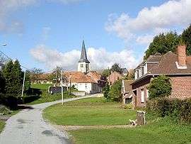
Amettes is a commune in the Pas-de-Calais department in the Hauts-de-France region of France.
Geography
A farming village situated some 11 miles (17.7 km) west of Béthune and 32 miles (51.5 km) southwest of Lille, at the junction of the D69 and the D341 roads and by the banks of the river Nave.
Population
| Historical population | ||
|---|---|---|
| Year | Pop. | ±% |
| 1962 | 533 | — |
| 1968 | 566 | +6.2% |
| 1975 | 507 | −10.4% |
| 1982 | 505 | −0.4% |
| 1990 | 507 | +0.4% |
| 1999 | 474 | −6.5% |
| 2009 | 500 | +5.5% |
Sights
- The church of St. Sulpice, dating from the sixteenth century.
- The war memorial.
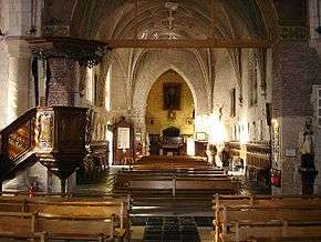
Church interior
Personalities
Benedict Joseph Labre, Catholic saint, was born here in 1748.
See also
References
External links
| Wikimedia Commons has media related to Amettes. |
- The war memorial at Amettes (French)
- Amettes on the Quid website (French)
This article is issued from Wikipedia - version of the 11/6/2016. The text is available under the Creative Commons Attribution/Share Alike but additional terms may apply for the media files.