Gouy-Saint-André
| Gouy-Saint-André | ||
|---|---|---|
 | ||
| ||
 Gouy-Saint-André | ||
|
Location within Hauts-de-France region  Gouy-Saint-André | ||
| Coordinates: 50°22′28″N 1°53′57″E / 50.3744°N 1.8992°ECoordinates: 50°22′28″N 1°53′57″E / 50.3744°N 1.8992°E | ||
| Country | France | |
| Region | Hauts-de-France | |
| Department | Pas-de-Calais | |
| Arrondissement | Montreuil | |
| Canton | Campagne-lès-Hesdin | |
| Intercommunality | Val de Canche et d'Authie | |
| Government | ||
| • Mayor | Yves Beuvain | |
| Area1 | 13.34 km2 (5.15 sq mi) | |
| Population (1999)2 | 611 | |
| • Density | 46/km2 (120/sq mi) | |
| Time zone | CET (UTC+1) | |
| • Summer (DST) | CEST (UTC+2) | |
| INSEE/Postal code | 62382 / 62870 | |
| Elevation |
30–117 m (98–384 ft) (avg. 89 m or 292 ft) | |
|
1 French Land Register data, which excludes lakes, ponds, glaciers > 1 km² (0.386 sq mi or 247 acres) and river estuaries. 2 Population without double counting: residents of multiple communes (e.g., students and military personnel) only counted once. | ||

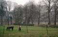
Gouy-Saint-André is a commune in the Pas-de-Calais department in the Hauts-de-France region of France.
Geography
A village situated some 10 miles (16 km) southeast of Montreuil-sur-Mer on the D137 road.
Population
| Year | 1962 | 1968 | 1975 | 1982 | 1990 | 1999 |
|---|---|---|---|---|---|---|
| Population | 584 | 604 | 627 | 633 | 598 | 611 |
| From the year 1962 on: No double counting—residents of multiple communes (e.g. students and military personnel) are counted only once. | ||||||
Places of interest
- Church of St. Martin, dating from the sixteenth century.
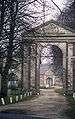
- The abbey of St. Martin.
In 1130, monks of the Premonstratensian Order chose a site on the plateau between the rivers Canche and Authie to build their abbey. The church had begun in 1156 and consecrated in 1220. It was surrounded by many buildings and had a large tower, a barn and two cloisters. Hostilities in the sixteenth and seventeenth century caused much damage. In the early years of the 18th century, the church building was reconstructed, as was the rest of the abbey around 1751 under the leadership of Dom Ignace Crépin with the guidance of the architect Arrageois Merville.
After the revolution only the abbey church and agricultural outbuildings were left standing. The Marquis de Riencourt then transformed it into a chateau, Farm buildings were built between 1752 and 1755 by architect Claude Brunion and were expanded up to 1784. The current buildings facades are exceptional architecturally with bricks and stones.
The chateau was accidentally burned down by British troops in 1918.
The triangular pediment over the main gate bears the arms of the abbey and of the bishop of Amiens. It is typical of the classical architectural style of that period.
See also
References
External links
| Wikimedia Commons has media related to Gouy-Saint-André. |