Anvin
| Anvin | ||
|---|---|---|
 | ||
| ||
 Anvin | ||
|
Location within Hauts-de-France region  Anvin | ||
| Coordinates: 50°26′50″N 2°15′22″E / 50.4472°N 2.2561°E / 50.4472; 2.2561Coordinates: 50°26′50″N 2°15′22″E / 50.4472°N 2.2561°E / 50.4472; 2.2561 | ||
| Country | France | |
| Region | Hauts-de-France | |
| Department | Pas-de-Calais | |
| Arrondissement | Arras | |
| Canton | Heuchin | |
| Intercommunality | Pays d'Heuchin | |
| Government | ||
| • Mayor (2008–2014) | André Olivier | |
| Area1 | 7.83 km2 (3.02 sq mi) | |
| Population (2009)2 | 803 | |
| • Density | 100/km2 (270/sq mi) | |
| Time zone | CET (UTC+1) | |
| • Summer (DST) | CEST (UTC+2) | |
| INSEE/Postal code | 62036 / 62134 | |
| Elevation |
51–150 m (167–492 ft) (avg. 60 m or 200 ft) | |
|
1 French Land Register data, which excludes lakes, ponds, glaciers > 1 km² (0.386 sq mi or 247 acres) and river estuaries. 2 Population without double counting: residents of multiple communes (e.g., students and military personnel) only counted once. | ||

This article is about the commune in France. For the Linux programmer, see Hans Peter Anvin.
Anvin is a commune in the Pas-de-Calais department in northern France.
Geography
Anvin is a farming village located in the Ternoise river valley, 28 miles (44 km) northwest of Arras, at the junction of the D343, D70 and D94 roads.
Population
The inhabitants are called Anvinois.
| Historical population | ||
|---|---|---|
| Year | Pop. | ±% |
| 1962 | 604 | — |
| 1968 | 615 | +1.8% |
| 1975 | 587 | −4.6% |
| 1982 | 639 | +8.9% |
| 1990 | 666 | +4.2% |
| 1999 | 741 | +11.3% |
| 2009 | 803 | +8.4% |
Sights
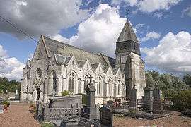
- The church of St. Leger, dating from the sixteenth century.
- The ruins of a seventeenth-century chateau.
- Vestiges of a watermill.
See also
References
External links
| Wikimedia Commons has media related to Anvin. |
- Anvin on the Quid website (French)
This article is issued from Wikipedia - version of the 10/16/2016. The text is available under the Creative Commons Attribution/Share Alike but additional terms may apply for the media files.