Andøy
| Andøy kommune | |||
|---|---|---|---|
| Municipality | |||
|
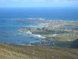
View of the village of Andenes in Andøy | |||
| |||
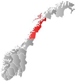
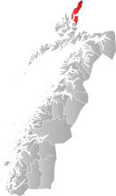 Andøy within Nordland | |||
| Coordinates: 69°5′40″N 15°45′52″E / 69.09444°N 15.76444°ECoordinates: 69°5′40″N 15°45′52″E / 69.09444°N 15.76444°E | |||
| Country | Norway | ||
| County | Nordland | ||
| District | Vesterålen | ||
| Administrative centre | Andenes | ||
| Government | |||
| • Mayor (1999) | Jonni Helge Solsvik (H) | ||
| Area | |||
| • Total | 655.69 km2 (253.16 sq mi) | ||
| • Land | 616.04 km2 (237.85 sq mi) | ||
| • Water | 39.65 km2 (15.31 sq mi) | ||
| Area rank | 169 in Norway | ||
| Population (2012) | |||
| • Total | 5,032 | ||
| • Rank | 182 in Norway | ||
| • Density | 8.2/km2 (21/sq mi) | ||
| • Change (10 years) | -9.3 % | ||
| Demonym(s) | Andværing[1] | ||
| Time zone | CET (UTC+1) | ||
| • Summer (DST) | CEST (UTC+2) | ||
| ISO 3166 code | NO-1871 | ||
| Official language form | Neutral | ||
| Website |
www | ||
|
| |||

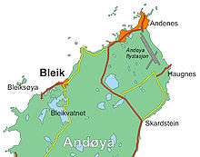
Andøy is the northernmost municipality in Nordland county, Norway. It is part of the Vesterålen archipelago. The main island in the municipality is Andøya. The administrative centre of the municipality is the village of Andenes. Other villages in the municipality include Bjørnskinn, Bleik, Dverberg, Fiskenes, Fornes, Nordmela, Risøyhamn, Skarstein, Å, Åknes, and Åse.
General information
The municipality of Andøy was established as a new municipality on 1 January 1964 after the merger of the old municipalities of Andenes, Bjørnskinn, and Dverberg. Initially, Andøy had 7,366 residents. The municipal boundaries have not changed since that time.[2]
Name
The Old Norse form of the name was Andarøy (from Amdarøy). The first element is the genitive case of the old uncompounded name of the island: Ǫmd. The last element is øy which means "island". The meaning of the uncompounded name is unknown.[3]
Coat-of-arms
The coat-of-arms is from modern times. They were granted on 7 January 1983. The arms show a silver wave on a blue background. It was chosen as a symbol for the fact that the municipality is situated at the sea and that fishing is important economically to the municipality.[4]
Churches
The Church of Norway has three parishes (sokn) within the municipality of Andøy. It is part of the Vesterålen deanery in the Diocese of Sør-Hålogaland.
| Parish (Sokn) | Church Name | Location of the Church | Year Built |
|---|---|---|---|
| Andenes | Andenes Church | Andenes | 1876 |
| Bjørnskinn | Bjørnskinn Church | Bjørnskinn | 1885 |
| Dverberg | Dverberg Church | Dverberg | 1843 |
| Fornes Chapel | Fornes | 1965 |
Geography
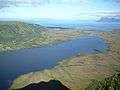
The municipality of Andøy is spread across the island of Andøya (the northernmost island in the Vesterålen archipelago) and the northeastern part of the island of Hinnøya (the largest and most populous island in Norway). The municipality also consists of smaller skerries including Bleiksøya, Vomma, and Stavaøyan. Andøy is located between the Gavlfjorden and the Andfjorden, and the Risøysundet strait separates the two main islands in Andøy. The Andøy Bridge connects the two islands.
The midsection of the island consists of bogs and marshes, known for their Arctic cloudberries. There are numerous lakes on the island including Bleiksvatnet and Skogvollvatnet. The island is also the only place in continental Norway where coal and fossils from dinosaurs are found. Forfjorddalen nature reserve on Hinnøya has some of the oldest pine trees in Scandinavia, some more than 700 years old.[5]
Birdlife
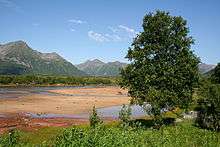
Lying furthest north in the area known as Vesterålen, Andøy is a mixture of vast areas of marshland fens, with a backdrop of high peaked mountains such as Kvasstinden. The coast is famous for its sheltered bays with white sandy shores. The area has a rich bird life and this is reflected in some good birding localities like Forfjorddalen Nature Reserve and Skogvoll, the latter a Ramsar site of international importance.
The bird cliff at Bleiksøya, outside of Bleik, is a spectacular and photogenic landmark outside the northern part of Andøya, with many species of seabirds including puffin.[6]
Climate
| Climate data for Andøya | |||||||||||||
|---|---|---|---|---|---|---|---|---|---|---|---|---|---|
| Month | Jan | Feb | Mar | Apr | May | Jun | Jul | Aug | Sep | Oct | Nov | Dec | Year |
| Average high °C (°F) | 0.3 (32.5) |
0.1 (32.2) |
0.8 (33.4) |
3.3 (37.9) |
7.5 (45.5) |
11.1 (52) |
13.5 (56.3) |
13.3 (55.9) |
10.0 (50) |
6.2 (43.2) |
2.8 (37) |
1.1 (34) |
5.8 (42.4) |
| Daily mean °C (°F) | −2.1 (28.2) |
−2.2 (28) |
−1.4 (29.5) |
1.1 (34) |
5.2 (41.4) |
8.5 (47.3) |
11.0 (51.8) |
11.0 (51.8) |
7.8 (46) |
4.2 (39.6) |
0.9 (33.6) |
−1.2 (29.8) |
3.6 (38.5) |
| Average low °C (°F) | −5.1 (22.8) |
−5.2 (22.6) |
−4.4 (24.1) |
−1.8 (28.8) |
2.5 (36.5) |
6.2 (43.2) |
8.7 (47.7) |
8.3 (46.9) |
5.2 (41.4) |
1.7 (35.1) |
−1.7 (28.9) |
−4.0 (24.8) |
0.9 (33.6) |
| Average precipitation mm (inches) | 98 (3.86) |
86 (3.39) |
79 (3.11) |
68 (2.68) |
53 (2.09) |
61 (2.4) |
67 (2.64) |
77 (3.03) |
108 (4.25) |
144 (5.67) |
109 (4.29) |
110 (4.33) |
1,060 (41.73) |
| Average precipitation days (≥ 1 mm) | 15.3 | 13.1 | 13.5 | 13.1 | 10.6 | 11.8 | 12.1 | 12.8 | 16.6 | 19.2 | 17.0 | 17.4 | 172.5 |
| Source: Norwegian Meteorological Institute[7] | |||||||||||||
Government
All municipalities in Norway, including Andøy, are responsible for primary education (through 10th grade), outpatient health services, senior citizen services, unemployment and other social services, zoning, economic development, and municipal roads. The municipality is governed by a municipal council of elected representatives, which in turn elect a mayor.
Municipal council
The municipal council (Kommunestyre) of Andøy is made up of 23 representatives that are elected to every four years. Currently, the party breakdown is as follows:[8]
| Party Name | Name in Norwegian | Number of representatives | |
|---|---|---|---|
| Labour Party | Arbeiderpartiet | 5 | |
| Progress Party | Fremskrittspartiet | 2 | |
| Conservative Party | Høyre | 9 | |
| Christian Democratic Party | Kristelig Folkeparti | 1 | |
| Green Party | Miljøpartiet De Grønne | 1 | |
| Centre Party | Senterpartiet | 2 | |
| Liberal Party | Venstre | 1 | |
| Local Lists | Lokale lister | 2 | |
| Total number of members: | 23 | ||
Transportation
The Hurtigruten boat stops at Risøyhamn. Andøya Airport at Andenes is served by Widerøe airlines. During the summer, Andenes is connected to Gryllefjord on the island of Senja by ferry. By car, you reach Andøy on Norwegian County Road 82, northbound from Sortland.
Military
Andøya Air Station is located next to Andenes. It is the home of the 333rd Squadron of the Royal Norwegian Air Force and houses all P-3 Orion maritime patrol aircraft in the Norwegian Armed Forces. Andøya Rocket Range is a civilian facility for launching sounding rockets, located a few kilometres south of Andenes.
References
- ↑ "Navn på steder og personer: Innbyggjarnamn" (in Norwegian). Språkrådet. Retrieved 2015-12-01.
- ↑ Jukvam, Dag (1999). "Historisk oversikt over endringer i kommune- og fylkesinndelingen" (PDF) (in Norwegian). Statistisk sentralbyrå.
- ↑ Store norske leksikon. "Andøy" (in Norwegian). Retrieved 2012-08-05.
- ↑ Norske Kommunevåpen (1990). "Nye kommunevåbener i Norden". Retrieved 2008-11-18.
- ↑ "Forfjorddalen naturreservat" (in Norwegian). Retrieved 2008-11-18.
- ↑ "Bleiksøya naturreservat" (in Norwegian). Retrieved 2008-11-18.
- ↑ "eKlima Web Portal". Norwegian Meteorological Institute.
- ↑ "Table: 04813: Members of the local councils, by party/electoral list at the Municipal Council election (M)" (in Norwegian). Statistics Norway. 2015. Archived from the original on 2016-03-06.
External links
| Wikimedia Commons has media related to Andøy. |
 Nordland travel guide from Wikivoyage
- Municipal fact sheet from Statistics Norway
