Antrim, New Hampshire
| Antrim, New Hampshire | ||
|---|---|---|
| Town | ||
|
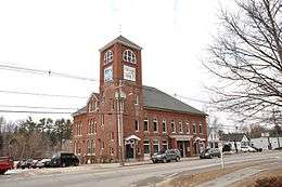
Antrim Town Hall | ||
| ||
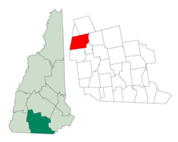 Location in Hillsborough County, New Hampshire | ||
| Coordinates: 43°01′51″N 71°56′20″W / 43.03083°N 71.93889°WCoordinates: 43°01′51″N 71°56′20″W / 43.03083°N 71.93889°W | ||
| Country | United States | |
| State | New Hampshire | |
| County | Hillsborough | |
| Incorporated | 1845 | |
| Government | ||
| • Board of Selectmen |
John Robertson, Chair Michael Genest Robert Edwards | |
| • Town Administrator | Donna Hanson | |
| Area | ||
| • Total | 36.5 sq mi (94.5 km2) | |
| • Land | 35.7 sq mi (92.4 km2) | |
| • Water | 0.8 sq mi (2.1 km2) 2.27% | |
| Elevation | 712 ft (217 m) | |
| Population (2010) | ||
| • Total | 2,637 | |
| • Density | 72/sq mi (28/km2) | |
| Time zone | Eastern (UTC-5) | |
| • Summer (DST) | Eastern (UTC-4) | |
| ZIP code | 03440 | |
| Area code(s) | 603 | |
| FIPS code | 33-01700 | |
| GNIS feature ID | 0873533 | |
| Website |
www | |
Antrim is a town in Hillsborough County, New Hampshire, United States. The population was 2,637 at the 2010 census.[1] The primary settlement in the town, where 1,397 people resided at the 2010 census,[1] is defined as the Antrim census-designated place (CDP) and is located at the intersection of U.S. Route 202 and New Hampshire Route 31. The town of Antrim also includes the villages of Antrim Center, North Branch, Clinton Village and South Village.
History
Settled in 1741 and incorporated on 22 March 1777,[2] this town did not get its incorporated name until 1778. It was named for County Antrim in northern Ireland, which was the native home of the land's owner, Philip Riley. Scots-Irish settlers established a Presbyterian church in Antrim in 1788.[3]
With falls providing water power, Great Brook was once lined with over twenty mills along its course from Gregg Lake to the Contoocook River. Commercial development centered on South Antrim. Cutlery was the major industry in this town, beginning with the manufacturing of apple-paring machines in 1864. The manufacture of cutlery continued in Antrim through 1989. The town is now largely a bedroom community for Peterborough and Hillsborough. It was home to the now-defunct Nathaniel Hawthorne College.[4]
Geography
According to the United States Census Bureau, the town has a total area of 36.5 square miles (95 km2), of which 35.7 sq mi (92 km2) is land and 0.8 sq mi (2.1 km2) is water, comprising 2.27% of the town. Antrim is drained by the Contoocook River and its North Branch, in addition to Great Brook. Gregg Lake and Willard Pond are in the west. Bald Mountain, elevation 2,037 feet (621 m) above sea level and the highest point in Antrim, is also in the west. Antrim lies fully within the Merrimack River watershed.[5]
The town center, defined as a census-designated place (CDP), covers an area of 4.5 square miles (12 km2), about 12% of the area of the town.
Demographics
| Historical population | |||
|---|---|---|---|
| Census | Pop. | %± | |
| 1790 | 528 | — | |
| 1800 | 1,059 | 100.6% | |
| 1810 | 1,277 | 20.6% | |
| 1820 | 1,330 | 4.2% | |
| 1830 | 1,309 | −1.6% | |
| 1840 | 1,225 | −6.4% | |
| 1850 | 1,143 | −6.7% | |
| 1860 | 1,123 | −1.7% | |
| 1870 | 904 | −19.5% | |
| 1880 | 817 | −9.6% | |
| 1890 | 1,248 | 52.8% | |
| 1900 | 1,366 | 9.5% | |
| 1910 | 1,235 | −9.6% | |
| 1920 | 1,052 | −14.8% | |
| 1930 | 1,254 | 19.2% | |
| 1940 | 1,127 | −10.1% | |
| 1950 | 1,030 | −8.6% | |
| 1960 | 1,121 | 8.8% | |
| 1970 | 2,122 | 89.3% | |
| 1980 | 2,208 | 4.1% | |
| 1990 | 2,360 | 6.9% | |
| 2000 | 2,449 | 3.8% | |
| 2010 | 2,637 | 7.7% | |
| Est. 2015 | 2,658 | [6] | 0.8% |
As of the census of 2000, there were 2,449 people, 932 households, and 624 families residing in the town. The population density was 68.7 people per square mile (26.5/km²). There were 1,160 housing units at an average density of 12.6 units/km² (32.5 units/sq mi). The racial makeup of the town was 98.04% White, 0.24% African American, 0.37% Native American, 0.37% Asian, 0.00% Pacific Islander, 0.04% from other races, and 0.94% from two or more races. 0.78% of the population were Hispanic or Latino of any race.
There were 932 households out of which 35.3% had children under the age of 18 living with them, 55.4% were married couples living together, 7.8% have a woman whose husband does not live with her, and 33.0% were non-families. 26.0% of all households were made up of individuals and 9.9% had someone living alone who was 65 years of age or older. The average household size was 2.62 and the average family size was 3.17.
In the town the population was spread out with 29.2% under the age of 18, 6.1% from 18 to 24, 28.2% from 25 to 44, 25.5% from 45 to 64, and 11.0% who were 65 years of age or older. The median age was 37 years. For every 100 females there were 98.5 males. For every 100 females age 18 and over, there were 94.8 males.
The median income for a household in the town was $45,677, and the median income for a family was $50,650. Males had a median income of $36,033 versus $24,313 for females. The per capita income for the town was $18,978. 11.5% of the population and 8.3% of families were below the poverty line. Out of the total people living in poverty, 14.5% are under the age of 18 and 16.0% are 65 or older.
Town center
As of the census of 2000, there were 1,389 people, 526 households, and 341 families residing in the CDP (or census-designated place) occupying the town center. The population density was 308.9 people per square mile (119.2/km²). There were 541 housing units at an average density of 46.4 persons/km² (120.3 persons/sq mi). The racial makeup of the town was 97.77% White, 0.29% African American, 0.58% Native American, 0.22% Asian, 0.07% from other races, and 1.08% from two or more races. 0.43% of the population were Hispanic or Latino of any race.
There were 526 households out of which 38.0% had children under the age of 18 living with them, 51.3% were married couples living together, 10.1% have a woman whose husband does not live with her, and 35.0% were non-families. 29.3% of all households were made up of individuals and 13.1% had someone living alone who was 65 years of age or older. The average household size was 2.62 and the average family size was 3.25.
In the settlement the population was spread out with 31.1% under the age of 18, 6.3% from 18 to 24, 27.8% from 25 to 44, 22.2% from 45 to 64, and 12.5% who were 65 years of age or older. The median age was 36 years. For every 100 females there were 91.9 males. For every 100 females age 18 and over, there were 86.9 males.
The median income for a household is $41,042, and the median income for a family was $48,854. Males had a median income of $32,308 versus $22,368 for females. The per capita income for the town was $16,935. 13.8% of the population and 9.1% of families were below the poverty line. Out of the total people living in poverty, 15.3% are under the age of 18 and 21.1% are 65 or older.
Sites of interest
| Wikimedia Commons has media related to Antrim, New Hampshire. |
References
- 1 2 United States Census Bureau, American FactFinder, 2010 Census figures. Retrieved March 23, 2011.
- ↑ Statistics and Gazetteer of New-Hampshire (1875)
- ↑ Austin J. Coolidge & John B. Mansfield, A History and Description of New England; Boston, Massachusetts 1859
- ↑ New Hampshire Economic and Labor Market Information Bureau Profile Archived April 21, 2008, at the Wayback Machine.
- ↑ Foster, Debra H.; Batorfalvy, Tatianna N.; Medalie, Laura (1995). Water Use in New Hampshire: An Activities Guide for Teachers. U.S. Department of the Interior and U.S. Geological Survey.
- ↑ "Annual Estimates of the Resident Population for Incorporated Places: April 1, 2010 to July 1, 2015". Retrieved July 2, 2016.
- ↑ "Census of Population and Housing". Census.gov. Archived from the original on May 11, 2015. Retrieved June 4, 2016.
External links
- Town of Antrim official website
- James A. Tuttle Library
- New Hampshire Economic and Labor Market Information Bureau Profile
Municipalities and communities of Hillsborough County, New Hampshire, United States | ||
|---|---|---|
| Cities | 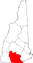 | |
| Towns | ||
| CDPs | ||
| Other villages | ||