Hillsborough, New Hampshire
| Hillsborough, New Hampshire | ||
|---|---|---|
| Town | ||
|
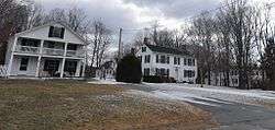
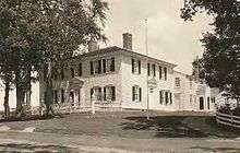
Houses in historic Hillsborough Center | ||
| ||
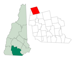 Location in Hillsborough County, New Hampshire | ||
| Coordinates: 43°06′53″N 71°53′42″W / 43.11472°N 71.89500°WCoordinates: 43°06′53″N 71°53′42″W / 43.11472°N 71.89500°W | ||
| Country | United States | |
| State | New Hampshire | |
| County | Hillsborough | |
| Incorporated | 1772 | |
| Government | ||
| • Board of Selectmen |
Alan B. Urquhart, Chair James C. Bailey III David N. Fullerton | |
| • Town Administrator | Laura Buono | |
| Area | ||
| • Total | 44.6 sq mi (115.6 km2) | |
| • Land | 43.6 sq mi (113.0 km2) | |
| • Water | 1.0 sq mi (2.6 km2) 2.23% | |
| Elevation | 636 ft (194 m) | |
| Population (2010) | ||
| • Total | 6,011 | |
| • Density | 138/sq mi (53.2/km2) | |
| Time zone | Eastern (UTC-5) | |
| • Summer (DST) | Eastern (UTC-4) | |
| ZIP code | 03244 | |
| Area code(s) | 603 | |
| FIPS code | 33-36180 | |
| GNIS feature ID | 0873625 | |
| Website |
www | |
Hillsborough, frequently spelled Hillsboro, is a town in Hillsborough County, New Hampshire, United States. The population was 6,011 at the 2010 census.[1] The town is home to Fox State Forest and part of Low State Forest.
The main village of the town, where 1,976 people resided at the 2010 census,[2] is defined as the Hillsborough census-designated place (CDP), and encompasses the central urban area of the town, located along the Contoocook River at the junction of New Hampshire Route 149 with Henniker Street and Main Street. The town also includes the villages of Hillsborough Center, Hillsborough Upper Village, Hillsborough Lower Village, and Emerald Lake Village.
History
The town was first granted in 1735 by colonial governor of Massachusetts and New Hampshire Jonathan Belcher as "Number Seven," one in a line of nine Massachusetts towns set up as defense barriers against Indian attacks. The towns were renamed after the border between the two provinces was fixed in 1739, placing the towns in New Hampshire. Settled in 1741, the town was granted in 1748 by Governor Benning Wentworth as "Hillsborough," named for Sir Wills Hill, Earl of Hillsborough. It would be incorporated in 1772 by Governor John Wentworth.
Hillsborough was the birthplace in 1804 of Franklin Pierce, 14th president of the United States, and the only president from New Hampshire. The Pierce Homestead was built in 1804 by his father, Benjamin Pierce, a general in the Revolutionary War, and twice governor of New Hampshire. Restored in 1925, the home was designated a National Historic Landmark in 1961. Listed on the National Register of Historic Places, the house is today a museum owned by the state, and operated by the Hillsborough Historical Society.
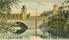
Five granite arch bridges built during the 19th century in Hillsborough are designated as National Historic Civil Engineering Landmarks.
Railroad service was supplied to Hillsborough by the Boston and Maine Railroad from 1878 to 1972. Rail service north to Henniker had ceased in 1942, and Hillsborough became the end point on a line that once stretched in an arc from Nashua to Concord, New Hampshire. The rails in Hillsborough were torn up in 1979. Hillsborough was once home to an iconic railroad covered bridge and a curved wooden trestle, both of which burned due to arson in 1985 after rail service had ended. The Hillsborough Branch now ends at Bennington; the line from Bennington to Hillsborough is a rail trail.
Geography
According to the United States Census Bureau, the town has a total area of 44.6 square miles (115.6 km2), of which 43.6 sq mi (113.0 km2) is land and 1.0 sq mi (2.6 km2) is water, comprising 2.23% of the town.[1] The town center, or census-designated place, has a total area of 1.6 sq mi (4.2 km2).[2]
The highest point in Hillsborough is Thompson Hill, at 1,768 feet (539 m) above sea level, in the northern part of town. Hillsborough is drained by the Contoocook River, in addition to Beard's and Sand brooks. Part of Franklin Pierce Lake is in the southwest. The town lies fully within the Merrimack River watershed.[3]
Hillsborough is bordered by Windsor to the southwest, Washington to the northwest, Bradford to the north, Henniker to the east, and Antrim and Deering to the south.
Demographics
| Historical population | |||
|---|---|---|---|
| Census | Pop. | %± | |
| 1790 | 798 | — | |
| 1800 | 1,311 | 64.3% | |
| 1810 | 1,592 | 21.4% | |
| 1820 | 1,982 | 24.5% | |
| 1830 | 1,792 | −9.6% | |
| 1840 | 1,808 | 0.9% | |
| 1850 | 1,685 | −6.8% | |
| 1860 | 1,623 | −3.7% | |
| 1870 | 1,595 | −1.7% | |
| 1880 | 1,646 | 3.2% | |
| 1890 | 2,120 | 28.8% | |
| 1900 | 2,254 | 6.3% | |
| 1910 | 2,168 | −3.8% | |
| 1920 | 2,229 | 2.8% | |
| 1930 | 2,160 | −3.1% | |
| 1940 | 2,269 | 5.0% | |
| 1950 | 2,179 | −4.0% | |
| 1960 | 2,310 | 6.0% | |
| 1970 | 2,775 | 20.1% | |
| 1980 | 3,437 | 23.9% | |
| 1990 | 4,498 | 30.9% | |
| 2000 | 4,928 | 9.6% | |
| 2010 | 6,011 | 22.0% | |
| Est. 2015 | 5,981 | [4] | −0.5% |
As of the census of 2010, there were 6,011 people, 2,392 households, and 1,614 families residing in the town. The population density was 137.9 people per square mile (53.2/km²). There were 2,896 housing units at an average density of 66.4 per square mile (25.6/km²). The racial makeup of the town was 96.4% White, 0.6% Black or African American, 0.3% Native American, 0.6% Asian, 0.03% Native Hawaiian or other Pacific Islander, 0.3% some other race, and 1.8% from two or more races. Hispanic or Latino of any race were 1.4% of the population.[6]
There were 2,392 households, out of which 34.2% had children under the age of 18 living with them, 50.2% were headed by married couples living together, 11.6% had a female householder with no husband present, and 32.5% were non-families. 24.5% of all households were made up of individuals, and 8.5% were someone living alone who was 65 years of age or older. The average household size was 2.51, and the average family size was 2.98.[6]
In the town the population was spread out with 24.8% under the age of 18, 7.4% from 18 to 24, 27.1% from 25 to 44, 29.8% from 45 to 64, and 11.0% who were 65 years of age or older. The median age was 38.6 years. For every 100 females there were 98.9 males. For every 100 females age 18 and over, there were 95.3 males.[6]
For the period 2007–2011, the estimated median annual income for a household in the town was $54,386, and the median income for a family was $67,621. Male full-time workers had a median income of $43,583 versus $32,030 for females. The per capita income for the town was $23,232. About 7.1% of families and 11.2% of the population were below the poverty line, including 8.5% of those under age 18 and 6.5% of those age 65 or over.[7]
Town center
As of the census of 2010, there were 1,976 people, 823 households, and 492 families residing in the primary settlement, or census-designated place (CDP). The population density was 1,235.0 people per square mile (470.5/km²). There were 933 housing units at an average density of 583.1 per square mile (222.1/km²). The racial makeup of the CDP was 95.2% White, 0.7% Black or African American, 0.3% Native American, 0.8% Asian, 0.05% Native Hawaiian or other Pacific Islander, 0.4% some other race, and 2.5% from two or more races. Hispanic or Latino of any race were 1.7% of the population.[8]
There were 823 households, out of which 33.8% had children under the age of 18 living with them, 36.3% were headed by married couples living together, 16.9% had a female householder with no husband present, and 40.2% were non-families. 31.3% of all households were made up of individuals, and 11.3% were someone living alone who was 65 years of age or older. The average household size was 2.40, and the average family size was 3.00.[8]
In the CDP the population was spread out with 25.5% under the age of 18, 11.1% from 18 to 24, 25.3% from 25 to 44, 25.9% from 45 to 64, and 12.2% who were 65 years of age or older. The median age was 35.0 years. For every 100 females there were 94.1 males. For every 100 females age 18 and over, there were 92.3 males.[8]
For the period 2007–2011, the estimated median annual income for a household in the CDP was $50,547, and the median income for a family was $51,688. Male full-time workers had a median income of $41,557 versus $32,206 for females. The per capita income for the CDP was $20,473. About 6.8% of families and 12.9% of the population were below the poverty line, including 9.4% of those under age 18 and 7.6% of those age 65 or over.[9]
Education
Hillsborough is part of School Administrative Unit (SAU) 34. Public schools serving the community of Hillsboro include:
- Hillsboro-Deering Elementary School
- Hillsboro-Deering Middle School
- Hillsboro-Deering High School
Sites of interest
- DAR Museum Room, in the Fuller Public Library.
- Franklin Pierce Homestead (1804)
Notable people
- Wilson Bethel, actor
- Benjamin Pierce Cheney, a founder of American Express
- James Hill, member of the Wisconsin State Assembly and the Wisconsin State Senate
- Benjamin Franklin Keith, vaudeville theater owner
- Benjamin Pierce, Governor of New Hampshire, father of Franklin Pierce
- Benjamin Kendrick Pierce, United States Army officer, son of Benjamin Pierce, brother of Franklin Pierce
- Franklin Pierce, 14th President of the United States
- John Butler Smith, manufacturer and the 44th governor of New Hampshire
References
- 1 2 "Geographic Identifiers: 2010 Demographic Profile Data (G001): Hillsborough town, Hillsborough County, New Hampshire". U.S. Census Bureau, American Factfinder. Retrieved February 7, 2013.
- 1 2 "Geographic Identifiers: 2010 Demographic Profile Data (G001): Hillsborough CDP, New Hampshire". U.S. Census Bureau, American Factfinder. Retrieved February 7, 2013.
- ↑ Foster, Debra H.; Batorfalvy, Tatianna N.; Medalie, Laura (1995). Water Use in New Hampshire: An Activities Guide for Teachers. U.S. Department of the Interior and U.S. Geological Survey.
- ↑ "Annual Estimates of the Resident Population for Incorporated Places: April 1, 2010 to July 1, 2015". Retrieved July 2, 2016.
- ↑ "Census of Population and Housing". Census.gov. Retrieved June 4, 2016.
- 1 2 3 "Profile of General Population and Housing Characteristics: 2010 Demographic Profile Data (DP-1): Hillsborough town, Hillsborough County, New Hampshire". U.S. Census Bureau, American Factfinder. Retrieved February 7, 2013.
- ↑ "Selected Economic Characteristics: 2007–2011 American Community Survey 5-Year Estimates (DP03): Hillsborough town, Hillsborough County, New Hampshire". U.S. Census Bureau, American Factfinder. Retrieved February 7, 2013.
- 1 2 3 "Profile of General Population and Housing Characteristics: 2010 Demographic Profile Data (DP-1): Hillsborough CDP, New Hampshire". U.S. Census Bureau, American Factfinder. Retrieved February 7, 2013.
- ↑ "Selected Economic Characteristics: 2007–2011 American Community Survey 5-Year Estimates (DP03): Hillsborough CDP, New Hampshire". U.S. Census Bureau, American Factfinder. Retrieved February 7, 2013.
External links
| Wikivoyage has a travel guide for Hillsborough, New Hampshire. |
- Town of Hillsborough official website
- Hillsborough Chamber of Commerce
- New Hampshire Economic and Labor Market Information Bureau Profile
- Fuller Public Library
Municipalities and communities of Hillsborough County, New Hampshire, United States | ||
|---|---|---|
| Cities | 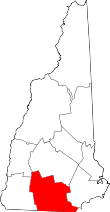 | |
| Towns | ||
| CDPs | ||
| Other villages | ||