Weare, New Hampshire
| Weare, New Hampshire | |
|---|---|
| Town | |
|
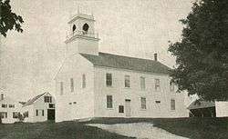
Town Hall c. 1915 | |
| Motto: "A Part of Yesterday in Touch with Tomorrow" | |
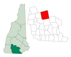 Location in Hillsborough County, New Hampshire | |
| Coordinates: 43°05′41″N 71°43′50″W / 43.09472°N 71.73056°WCoordinates: 43°05′41″N 71°43′50″W / 43.09472°N 71.73056°W | |
| Country | United States |
| State | New Hampshire |
| County | Hillsborough |
| Incorporated | 1764 |
| Government | |
| • Board of Selectmen |
Keith Lacasse, Chair Thomas Clow John (Jack) Meany Jennifer Bohl Frederick Hippler |
| • Town Administrator | Naomi L. Bolton |
| Area | |
| • Total | 59.9 sq mi (155.1 km2) |
| • Land | 58.8 sq mi (152.4 km2) |
| • Water | 1.0 sq mi (2.7 km2) 1.74% |
| Elevation | 633 ft (193 m) |
| Population (2010) | |
| • Total | 8,785 |
| • Density | 150/sq mi (57/km2) |
| Time zone | Eastern (UTC-5) |
| • Summer (DST) | Eastern (UTC-4) |
| ZIP code | 03281 |
| Area code(s) | 603 |
| FIPS code | 33-79780 |
| GNIS feature ID | 0873749 |
| Website |
www |
Weare is a town in Hillsborough County, New Hampshire, United States. The population was 8,785 at the 2010 census.[1] It is close to two important New Hampshire cities, Manchester and Concord.
History
It was granted to veterans of the Canadian wars in 1735 by Governor Jonathan Belcher, who named it Beverly-Canada after their hometown, Beverly, Massachusetts. But the charter was ruled invalid because of a prior claim by the Masonian proprietors, who granted six square miles as Hale's Town to Ichabod Robie in 1749.[2] It was also known as Robie's Town or Weare's Town before being incorporated by Governor Benning Wentworth in 1764 as Weare, after Meshech Weare, who served as the town's first clerk and later went on to become New Hampshire's first governor.[3]
In 1834, Moses Cartland founded Clinton Grove Academy, the first Quaker seminary in the state. A cousin of John Greenleaf Whittier, Cartland named the village where the school was located Clinton Grove, in honor of Dewitt Clinton, chief sponsor of the Erie Canal. The original academy served as a private high school. The complex, which included a classroom building, boarding house, barn and sheds, burned in 1872. Classes were then held in the Quaker meetinghouse across the common until 1874, when a new building was completed.[4] It would serve as the Weare school district from 1877 to 1938.
On September 21, 1938, following several days of heavy rain, the New England Hurricane of 1938 passed through the center of New England. The additional rains from the storm caused the Deering Reservoir dam to breach, releasing a wall of water that rushed down to the Weare Reservoir dam. Although the dam held, the flash flood broke through the land at the side of the dam, releasing millions of gallons of reservoir water. The raging river, completely out of control, washed away everything in its path, leaving parts of Weare devastated. Many active mills were destroyed in the disaster.
In response to the disaster and seasonal flooding, the U.S. Army Corps of Engineers built the 2,000-foot (610 m) long Everett Dam, as part of the Hopkinton-Everett Flood Control Project, which had been authorized by Congress to prevent a recurrence of the devastating floods. The overall project was completed in 1963 at a total cost of $21,400,000. The dam required the village of East Weare to be permanently abandoned, and formed Everett Lake.
In 2005, the town was proposed as the site of the Lost Liberty Hotel, a farmhouse owned at the time by U.S. Supreme Court Associate Justice David Souter. The effort to seize Souter's property for the project, in retaliation for a June 2005 court ruling he supported concerning eminent domain, received international media coverage. However, at the February 4, 2006, deliberative session of the town meeting, a warrant article that would have empowered town officials to take the property was amended by residents in a way that made the March 14, 2006, ballot measure moot.
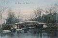 Old bridge c. 1905
 Baptist Church c. 1910
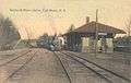 Boston & Maine Railroad station in 1910
 East Weare c. 1910
Geography
According to the United States Census Bureau, the town has a total area of 59.9 square miles (155.1 km2), of which 58.8 sq mi (152.3 km2) is land and 1.0 sq mi (2.6 km2) is water, comprising 1.74% of the town. Weare is drained by the Piscataquog River, which is impounded by Lake Horace in the northwest and by Everett Lake in the northeast. The three highest summits in Weare form a cluster near the center of town. From south to north, they are Mount Dearborn, at 1,211 feet (369 m) above sea level, Mine Hill 1,211 feet (369 m), and Mount Wallingford, approximately 1,210 feet (370 m).
The town is crossed by New Hampshire Route 77, New Hampshire Route 114 and New Hampshire Route 149.
Demographics
| Historical population | |||
|---|---|---|---|
| Census | Pop. | %± | |
| 1790 | 1,924 | — | |
| 1800 | 2,517 | 30.8% | |
| 1810 | 2,634 | 4.6% | |
| 1820 | 2,781 | 5.6% | |
| 1830 | 2,430 | −12.6% | |
| 1840 | 2,375 | −2.3% | |
| 1850 | 2,435 | 2.5% | |
| 1860 | 2,310 | −5.1% | |
| 1870 | 2,092 | −9.4% | |
| 1880 | 1,829 | −12.6% | |
| 1890 | 1,550 | −15.3% | |
| 1900 | 1,553 | 0.2% | |
| 1910 | 1,325 | −14.7% | |
| 1920 | 1,173 | −11.5% | |
| 1930 | 1,287 | 9.7% | |
| 1940 | 1,367 | 6.2% | |
| 1950 | 1,345 | −1.6% | |
| 1960 | 1,420 | 5.6% | |
| 1970 | 1,851 | 30.4% | |
| 1980 | 3,232 | 74.6% | |
| 1990 | 6,193 | 91.6% | |
| 2000 | 7,776 | 25.6% | |
| 2010 | 8,785 | 13.0% | |
| Est. 2015 | 8,913 | [5] | 1.5% |
As of the census[7] of 2000, there were 7,776 people, 2,618 households, and 2,117 families residing in the town. The population density was 132.1 people per square mile (51.0/km²). There were 2,828 housing units at an average density of 48.1 per square mile (18.6/km²). The racial makeup of the town was 98.25% White, 0.17% African American, 0.22% Native American, 0.42% Asian, 0.22% from other races, and 0.72% from two or more races. Hispanic or Latino of any race were 0.69% of the population.
There were 2,618 households out of which 48.2% had children under the age of 18 living with them, 71.0% were married couples living together, 5.6% had a female householder with no husband present, and 19.1% were non-families. 13.4% of all households were made up of individuals and 2.6% had someone living alone who was 65 years of age or older. The average household size was 2.97 and the average family size was 3.28.
In the town the population was spread out with 32.0% under the age of 18, 5.7% from 18 to 24, 36.8% from 25 to 44, 20.7% from 45 to 64, and 4.7% who were 65 years of age or older. The median age was 34 years. For every 100 females there were 101.1 males. For every 100 females age 18 and over, there were 99.5 males.
The median income for a household in the town was $59,924, and the median income for a family was $62,661. Males had a median income of $38,986 versus $27,643 for females. The per capita income for the town was $22,217. About 1.5% of families and 2.5% of the population were below the poverty line, including 1.1% of those under age 18 and 8.2% of those age 65 or over.
Education
Weare has one elementary school, Center Woods Elementary School, serving children in kindergarten through third grade.
Weare Middle School serves children from sixth through eighth grade. Construction on a new middle school facility began in late 2005.
High school students in Weare attend John Stark Regional High School.
Notable people
- Elma Gove, painter
- Gene Robinson, ninth Episcopal bishop of the Diocese of New Hampshire
- David Souter, former associate justice of the U.S. Supreme Court
References
- ↑ United States Census Bureau, American FactFinder, 2010 Census figures. Retrieved March 23, 2011.
- ↑ Warren Brown, Volume 1 of History of Hampton Falls, N.H. Rumford Press, 1900.
- ↑ Austin J. Coolidge & John B. Mansfield, A History and Description of New England; Boston, Massachusetts 1859
- ↑ History of Weare, Hillsborough County, New Hampshire; J.W. Lewis & Company, Philadelphia 1885
- ↑ "Annual Estimates of the Resident Population for Incorporated Places: April 1, 2010 to July 1, 2015". Retrieved July 2, 2016.
- ↑ "Census of Population and Housing". Census.gov. Retrieved June 4, 2016.
- ↑ "American FactFinder". United States Census Bureau. Retrieved 2008-01-31.
External links
- Town of Weare, official website
- Weare profile, New Hampshire Economic and Labor Market Information Bureau
- Clough State Park
- Hopkinton-Everett Lake
Municipalities and communities of Hillsborough County, New Hampshire, United States | ||
|---|---|---|
| Cities | 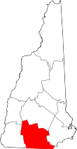 | |
| Towns | ||
| CDPs | ||
| Other villages | ||