Mason, New Hampshire
| Mason, New Hampshire | |
|---|---|
| Town | |
|
Uncle Sam's house | |
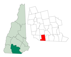 Location in Hillsborough County, New Hampshire | |
| Coordinates: 42°44′37″N 71°46′08″W / 42.74361°N 71.76889°WCoordinates: 42°44′37″N 71°46′08″W / 42.74361°N 71.76889°W | |
| Country | United States |
| State | New Hampshire |
| County | Hillsborough |
| Incorporated | 1768 |
| Government | |
| • Board of Selectmen |
Louise Lavoie, Chair Charles V. Moser Bernard O'Grady |
| Area | |
| • Total | 24.0 sq mi (62.1 km2) |
| • Land | 23.9 sq mi (61.9 km2) |
| • Water | 0.1 sq mi (0.2 km2) 0.25% |
| Elevation | 745 ft (227 m) |
| Population (2010) | |
| • Total | 1,382 |
| • Density | 58/sq mi (22/km2) |
| Time zone | Eastern (UTC-5) |
| • Summer (DST) | Eastern (UTC-4) |
| ZIP code | 03048 |
| Area code(s) | 603 |
| FIPS code | 33-46260 |
| GNIS feature ID | 0873661 |
| Website |
masonnh |
Mason is a town in Hillsborough County, New Hampshire, United States. The population was 1,382 at the 2010 census.[1] Mason, together with Wilton, is home to Russell-Abbott State Forest.
History
Mason was first known as Number One, the first in a line of border towns including area allotted to the Province of New Hampshire after its border with neighboring Massachusetts was fixed in 1739. The town's charter was granted in 1749 by Colonial Governor Benning Wentworth, and in 1768 his nephew, Governor John Wentworth, named it in honor of New Hampshire's founder, Captain John Mason. Captain Mason was the holder of patent with title to the land that became New Hampshire. Greenville was set off from Mason in 1872.[2]
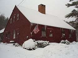
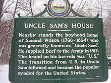
Near the town's center is the boyhood home of Samuel Wilson, the meat-supplier who is believed to have inspired the Uncle Sam character. The private house is today identified by a state historical marker. Another prominent local figure was Elizabeth Orton Jones, an author, illustrator and teacher better known as "Twig." Jones is noted for her recording of town history and her dedication to Andy's Summer Playhouse, a renowned youth theater founded in Mason.[3] Pickity Place, a local cottage built in 1759 by Ebenezer Blood, was the model for the grandmother's house in Jones' 1948 illustrated version of Little Red Riding Hood. Pickity Place was created by David and Judith Walter. It was also the home of Ron Harry, Boston Garden organist from 1983–1995 and for the Boston Celtics in the TD Banknorth Garden until his death in 2004.[4]
Geography
According to the United States Census Bureau, the town has a total area of 24.0 square miles (62.2 km2), of which 23.9 square miles (62 km2) is land and 0.1 square miles (0.26 km2) (0.25%) is water. Mason is drained by Spaulding Brook. The town's highest point is 1,100 feet (340 m) above sea level, on an unnamed summit near the border with Greenville.
Mason is bordered by New Ipswich and Greenville to the west, Wilton to the north, Milford to the northeast, Brookline to the east, and Ashby, Massachusetts and Townsend, Massachusetts to the south.
The town is served by state routes 31, 123 and 124.
Demographics
| Historical population | |||
|---|---|---|---|
| Census | Pop. | %± | |
| 1790 | 922 | — | |
| 1800 | 1,179 | 27.9% | |
| 1810 | 1,077 | −8.7% | |
| 1820 | 1,313 | 21.9% | |
| 1830 | 1,403 | 6.9% | |
| 1840 | 1,275 | −9.1% | |
| 1850 | 1,626 | 27.5% | |
| 1860 | 1,559 | −4.1% | |
| 1870 | 1,364 | −12.5% | |
| 1880 | 645 | −52.7% | |
| 1890 | 629 | −2.5% | |
| 1900 | 459 | −27.0% | |
| 1910 | 325 | −29.2% | |
| 1920 | 278 | −14.5% | |
| 1930 | 254 | −8.6% | |
| 1940 | 249 | −2.0% | |
| 1950 | 288 | 15.7% | |
| 1960 | 349 | 21.2% | |
| 1970 | 518 | 48.4% | |
| 1980 | 792 | 52.9% | |
| 1990 | 1,212 | 53.0% | |
| 2000 | 1,147 | −5.4% | |
| 2010 | 1,382 | 20.5% | |
| Est. 2015 | 1,409 | [5] | 2.0% |
As of the census[7] of 2000, there were 1,147 people, 433 households, and 328 families residing in the town. The population density was 48.0 people per square mile (18.5/km²). There were 455 housing units at an average density of 19.0 per square mile (7.4/km²). The racial makeup of the town was 98.08% White, 0.17% African American, 0.09% Native American, 0.44% Asian, 0.44% Pacific Islander, and 0.78% from two or more races. Hispanic or Latino of any race were 0.96% of the population.
There were 433 households out of which 31.9% had children under the age of 18 living with them, 65.8% were married couples living together, 5.5% had a female householder with no husband present, and 24.2% were non-families. 18.0% of all households were made up of individuals and 6.2% had someone living alone who was 65 years of age or older. The average household size was 2.65 and the average family size was 3.02.

In the town, the population was spread out with 24.3% under the age of 18, 5.5% from 18 to 24, 33.0% from 25 to 44, 28.8% from 45 to 64, and 8.5% who were 65 years of age or older. The median age was 40 years. For every 100 females there were 106.3 males. For every 100 females age 18 and over, there were 106.7 males.
The median income for a household in the town was $60,433, and the median income for a family was $61,908. Males had a median income of $43,558 versus $26,042 for females. The per capita income for the town was $28,503. About 3.6% of families and 3.4% of the population were below the poverty line, including 3.3% of those under age 18 and 4.9% of those age 65 or over.
Town facilities
Mason is immediately north of the Massachusetts border, with the center of town approximately 5 kilometers from the state line. At the center of town are five public buildings: the library, elementary school, meetinghouse, church, and police station, all situated where Darling Hill, Old Ashby, Merriam Hill, Meetinghouse Hill and Valley roads meet. The public middle and high school students are tuitioned to Milford which is northeast of Mason. Also to the west is Greenville, location of the shared post office. On Depot Road, a kilometer down the hill from town center, is the Volunteer Fire and EMS Department and Town Highway Department.
Notable people
- John Boynton, founder of Worcester Polytechnic Institute
- F. Ross Holland, Jr., historian
- Elizabeth Orton Jones, children's book author and illustrator
- Samuel Wilson, meat-packer and origin of Uncle Sam
- Walter A. Wood, US congressman
References
- ↑ United States Census Bureau, American FactFinder, 2010 Census figures. Retrieved March 23, 2011.
- ↑ Coolidge, Austin J.; John B. Mansfield (1859). A History and Description of New England. Boston, Massachusetts. pp. 574–575.
- ↑ "Elizabeth Orton Jones (1910-2005) Biography". JRank. Retrieved 1 October 2012.
- ↑ Town of Mason 2004 Annual Report, pg, 37
- ↑ "Annual Estimates of the Resident Population for Incorporated Places: April 1, 2010 to July 1, 2015". Retrieved July 2, 2016.
- ↑ "Census of Population and Housing". Census.gov. Retrieved June 4, 2016.
- ↑ "American FactFinder". United States Census Bureau. Retrieved 2008-01-31.
External links
- Town of Mason official website
- Mason Police Department
- SAU 89 (Mason Elementary School)
- Unofficial town website
- Mason Public Library
- Mason Grapevine Newsletter
- Mason NH Gazette Newsletter
- New Hampshire Economic and Labor Market Information Bureau Profile
- State of New Hampshire Information on Mason
- Mason Genealogy, History & Town Records
- Mason Weather Information
- Topographic Maps of Mason, University of New Hampshire Library
Municipalities and communities of Hillsborough County, New Hampshire, United States | ||
|---|---|---|
| Cities | 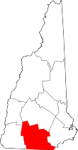 | |
| Towns | ||
| CDPs | ||
| Other villages | ||