Armory Park Historic Residential District
|
Armory Park Historic Residential District | |
|
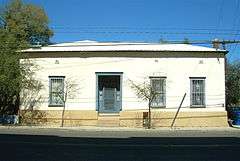
A 19th century adobe house in the Armory Park neighborhood | |
  | |
| Location |
E. 12th St. to 19th St., Stone Ave. to 2nd Ave., (original) |
|---|---|
| Coordinates | 32°12′56″N 110°57′58″W / 32.21556°N 110.96611°WCoordinates: 32°12′56″N 110°57′58″W / 32.21556°N 110.96611°W |
| Built | 1880 |
| Architect | Multiple |
| Architectural style |
Classical Revival, Queen Anne, Mission/Spanish Revival (original) Late Victorian, Late 19th And 20th Century Revivals, Sonoran (increase) |
| NRHP Reference # | 76000378 and 96000754 [1] |
| Added to NRHP |
July 30, 1976 (original) July 05, 1996 (increase) |
Armory Park Historic Residential District is a historic district in Tucson, Arizona. It was listed on the NRHP in 1976 and the district boundaries were increased in 1996.[1]
Part of the eastern section of the Armory Park Historic Residential District, was the former location of company housing for employees of the Southern Pacific Railroad. In 2000, on this land, a solar-powered housing development known as Armory Park del Sol was built and the streets were named in honor of people that lived in the neighborhood or things related to the area. The uniqueness of this housing project, along with the locally themed street names gained enough attention that it was included in the "Street Smarts" column, run in the Arizona Daily Star newspaper.[2]
References
- 1 2 National Park Service (2008-04-15). "National Register Information System". National Register of Historic Places. National Park Service.
- ↑ David Leighton, "Street Smarts: Street names in downtown neighborhood reflect area's history," Arizona Daily Star, December 17, 2013
| Topics | |
|---|---|
| Lists by states |
|
| Lists by insular areas | |
| Lists by associated states | |
| Other areas | |
| |