National Register of Historic Places listings in the Marshall Islands
_(Polynesia_centered).svg.png)
Location of the Marshall Islands in the western Pacific
This is a list of the buildings, sites, districts, and objects listed on the National Register of Historic Places in the Marshall Islands. There are currently 4 listed sites located in only three of the 24 atolls that make up the Marshall Islands.
- This National Park Service list is complete through NPS recent listings posted December 16, 2016.[1]
Listings
| [2] | Name on the Register | Image | Date listed[3] | Location | Atoll | Description |
|---|---|---|---|---|---|---|
| 1 | Debrum House | Upload image | (#76002160) |
Likiep Island 9°49′21″N 169°18′23″E / 9.8225°N 169.306389°E |
Likiep | |
| 2 | Kwajalein Island Battlefield |  |
(#85001757) |
Kwajalein Missile Range 8°43′08″N 167°43′55″E / 8.718889°N 167.731944°E |
Kwajalein | This landmark district encompasses the entire bounds of Kwajalein Island at the time of the 1944 Battle of Kwajalein. (The island has since changed in size due to dredging and filling projects.) |
| 3 | Marshall Islands War Memorial Park | Upload image | (#76002194) |
Dalap Island 7°05′09″N 171°22′18″E / 7.085833°N 171.371667°E |
Majuro | |
| 4 | Roi-Namur Battlefield | 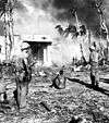 |
(#85001758) |
Kwajalein Missile Range 9°23′44″N 167°28′33″E / 9.395417°N 167.475833°E |
Kwajalein | This landmark district encompasses the entire island of Roi-Namur. |
See also
References
- ↑ "National Register of Historic Places: Weekly List Actions". National Park Service, United States Department of the Interior. Retrieved on December 16, 2016.
- ↑ Numbers represent an ordering by significant words. Various colorings, defined here, differentiate National Historic Landmarks and historic districts from other NRHP buildings, structures, sites or objects.
- ↑ The eight-digit number below each date is the number assigned to each location in the National Register Information System database, which can be viewed by clicking the number.
External links
 Media related to National Register of Historic Places in the Marshall Islands at Wikimedia Commons
- National Park Service, National Register of Historic Places Program
| Topics | |
|---|---|
| Lists by states |
|
| Lists by insular areas | |
| Lists by associated states | |
| Other areas | |
| |
| ||
| Ratak Chain (Sunrise, Eastern) |  | |
| Ralik Chain (Sunset, Western) | ||
This article is issued from Wikipedia - version of the 12/22/2014. The text is available under the Creative Commons Attribution/Share Alike but additional terms may apply for the media files.
