| [4] |
Name on the Register |
Image |
Date listed[5] |
Location |
Village |
Description |
|---|
| 1 |
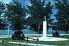
Banzai Cliff |
|
000000001976-08-27-0000August 27, 1976
(#76002192) |
Bandero, Magpi area
15°17′17″N 145°48′58″E / 15.288056°N 145.816111°E / 15.288056; 145.816111 (Banzai Cliff) |
San Roque |
|
| 2 |
Brown Beach One Japanese Fortifications |
Upload image |
000000002007-02-28-0000February 28, 2007
(#07000123) |
Unai Laolao Kattan (North Laolao Beach) along the east coast of Saipan
15°10′33″N 145°47′05″E / 15.175833°N 145.784722°E / 15.175833; 145.784722 (Brown Beach One Japanese Fortifications) |
Unai Laolao Kattan |
|
| 3 |
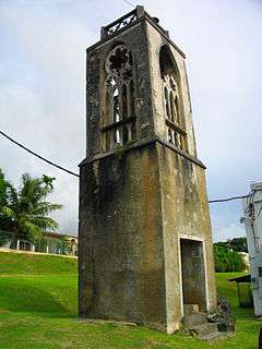
Campaneyan Kristo Rai |
|
000000001984-10-30-0000October 30, 1984
(#84000207) |
Beach Road
15°12′11″N 145°43′04″E / 15.203056°N 145.717778°E / 15.203056; 145.717778 (Campaneyan Kristo Rai) |
Garapan |
Spanish-built 1932 church bell tower
|
| 4 |
Chalan Galaide |
Upload image |
000000001987-10-04-0000October 4, 1987
(#87001559) |
Address Restricted
|
Garapan |
|
| 5 |
Hachiman Jinja |
Upload image |
000000002003-06-21-0000June 21, 2003
(#03000549) |
Lot numbers H 300-11 and H 300-4
15°10′44″N 145°45′40″E / 15.178889°N 145.761111°E / 15.178889; 145.761111 (Hachiman Jinja) |
Kannat Taddong Papago |
|
| 6 |
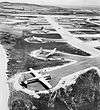
Isley Field Historic District |
|
000000001981-06-26-0000June 26, 1981
(#81000667) |
Saipan International Airport
15°07′20″N 145°43′58″E / 15.122222°N 145.732778°E / 15.122222; 145.732778 (Isley Field Historic District) |
Chalan Kanoa |
World War II airfield, now the island's main airport
|
| 7 |
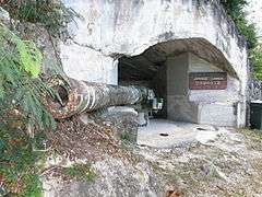
Japanese 20mm Cannon Blockhouse |
Upload image |
000000001995-08-25-0000August 25, 1995
(#95001048) |
Northwest of Punton Opyan
15°06′46″N 145°42′17″E / 15.112778°N 145.704722°E / 15.112778; 145.704722 (Japanese 20mm Cannon Blockhouse) |
Saipan Island |
|
| 8 |
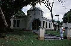
Japanese Hospital |
|
000000001974-12-19-0000December 19, 1974
(#74002189) |
Route 3
15°12′06″N 145°43′08″E / 15.201667°N 145.718889°E / 15.201667; 145.718889 (Japanese Hospital) |
Garapan |
|
| 9 |
Japanese Jail Historic and Archeological District |
|
000000002011-04-08-0000April 8, 2011
(#10001017) |
Chichirica Avenue and Ghiyobw Street
15°21′01″N 145°43′08″E / 15.350278°N 145.71875°E / 15.350278; 145.71875 (Japanese Jail Historic and Archeological District) |
Garapan |
|
| 10 |
Japanese Lighthouse |
|
000000001974-12-19-0000December 19, 1974
(#74002224) |
Navy Hill
15°12′42″N 145°43′54″E / 15.211722°N 145.731639°E / 15.211722; 145.731639 (Japanese Lighthouse) |
Garapan |
|
| 11 |
Landing Beaches, Aslito-Isley Field and Marpi Point |
|
000000001985-02-04-0000February 4, 1985
(#85001789) |
Saipan International Airport and Beaches
15°06′55″N 145°43′01″E / 15.115278°N 145.716944°E / 15.115278; 145.716944 (Landing Beaches, Aslito-Isley Field and Marpi Point) |
Chalan Kanoa |
|
| 12 |
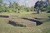
Laulau Kattan Latte Site |
|
000000002000-10-30-0000October 30, 2000
(#00001212) |
Address Restricted
|
Kagman III Homestead |
|
| 13 |
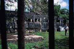
Managaha Island Historic District |
|
000000001984-11-05-0000November 5, 1984
(#84000425) |
West of Saipan
15°14′29″N 145°42′45″E / 15.241389°N 145.7125°E / 15.241389; 145.7125 (Managaha Island Historic District) |
Garapan |
|
| 14 |
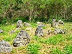
Sabanetan Toro Latte Site |
Upload image |
000000001984-11-08-0000November 8, 1984
(#84000731) |
Address Restricted
|
Garapan |
|
| 15 |
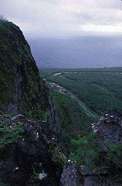
Suicide Cliff |
|
000000001976-09-30-0000September 30, 1976
(#76002193) |
Bandero
15°16′38″N 145°48′35″E / 15.277222°N 145.809722°E / 15.277222; 145.809722 (Suicide Cliff) |
San Roque |
|
| 16 |
Tachognya |
Upload image |
000000001986-02-13-0000February 13, 1986
(#86000235) |
Address Restricted
|
San Jose |
|
| 17 |
Unai Achugao Archaeological Site |
Upload image |
000000001996-08-08-0000August 8, 1996
(#96000825) |
Address Restricted
|
Punton Achugao |
|
| 18 |
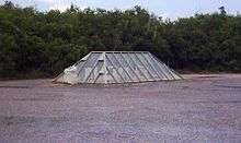
Unai Lagua Japanese Defense Pillbox |
Upload image |
000000001984-06-01-0000June 1, 1984
(#84002777) |
Unai Lagua
15°16′25″N 145°49′42″E / 15.273611°N 145.828333°E / 15.273611; 145.828333 (Unai Lagua Japanese Defense Pillbox) |
San Roque |
|
| 19 |
Unai Obyan Latte Site |
Upload image |
000000001985-02-05-0000February 5, 1985
(#85000244) |
Address Restricted
|
Chalan Kanoa |
|
| 20 |
Waherak Maihar |
Upload image |
000000001978-01-31-0000January 31, 1978
(#78003081) |
Public Works Headquarters Compound
Coordinates missing |
Chalan Kanoa |
A traditionally-built outrigger canoe. |