National Register of Historic Places listings in Kentucky

This is a list of properties and historic districts in Kentucky that are listed on the National Register of Historic Places. There are listings in all of Kentucky's 120 counties.
The locations of National Register properties and districts (at least for all showing latitude and longitude coordinates below), may be seen in an online map by clicking on "Map of all coordinates".[1]
- This National Park Service list is complete through NPS recent listings posted December 16, 2016.[2]
- Adair
- Allen
- Anderson
- Ballard
- Barren
- Bath
- Bell
- Boone
- Bourbon
- Boyd
- Boyle
- Bracken
- Breckinridge
- Breathitt
- Bullitt
- Butler
- Caldwell
- Calloway
- Campbell
- Carlisle
- Carroll
- Carter
- Casey
- Christian
- Clark
- Clay
- Clinton
- Crittenden
- Cumberland
- Daviess
- Edmonson
- Elliott
- Estill
- Fayette
- Fleming
- Floyd
- Franklin
- Fulton
- Gallatin
- Garrard
- Grant
- Graves
- Grayson
- Green
- Greenup
- Hancock
- Hardin
- Harlan
- Harrison
- Hart
- Henderson
- Henry
- Hickman
- Hopkins
- Jackson
- Jefferson
- Jessamine
- Johnson
- Kenton
- Knott
- Knox
- LaRue
- Laurel
- Lawrence
- Lee
- Leslie
- Letcher
- Lewis
- Lincoln
- Livingston
- Logan
- Lyon
- Madison
- Magoffin
- Marion
- Marshall
- Martin
- Mason
- McCracken
- McCreary
- McLean
- Meade
- Menifee
- Mercer
- Metcalfe
- Monroe
- Montgomery
- Morgan
- Muhlenberg
- Nelson
- Nicholas
- Ohio
- Oldham
- Owen
- Owsley
- Pendleton
- Perry
- Pike
- Powell
- Pulaski
- Robertson
- Rockcastle
- Rowan
- Russell
- Scott
- Shelby
- Simpson
- Spencer
- Taylor
- Todd
- Trigg
- Trimble
- Union
- Warren
- Washington
- Wayne
- Webster
- Whitley
- Wolfe
- Woodford
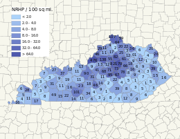
Current listings by county
The following are approximate tallies of current listings by county. These counts are based on entries in the National Register Information Database as of April 24, 2008[3] and new weekly listings posted since then on the National Register of Historic Places web site.[4] There are frequent additions to the listings and occasional delistings and the counts here are approximate and not official. New entries are added to the official Register on a weekly basis.[5] Also, the counts in this table exclude boundary increase and decrease listings which only modify the area covered by an existing property or district, although carrying a separate National Register reference number.


See also
- List of National Historic Landmarks in Kentucky
- List of bridges on the National Register of Historic Places in Kentucky
References
- ↑ The latitude and longitude information provided in this table was derived originally from the National Register Information System, which has been found to be fairly accurate for about 99% of listings. For about 1% of NRIS original coordinates, experience has shown that one or both coordinates are typos or otherwise extremely far off; some corrections may have been made. A more subtle problem causes many locations to be off by up to 150 yards, depending on location in the country: most NRIS coordinates were derived from tracing out latitude and longitudes off of USGS topographical quadrant maps created under the North American Datum of 1927, which differs from the current, highly accurate WGS84 GPS system used by most on-line maps. Chicago is about right, but NRIS longitudes in Washington are higher by about 4.5 seconds, and are lower by about 2.0 seconds in Maine. Latitudes differ by about 1.0 second in Florida. Some locations in this table may have been corrected to current GPS standards.
- ↑ "National Register of Historic Places: Weekly List Actions". National Park Service, United States Department of the Interior. Retrieved on December 16, 2016.
- ↑ National Park Service (2008-04-24). "National Register Information System". National Register of Historic Places. National Park Service.
- ↑ "National Register of Historic Places: Weekly List Actions". National Park Service. Retrieved February 13, 2009.
- ↑ Weekly List Actions, National Register of Historic Places website
- ↑ The following sites are listed in multiple counties: Battle of Mill Springs Historic Areas (Pulaski and Wayne), Boone Creek Rural Historic District (Clark and Fayette), Cumberland Gap National Historical Park (Bell and Harlan), East Main Street Bridge (Knox and Whitley), Falls of Rough Historic District (Breckinridge and Grayson), Lexington Extension of the Louisville Southern Railroad (Anderson and Woodford), Lower Shawneetown Archeological District (Greenup and Lewis), Middle Reaches of Boone Creek Rural Historic District (Clark and Fayette), Mitchell-Estes Farmstead (Edmonson and Warren), New Zion Historic District (Fayette and Scott), Owen-Gay Farm (Bourbon and Clark), Pisgah Rural Historic District (Fayette and Woodford), Redd Road Rural Historic District (Fayette and Woodford), Salts Cave Archeological Site (Edmonson and Hart), and Weisenberger Mills and Related Buildings (Scott and Woodford).
| Wikimedia Commons has media related to National Register of Historic Places in Kentucky. |
| Topics | |
|---|---|
| Lists by states |
|
| Lists by insular areas | |
| Lists by associated states | |
| Other areas | |
| |
Frankfort (capital) | ||
| Topics | ||
| Society | ||
| Regions | ||
| 25 largest cities | ||
| Metropolitan areas | ||
| Counties |
| |
