National Register of Historic Places listings in Iowa

This is a list of properties and historic districts in Iowa that are listed on the National Register of Historic Places. There are listings in all of Iowa's 99 counties, adding up to over 2,200 total.
- This National Park Service list is complete through NPS recent listings posted December 2, 2016.[1]
Current listings by county
The following are approximate tallies of current listings by county. These counts are based on entries in the National Register Information Database as of April 24, 2008[2] and new weekly listings posted since then on the National Register of Historic Places web site.[3] There are frequent additions to the listings and occasional delistings and the counts here are approximate and not official. New entries are added to the official Register on a weekly basis.[4] Also, the counts in this table exclude boundary increase and decrease listings which modify the area covered by an existing property or district and which carry a separate National Register reference number. The numbers of NRHP listings in each county are documented by tables in each of the individual county list-articles.


| County | # of Sites | |
|---|---|---|
| 1 | Adair | 9 |
| 2 | Adams | 5 |
| 3 | Allamakee | 21 |
| 4 | Appanoose | 13 |
| 5 | Audubon | 14 |
| 6 | Benton | 16 |
| 7 | Black Hawk | 44 |
| 8 | Boone | 18 |
| 9 | Bremer | 11 |
| 10 | Buchanan | 19 |
| 11 | Buena Vista | 9 |
| 12 | Butler | 7 |
| 13 | Calhoun | 12 |
| 14 | Carroll | 14 |
| 15 | Cass | 11 |
| 16 | Cedar | 17 |
| 17 | Cerro Gordo | 43 |
| 18 | Cherokee | 9 |
| 19 | Chickasaw | 4 |
| 20 | Clarke | 7 |
| 21 | Clay | 9 |
| 22 | Clayton | 54 |
| 23 | Clinton | 30 |
| 24 | Crawford | 14 |
| 25 | Dallas | 15 |
| 26 | Davis | 12 |
| 27 | Decatur | 7 |
| 28 | Delaware | 15 |
| 29 | Des Moines | 32 |
| 30 | Dickinson | 12 |
| 31 | Dubuque | 80 |
| 32 | Emmet | 3 |
| 33 | Fayette | 28 |
| 34 | Floyd | 19 |
| 35 | Franklin | 12 |
| 36 | Fremont | 9 |
| 37 | Greene | 17 |
| 38 | Grundy | 2 |
| 39 | Guthrie | 7 |
| 40 | Hamilton | 8 |
| 41 | Hancock | 9 |
| 42 | Hardin | 35 |
| 43 | Harrison | 13 |
| 44 | Henry | 51 |
| 45 | Howard | 8 |
| 46 | Humboldt | 7 |
| 47 | Ida | 5 |
| 48 | Iowa | 11 |
| 49 | Jackson | 75 |
| 50 | Jasper | 13 |
| 51 | Jefferson | 29 |
| 52 | Johnson | 87 |
| 53 | Jones | 29 |
| 54 | Keokuk | 9 |
| 55 | Kossuth | 6 |
| 56 | Lee | 45 |
| 57 | Linn | 94 |
| 58 | Louisa | 8 |
| 59 | Lucas | 16 |
| 60 | Lyon | 10 |
| 61 | Madison | 48 |
| 62 | Mahaska | 46 |
| 63 | Marion | 26 |
| 64 | Marshall | 15 |
| 65 | Mills | 6 |
| 66 | Mitchell | 10 |
| 67 | Monona | 10 |
| 68 | Monroe | 11 |
| 69 | Montgomery | 17 |
| 70 | Muscatine | 29 |
| 71 | O'Brien | 3 |
| 72 | Osceola | 1 |
| 73 | Page | 9 |
| 74 | Palo Alto | 4 |
| 75 | Plymouth | 12 |
| 76 | Pocahontas | 3 |
| 77 | Polk | 182 |
| 78 | Pottawattamie | 37 |
| 79 | Poweshiek | 24 |
| 80 | Ringgold | 6 |
| 81 | Sac | 12 |
| 82.1 | Scott: Davenport: Downtown | 54 |
| 82.2 | Scott: Davenport: East | 88 |
| 82.3 | Scott: Davenport: West | 108 |
| 82.4 | Scott: Davenport: Duplicates | (1)[5] |
| 82.5 | Scott: Other | 32 |
| 82.6 | Scott: Total | 281 |
| 83 | Shelby | 12 |
| 84 | Sioux | 4 |
| 85 | Story | 35 |
| 86 | Tama | 12 |
| 87 | Taylor | 7 |
| 88 | Union | 6 |
| 89 | Van Buren | 20 |
| 90 | Wapello | 30 |
| 91 | Warren | 12 |
| 92 | Washington | 18 |
| 93 | Wayne | 3 |
| 94 | Webster | 14 |
| 95 | Winnebago | 3 |
| 96 | Winneshiek | 32 |
| 97 | Woodbury | 55 |
| 98 | Worth | 6 |
| 99 | Wright | 9 |
| (duplicates) | (4)[6] | |
| Total: | 2,314 | |
Adair County
Adams County
| [7] | Name on the Register | Image | Date listed[8] | Location | City or town | Description |
|---|---|---|---|---|---|---|
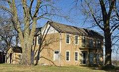
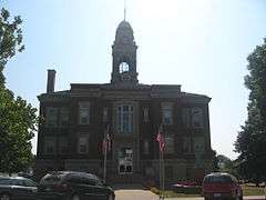
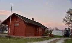
| 1 | Adams County Jail | 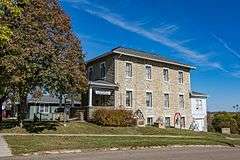 |
(#91000119) |
1000 Benton Ave. 40°59′32″N 94°44′04″W / 40.992222°N 94.734444°W |
Corning | |
| 2 | Corning Commercial Historic District | Upload image | (#12000318) |
513-824 Davis Ave., 701-829 Benton Ave. & cross streets 40°59′21″N 94°44′05″W / 40.989066°N 94.734809°W |
Corning | |
| 3 | Corning Opera House | Upload image | (#93000954) |
800 Davis Ave. 40°59′25″N 94°44′01″W / 40.990278°N 94.733611°W |
Corning | |
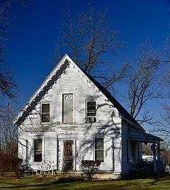
| 4 | Noah Odell House |  |
(#00000917) |
1245 240th St. 40°57′35″N 94°50′45″W / 40.959722°N 94.845833°W |
Nodaway | |
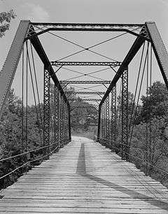
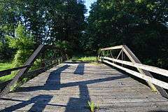
| 5 | Snider Bridge | 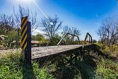 |
(#98000774) |
220th St. over an unnamed stream 40°59′28″N 94°36′38″W / 40.991111°N 94.610556°W |
Corning |
Allamakee County
Appanoose County
Audubon County
Benton County
Black Hawk County
Boone County
Bremer County
Buchanan County
Buena Vista County
Butler County
Calhoun County
Carroll County
Cass County
Cedar County
Cerro Gordo County
Cherokee County
Chickasaw County
| [7] | Name on the Register | Image | Date listed[8] | Location | City or town | Description |
|---|---|---|---|---|---|---|
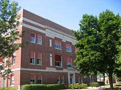
| 1 | Chickasaw County Courthouse | 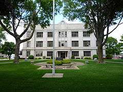 |
(#81000228) |
Prospect St. at Locust Ave. 43°09′36″N 92°18′49″W / 43.16°N 92.313611°W |
New Hampton | |
| 2 | Chickasaw Octagon House | Upload image | (#79000888) |
Court St. 43°02′11″N 92°29′58″W / 43.036389°N 92.499444°W |
Chickasaw Township | |
| 3 | George Darrow Round Barn | Upload image | (#86001421) |
County Road T76 43°09′52″N 92°29′46″W / 43.164444°N 92.496111°W |
Alta Vista | |
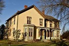
| 4 | John Foley House | Upload image | (#79000889) |
511 N. Locust St. 43°03′52″N 92°18′49″W / 43.064444°N 92.313611°W |
New Hampton |
Clarke County
Former listing
| [7] | Name on the Register | Image | Date listed | Date removed | Location | City or town | Summary |
|---|---|---|---|---|---|---|---|
| 1 | Brady-Bolibaugh House | Upload image | (#85000003) | 217 W. Washington 41°02′12″N 93°45′45″W / 41.036667°N 93.7625°W |
Osceola |
Clay County
Clayton County
Clinton County
Crawford County
Dallas County
Davis County
Decatur County

Delaware County
Des Moines County
Dickinson County
Dubuque County
Emmet County
| [7] | Name on the Register | Image | Date listed[8] | Location | City or town | Description |
|---|---|---|---|---|---|---|
| 1 | Brugjeld-Peterson Family Farmstead District | 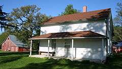 |
(#00000326) |
2349 450th Ave. 43°18′17″N 94°42′02″W / 43.304722°N 94.700556°W |
Wallingford | |
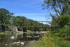
| 2 | Ellsworth Ranch Bridge | 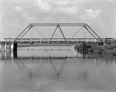 |
(#98000869) |
130th St. over the East Fork of the Des Moines River 43°27′36″N 94°34′49″W / 43.46°N 94.580278°W |
Armstrong | |
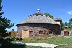
| 3 | Thomsen Round Barn | Upload image | (#86001426) |
Off Iowa Highway 15 43°20′46″N 94°29′52″W / 43.346111°N 94.497778°W |
Armstrong |
Fayette County
Floyd County
Franklin County
Fremont County
Greene County
Grundy County
| [7] | Name on the Register | Image | Date listed[8] | Location | City or town | Description |
|---|---|---|---|---|---|---|
| 1 | Grundy County Courthouse | 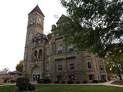 |
(#81000239) |
Grundy Ave. 42°21′31″N 92°46′18″W / 42.358611°N 92.771667°W |
Grundy Center | |
| 2 | Chris Neessen House | Upload image | (#84001253) |
601 E. 4th 42°26′04″N 92°55′29″W / 42.434444°N 92.924722°W |
Wellsburg |
Guthrie County
Former listings
| [7] | Name on the Register | Image | Date listed | Date removed | Location | City or town | Summary |
|---|---|---|---|---|---|---|---|
| 1 | Panora-Linden High School | Upload image | (#74000786) | Bounded by Main, Market, 1st, and 2nd Sts. |
Panora | Torn down in 1991[9] |
Hamilton County
Hancock County
Hardin County
Harrison County
Henry County
Howard County

Humboldt County
.jpg)


Ida County
| [7] | Name on the Register | Image | Date listed[8] | Location | City or town | Description |
|---|---|---|---|---|---|---|
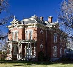
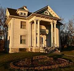
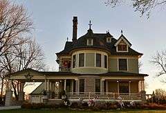
| 1 | Alvin Bushnell Bell House | Upload image | (#83000369) |
310 Quimby St. 42°20′37″N 95°28′27″W / 42.343611°N 95.474167°W |
Ida Grove | Designed by architect George Franklin Barber |
| 2 | Ida County Courthouse |  |
(#74000787) |
401 Moorehead St. 42°20′31″N 95°28′04″W / 42.342023°N 95.467650°W |
Ida Grove | |
| 3 | Moorehead Stagecoach Inn | Upload image | (#74000788) |
Off U.S. Route 59 42°21′15″N 95°28′44″W / 42.354167°N 95.478889°W |
Ida Grove | |
| 4 | Dr. Francis B. Warnock House | Upload image | (#88001945) |
201 Maple St. 42°18′57″N 95°36′02″W / 42.315806°N 95.600637°W |
Battle Creek | Designed by architect George Franklin Barber |
| 5 | Waveland Round Barn | Upload image | (#86001438) |
Off U.S. Route 20 42°29′46″N 95°42′09″W / 42.496111°N 95.7025°W |
Cushing |
Former listings
| [7] | Name on the Register | Image | Date listed | Date removed | Location | City or town | Summary |
|---|---|---|---|---|---|---|---|
| 1 | Turner Hall | Upload image | (#75000691) | SE corner of Keil and 2nd Streets |
Holstein |
Iowa County
Jackson County
Jasper County
Jefferson County
Johnson County
Jones County
Keokuk County
Kossuth County
Former listings
| [7] | Name on the Register | Image | Date listed | Date removed | Location | City or town | Summary |
|---|---|---|---|---|---|---|---|
| 1 | Longbottom Polygonal Barn | Upload image | (#86001456) | Off Iowa Highway 226 |
Titonka |
Lee County
Linn County
Louisa County

Former listing
| [7] | Name on the Register | Image | Date listed | Date removed | Location | City or town | Summary |
|---|---|---|---|---|---|---|---|
| 1 | Judge Francis Springer House | Upload image | (#83000388) | South of Columbus City |
Columbus City | Burned by owner in October 1997.[12] |
Lucas County
Lyon County
Madison County
Mahaska County
Marion County
Marshall County
Mills County
| [7] | Name on the Register | Image | Date listed[8] | Location | City or town | Description |
|---|---|---|---|---|---|---|
| 1 | Davis Oriole Earthlodge Site |  |
(#12001018) |
in Pony Creek Park 41°04′15″N 95°47′17″W / 41.070780°N 95.787957°W |
Glenwood vicinity | |
| 2 | Glenwood Archeological District | 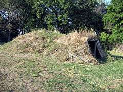 |
(#13000296) |
Address Restricted |
Glenwood | part of the Archeological Resources of the Central Plains Tradition in the Loess Hills Region of Iowa MPS |
| 3 | Nishnabotna River Bridge | Upload image | (#98000496) |
County Road M16 over the Nishnabotna River north of Henderson 41°05′21″N 95°28′49″W / 41.089167°N 95.480278°W |
Anderson Township | |
| 4 | Plattsmouth Bridge | 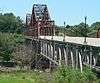 |
(#92000755) |
U.S. Route 34 over the Missouri River southwest of Pacific Junction 41°00′03″N 95°52′01″W / 41.00096°N 95.866836°W |
Plattville Township | Extends into Cass County, Nebraska |
| 5 | Pony Creek Park | |
(#71000299) |
Northwest of Glenwood 41°04′16″N 95°47′12″W / 41.071111°N 95.786667°W |
Oak Township | |
| 6 | West Oak Forest Earthlodge Site |  |
(#10000342) |
Rural (Address Restricted) |
Glenwood vicinity | part of the Archeological Resources of the Central Plains Tradition in the Loess Hills Region of Iowa MPS |
Mitchell County
Monona County
Monroe County
Montgomery County
Muscatine County
O'Brien County
| [7] | Name on the Register | Image | Date listed[8] | Location | City or town | Description |
|---|---|---|---|---|---|---|
| 1 | Carnegie Library | 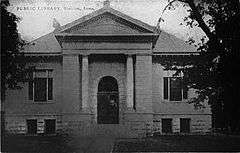 |
(#77001504) |
321 10th St. 43°10′47″N 95°51′14″W / 43.179722°N 95.853889°W |
Sheldon | |
| 2 | Indian Village Site | 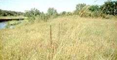 |
(#66000888) |
Left bank of Waterman Creek, east of Sutherland[13] 42°58′50″N 95°25′22″W / 42.980556°N 95.422778°W |
Sutherland | |
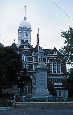
| 3 | O'Brien County Courthouse | 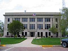 |
(#81000656) |
Fir Ave. 43°05′12″N 95°37′38″W / 43.086667°N 95.627222°W |
Primghar |
Osceola County
| [7] | Name on the Register | Image | Date listed[8] | Location | City or town | Description |
|---|---|---|---|---|---|---|
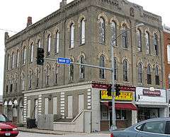
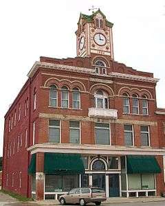
| 1 | Osceola County Courthouse | .JPG) |
(#81000261) |
3rd Ave. and 8th St. 43°24′07″N 95°44′51″W / 43.401944°N 95.7475°W |
Sibley |
Page County
Palo Alto County
| [7] | Name on the Register | Image | Date listed[8] | Location | City or town | Description |
|---|---|---|---|---|---|---|
| 1 | Emmetsburg Public Library | 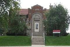 |
(#83000397) |
10th St. on Courthouse Sq. 43°05′19″N 94°41′52″W / 43.088611°N 94.697778°W |
Emmetsburg | |
| 2 | First Presbyterian Church | Upload image | (#10000276) |
101 1st Ave. SW 42°57′35″N 94°26′47″W / 42.959683°N 94.446417°W |
West Bend | |
| 3 | Grotto of the Redemption | |
(#00001679) |
300 N. Broadway 42°57′50″N 94°26′44″W / 42.963889°N 94.445556°W |
West Bend | |
| 4 | Ormsby-Kelly House | Upload image | (#77000545) |
2403 W. 7th St. 43°06′46″N 94°41′02″W / 43.112778°N 94.683889°W |
Emmetsburg |
Plymouth County
Pocahontas County
| [7] | Name on the Register | Image | Date listed[8] | Location | City or town | Description |
|---|---|---|---|---|---|---|
| 1 | Laurens Carnegie Free Library | .png) |
(#74000804) |
263 N. 3rd St. 42°50′54″N 94°50′56″W / 42.848333°N 94.848889°W |
Laurens | |
| 2 | Pocahontas County Courthouse | 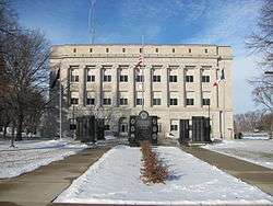 |
(#81000264) |
Court Sq. 42°44′14″N 94°40′07″W / 42.737222°N 94.668611°W |
Pocahontas | |
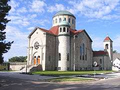
| 3 | Saints Peter and Paul Catholic Church | 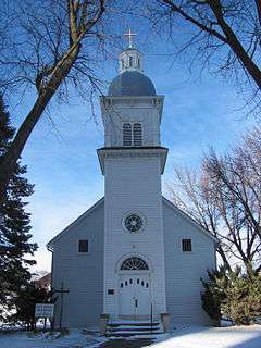 |
(#94000086) |
16 2nd Ave., NW. 42°44′05″N 94°40′15″W / 42.734722°N 94.670833°W |
Pocahontas |
Polk County
Pottawattamie County
Poweshiek County
Ringgold County
Sac County
Scott County
Shelby County
Sioux County
| [7] | Name on the Register | Image | Date listed[8] | Location | City or town | Description |
|---|---|---|---|---|---|---|
| 1 | Charles M. and Emma M. Fischer Fleshman House | Upload image | (#92001743) |
919 9th St. 42°59′44″N 96°28′52″W / 42.995556°N 96.481111°W |
Hawarden | |
| 2 | Hawarden City Hall, Fire Station and Auditorium | Upload image | (#09000107) |
715 Central Ave. 42°59′39″N 96°29′08″W / 42.994167°N 96.485556°W |
Hawarden | |
| 3 | Sioux County Courthouse | 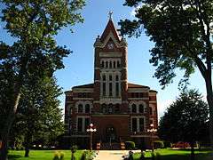 |
(#77000559) |
Off Iowa Highway 10 43°00′16″N 96°03′32″W / 43.004557°N 96.058889°W |
Orange City | |
| 4 | Zwemer Hall, Northwestern College |  |
(#75000698) |
101 7th St., SW. 42°59′53″N 96°03′30″W / 42.997963°N 96.058306°W |
Orange City |
Story County
Tama County
Taylor County
Union County
| [7] | Name on the Register | Image | Date listed[8] | Location | City or town | Description |
|---|---|---|---|---|---|---|
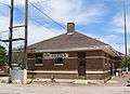
| 1 | Chicago, Burlington and Quincy Railroad-Creston Station | 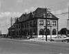 |
(#73000739) |
200 W. Adams St. 41°03′25″N 94°21′45″W / 41.056944°N 94.3625°W |
Creston | |
| 2 | Grand River Bridge | Upload image | (#98000479) |
230th St. over the Grand River 40°57′48″N 94°02′20″W / 40.963333°N 94.038889°W |
Arispe | |
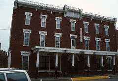
| 3 | Iowana Hotel | 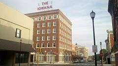 |
(#09000298) |
203 W. Montgomery St. 41°03′31″N 94°21′47″W / 41.058611°N 94.363056°W |
Creston | |
| 4 | Jefferson Elementary School |  |
(#02001223) |
501 North Cherry 41°03′45″N 94°21′23″W / 41.0625°N 94.356389°W |
Creston | |
| 5 | Odd Fellows Block | Upload image | (#13001079) |
175 E. Kansas St. 41°01′42″N 94°11′49″W / 41.028224°N 94.196845°W |
Afton | |
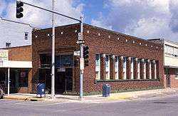
| 6 | U.S. Post Office | 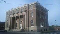 |
(#78001264) |
Maple St. 41°03′34″N 94°21′46″W / 41.059444°N 94.362778°W |
Creston |
Van Buren County
Wapello County
Warren County
Washington County
Wayne County
| [7] | Name on the Register | Image | Date listed[8] | Location | City or town | Description |
|---|---|---|---|---|---|---|
| 1 | Nelson Round Barn | Upload image | (#86003189) |
County Road J46 40°42′24″N 93°20′44″W / 40.706667°N 93.345556°W |
Allerton | |
| 2 | Pleasant Hill School | Upload image | (#75000701) |
3 miles north of Lineville on U.S. Route 65 40°37′26″N 93°29′48″W / 40.623889°N 93.496667°W |
Lineville | |
| 3 | W.H. Tedford House | Upload image | (#79000947) |
312 S. West St. 40°45′25″N 93°19′24″W / 40.756944°N 93.323333°W |
Corydon |
Webster County
Winnebago County
| [7] | Name on the Register | Image | Date listed[8] | Location | City or town | Description |
|---|---|---|---|---|---|---|
| 1 | Round Barn, Norway Township | Upload image | (#87000507) |
Off County Road R60 43°29′22″N 93°35′51″W / 43.489444°N 93.5975°W |
Norway Township | |
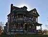
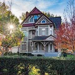
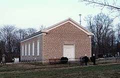
| 2 | Charles J. Thompson House | 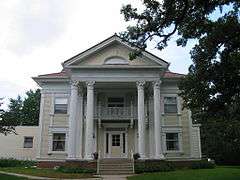 |
(#78001271) |
336 N. Clark St. 43°15′58″N 93°38′18″W / 43.266111°N 93.638333°W |
Forest City | |
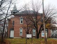
| 3 | Winnebago County Courthouse |  |
(#81000275) |
J St. 43°15′47″N 93°38′19″W / 43.263056°N 93.638611°W |
Forest City |
Former listings
| [7] | Name on the Register | Image | Date listed | Date removed | Location | City or town | Summary |
|---|---|---|---|---|---|---|---|
| 1 | Forest City Public Library | Upload image | (#84001609) | E. I St. and Clark 43°15′56″N 93°38′15″W / 43.265556°N 93.6375°W |
Forest City |
Winneshiek County
Woodbury County
Worth County

Wright County
See also
| Wikimedia Commons has media related to National Register of Historic Places in Iowa. |
References
- ↑ "National Register of Historic Places: Weekly List Actions". National Park Service, United States Department of the Interior. Retrieved on December 2, 2016.
- ↑ National Park Service (2008-04-24). "National Register Information System". National Register of Historic Places. National Park Service.
- ↑ "National Register of Historic Places: Weekly List Actions". National Park Service. Retrieved January 2, 2009.
- ↑ Weekly List Actions, National Register of Historic Places website
- ↑ The Vander Veer Park Historic District is split between east and west Davenport.
- ↑ Effigy Mounds National Monument is split between Allamakee and Clayton counties; Le Grand Bridge (1896) is split between Marshall and Tama counties; County Line Bridge is split between Louisa and Washington counties; Bridgeport Bridge is split between Des Moines and Lee counties
- 1 2 3 4 5 6 7 8 9 10 11 12 13 14 15 16 17 18 19 20 21 22 23 24 25 26 27 28 29 30 31 32 Numbers represent an ordering by significant words. Various colorings, defined here, differentiate National Historic Landmarks and historic districts from other NRHP buildings, structures, sites or objects.
- 1 2 3 4 5 6 7 8 9 10 11 12 13 14 15 16 17 18 19 20 21 22 23 24 25 26 The eight-digit number below each date is the number assigned to each location in the National Register Information System database, which can be viewed by clicking the number.
- ↑
- ↑ Springer, Arthur. History of Louisa County Iowa From Its Earliest Settlement to 1912. Vol. 1. Chicago: Clarke, 1912, 13.
- ↑ Address derived from this Louisa County Conservation Board page; the NRIS lists the site as "Address Restricted".
- ↑
- ↑ Vis, Robert B., and Dale R. Henning. "A Local Sequence for Mill Creek Sites in the Little Sioux River Valley". Plains Anthropologist 14.46 (1969): 253-271: 254.


| Topics | |
|---|---|
| Lists by states |
|
| Lists by insular areas | |
| Lists by associated states | |
| Other areas | |
| |