Ashburys railway station
- This article refers to the ex Great Central Railway station in Manchester; for the similarly named former LSWR station in Devon see Ashbury railway station.
| Ashburys | |
|---|---|
|
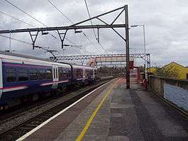
Ashburys railway station in Manchester. The train shown is a Northern Rail Class 323 in First North Western livery. | |
| Location | |
| Place | Openshaw |
| Local authority | Manchester |
| Grid reference | SJ871972 |
| Operations | |
| Station code | ABY |
| Managed by | Northern |
| Number of platforms | 2 |
| DfT category | F2 |
|
Live arrivals/departures, station information and onward connections from National Rail Enquiries | |
| Annual rail passenger usage* | |
| 2010/11 |
|
| 2011/12 |
|
| 2012/13 |
|
| 2013/14 |
|
| 2014/15 |
|
| History | |
| July 1855 | Station opens as Ashbury's |
| November 1855 | Station renamed Ashbury's for Openshaw |
| August 1856 | Station renamed Ashbury's for Belle View |
| National Rail – UK railway stations | |
| * Annual estimated passenger usage based on sales of tickets in stated financial year(s) which end or originate at Ashburys from Office of Rail and Road statistics. Methodology may vary year on year. | |
|
| |
Ashburys railway station in Openshaw, Manchester, England, is on the Manchester-Glossop Line at its junction with the branch line to Romiley and New Mills Central, and the freight-only line to Phillips Park Junction on the Huddersfield Line. It is the nearest railway station to the City of Manchester Stadium.
History
It was built and opened by the Sheffield, Ashton-Under-Lyne and Manchester Railway on its new line from Manchester Store Street station to Sheffield, opening in 1846. First appearing in Bradshaw's in July, in November it was referred to as "Ashburys for Openshaw", then in August 1856, as "Ashburys for Belle Vue".
It became part of the Manchester, Sheffield and Lincolnshire Railway during mergers in 1847. That line changed its name to the Great Central Railway in 1897. Joining the London, Midland and Scottish Railway during the Grouping of 1923, the station passed on to the London Midland Region of British Railways on nationalisation in 1948.
When Sectorisation was introduced in the 1980s, the station was served by Regional Railways under arrangement with the Greater Manchester PTE until the Privatisation of British Railways.
Station name
There is no actual place of this name near this station. It was named after the Ashbury Railway Carriage and Iron Company Ltd which built it for £175 in 1855. This company flourished from 1841 until 1902 when it moved to Saltley in Birmingham, merging with the Metropolitan Amalgamated Railway Carriage and Wagon Company Ltd. Examples of its rolling stock survive to this day on preserved railways all over the world.
Services
Today, Ashburys is a station with two platforms served by EMU half-hourly trains between Manchester Piccadilly and Hadfield and DMU hourly trains between Piccadilly and New Mills Central.[1] TransPennine Express services frequently pass through the station without stopping. The station is operated by Northern.
Electrification and Signalling
The line was electrified at 25 kV AC on 10 December 1984, replacing the 1500 V DC electrification inaugurated on 14 June 1954 by British Railways as part of the Manchester-Sheffield-Wath scheme via the Woodhead tunnel.[2] There was also a signal box here, which controlled the junctions and various sidings. The signal box, opened in 1906 by the Great Central Railway, closed in 2011, when control was transferred to the Manchester East signalling control centre.[3][4] The new WCML North Rail Operating Centre is located a short distance east of the station, next to the line to Guide Bridge. This opened in 2014 (one of 12 such centres either built or being planned in the UK) and will eventually control signalling across most of the routes across the North West England, including the northern end of the West Coast Main Line and the entire Manchester area network.[5]
Future
Under the Greater Manchester TIF programme, Ashburys would have received improvements. However, despite TIF not going ahead, it is still to receive safety, security and passenger information improvements, when funding can be obtained.
Other long term proposals include the Manchester - Marple Tram Train scheme, which was on a 'reserve list' of TIF schemes. Significant new infrastructure works would be required between Piccadilly and Ashburys station, known as 'Piccadilly Link'. It would be incorporated within a major mixed-use development by Grangefield Estates, known as 'Chancellor Place', around the former Mayfield Station site.
Notes
- ↑ GB eNRT, December 2015-May 2016 Edition, Tables 78 & 79
- ↑ Gillham, J.C., The Age of the Electric Train- Electric Trains in Britain since 1883. Shepperton: Ian Allan, 1988, p. 109.
- ↑ Kay, P. Signalling Atlas and Signal Box Directory. Wallasey: Signalling Record Society, 2010, p.15.
- ↑ Modern Railways, December 2011, p.86.
- ↑ "Network Rail reveals record investment in the railway in the West Midlands and North WestNetwork Rail press release 12 June 2014; Retrieved 1 April 2016
References
- Radford, B., (1988) Midland Though The Peak Unicorn Books
- Butt, R. V. J. (1995). The Directory of Railway Stations: details every public and private passenger station, halt, platform and stopping place, past and present (1st ed.). Sparkford: Patrick Stephens Ltd. ISBN 1-8526-0508-1. OCLC 60251199.
- Jowett, Alan (2000). Jowett's Nationalised Railway Atlas (1st ed.). Penryn, Cornwall: Atlantic Transport Publishers. ISBN 0-9068-9999-0. OCLC 228266687.
- Station on navigable O. S. map
External links
| Wikimedia Commons has media related to Ashburys railway station. |
- Train times and station information for Ashburys railway station from National Rail
| Preceding station | Following station | |||
|---|---|---|---|---|
| Northern Hope Valley Line | ||||
| Northern Manchester-Glossop Line | ||||
| Manchester Lines | |||||||||||||||||||||||||||||||||||||||||||||||||||||||||||||||||||||||||||||||||||||||||||||||||||||||||||||||||||||||||||||||||||||||||||||||||||||||||||||||||||||||||||||||||||||||||||||||||||||||||||||||||||||||||||||||||||||||||||||||||||||||||||||||||||||||||||||||||||||||||||||||||||||||||||||||||||||||||||||||||||||||||||||||||||||||||||||||||||||||||||||||||||||||||||||||||||||||||||||||||||||||||||||
|---|---|---|---|---|---|---|---|---|---|---|---|---|---|---|---|---|---|---|---|---|---|---|---|---|---|---|---|---|---|---|---|---|---|---|---|---|---|---|---|---|---|---|---|---|---|---|---|---|---|---|---|---|---|---|---|---|---|---|---|---|---|---|---|---|---|---|---|---|---|---|---|---|---|---|---|---|---|---|---|---|---|---|---|---|---|---|---|---|---|---|---|---|---|---|---|---|---|---|---|---|---|---|---|---|---|---|---|---|---|---|---|---|---|---|---|---|---|---|---|---|---|---|---|---|---|---|---|---|---|---|---|---|---|---|---|---|---|---|---|---|---|---|---|---|---|---|---|---|---|---|---|---|---|---|---|---|---|---|---|---|---|---|---|---|---|---|---|---|---|---|---|---|---|---|---|---|---|---|---|---|---|---|---|---|---|---|---|---|---|---|---|---|---|---|---|---|---|---|---|---|---|---|---|---|---|---|---|---|---|---|---|---|---|---|---|---|---|---|---|---|---|---|---|---|---|---|---|---|---|---|---|---|---|---|---|---|---|---|---|---|---|---|---|---|---|---|---|---|---|---|---|---|---|---|---|---|---|---|---|---|---|---|---|---|---|---|---|---|---|---|---|---|---|---|---|---|---|---|---|---|---|---|---|---|---|---|---|---|---|---|---|---|---|---|---|---|---|---|---|---|---|---|---|---|---|---|---|---|---|---|---|---|---|---|---|---|---|---|---|---|---|---|---|---|---|---|---|---|---|---|---|---|---|---|---|---|---|---|---|---|---|---|---|---|---|---|---|---|---|---|---|---|---|---|---|---|---|---|---|---|---|---|---|---|---|---|---|---|---|---|---|---|---|---|---|---|---|---|---|---|---|---|---|---|---|---|---|---|---|---|---|---|---|---|---|---|---|---|---|---|---|---|---|---|---|---|---|---|---|---|---|---|---|
Legend | |||||||||||||||||||||||||||||||||||||||||||||||||||||||||||||||||||||||||||||||||||||||||||||||||||||||||||||||||||||||||||||||||||||||||||||||||||||||||||||||||||||||||||||||||||||||||||||||||||||||||||||||||||||||||||||||||||||||||||||||||||||||||||||||||||||||||||||||||||||||||||||||||||||||||||||||||||||||||||||||||||||||||||||||||||||||||||||||||||||||||||||||||||||||||||||||||||||||||||||||||||||||||||||
| |||||||||||||||||||||||||||||||||||||||||||||||||||||||||||||||||||||||||||||||||||||||||||||||||||||||||||||||||||||||||||||||||||||||||||||||||||||||||||||||||||||||||||||||||||||||||||||||||||||||||||||||||||||||||||||||||||||||||||||||||||||||||||||||||||||||||||||||||||||||||||||||||||||||||||||||||||||||||||||||||||||||||||||||||||||||||||||||||||||||||||||||||||||||||||||||||||||||||||||||||||||||||||||
Coordinates: 53°28′18.5″N 2°11′42″W / 53.471806°N 2.19500°W
