Ashley River Historic District
|
Ashley River Historic District | |
|
Ashley River Road 1.8 mi N of Bees Ferry Rd | |
  | |
| Nearest city | Charleston, South Carolina and North Charleston, South Carolina |
|---|---|
| Coordinates | 32°54′45″N 80°07′22″W / 32.91250°N 80.12278°WCoordinates: 32°54′45″N 80°07′22″W / 32.91250°N 80.12278°W |
| Area | 7,000 acres (2,800 ha) |
| Built | 1670 |
| Architectural style | Georgian, Other, Italianate |
| NRHP Reference # | 93001514[1] |
| Significant dates | |
| Added to NRHP | September 12, 1994 |
| Boundary increase | October 22, 2010 |
Ashley River Historic District is a historic district near Charleston, South Carolina and North Charleston.[2][3][4]
It was listed on the National Register of Historic Places in 1994. Its boundaries were increased on October 22, 2010.[1]
It includes some or all of the following separately listed sites as contributing properties:
- 72001198 Magnolia Plantation and Gardens (Charleston, South Carolina);
- 66000701 Drayton Hall, a National Historic Landmark;
- 69000165 Old Dorchester;
- 71000755 Middleton Place, another National Historic Landmark;
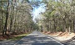
- 83003831 Ashley River Road.
Gallery
-
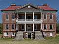
Drayton Hall, front view
-

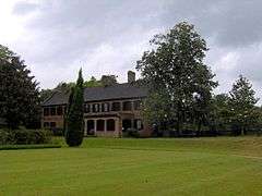
House at Magnolia Plantation
-
Middleton Place
-

Church Ruins in Old Dorchester
References
- 1 2 National Park Service (2010-07-09). "National Register Information System". National Register of Historic Places. National Park Service.
- ↑ Power, J. Tracy; Ian G. Hill; L.G. Tippett (July 26, 1994). "Ashley River Historic District" (pdf). National Register of Historic Places - Nomination and Inventory. Retrieved 9 June 2012.
- ↑ "Ashley River Historic District (Boundary Increase)" (pdf). National Register of Historic Places - Nomination and Inventory. July 26, 1994. Retrieved 9 June 2012.
- ↑ "Ashley River Historic District, Charleston and Dorchester County (along Ashley River & S.C. Hwy. 61, Charleston & Summerville vicinities, Charleston & Dorchester Counties)". National Register Properties in South Carolina. South Carolina Department of Archives and History. Retrieved 9 June 2012.
| Topics |   | |
|---|---|---|
| Lists by county |
| |
| Lists by city | ||
| Other lists | ||
This article is issued from Wikipedia - version of the 11/26/2016. The text is available under the Creative Commons Attribution/Share Alike but additional terms may apply for the media files.