National Register of Historic Places listings in McCormick County, South Carolina
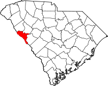
Location of McCormick County in South Carolina
This is a list of the National Register of Historic Places listings in McCormick County, South Carolina.
This is intended to be a complete list of the properties and districts on the National Register of Historic Places in McCormick County, South Carolina, United States. The locations of National Register properties and districts for which the latitude and longitude coordinates are included below, may be seen in a map.[1]
There are 20 properties and districts listed on the National Register in the county. Another property was once listed but has been removed.
- This National Park Service list is complete through NPS recent listings posted December 2, 2016.[2]
Current listings
| [3] |
Name on the Register[4] |
Image |
Date listed[5] |
Location |
City or town |
Description |
|---|
| 1 |
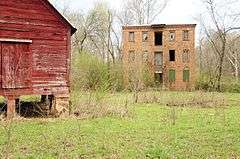
Calhoun Mill |
|
000000001980-11-24-0000November 24, 1980
(#80003679) |
Northeast of Mount Carmel
34°02′03″N 82°28′29″W / 34.034167°N 82.474722°W / 34.034167; -82.474722 (Calhoun Mill) |
Mount Carmel |
|
| 2 |
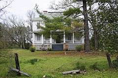
Calhoun-Gibert House |
|
000000001996-03-12-0000March 12, 1996
(#96000220) |
Secondary Road 33-60
33°58′20″N 82°28′25″W / 33.972222°N 82.473611°W / 33.972222; -82.473611 (Calhoun-Gibert House) |
Willington |
|
| 3 |
Dorn Gold Mine |
|
000000001985-12-12-0000December 12, 1985
(#85003341) |
Address Restricted
|
McCormick |
|
| 4 |
Dorn's Flour and Grist Mill |
|
000000001976-07-12-0000July 12, 1976
(#76002158) |
South Carolina Highway 28
33°54′48″N 82°17′48″W / 33.913333°N 82.296667°W / 33.913333; -82.296667 (Dorn's Flour and Grist Mill) |
McCormick |
|
| 5 |
Joseph Jennings Dorn House |
|
000000001985-12-12-0000December 12, 1985
(#85003342) |
Gold and Oak Sts.
33°54′50″N 82°17′37″W / 33.913889°N 82.293611°W / 33.913889; -82.293611 (Joseph Jennings Dorn House) |
McCormick |
|
| 6 |
Eden Hall |
|
000000001980-09-23-0000September 23, 1980
(#80003678) |
6 miles northeast of McCormick off U.S. Route 221 and South Carolina Highway 24
33°59′19″N 82°15′09″W / 33.988611°N 82.2525°W / 33.988611; -82.2525 (Eden Hall) |
McCormick |
|
| 7 |
Farmer's Bank |
|
000000001985-12-12-0000December 12, 1985
(#85003343) |
Main St.
33°54′45″N 82°17′37″W / 33.9125°N 82.293611°W / 33.9125; -82.293611 (Farmer's Bank) |
McCormick |
|
| 8 |
John Albert Gibert M.D. House |
|
000000001993-05-27-0000May 27, 1993
(#93000441) |
Secondary Road 7, 0.2 miles south of its junction with Secondary Road 110
33°55′33″N 82°25′09″W / 33.925833°N 82.419167°W / 33.925833; -82.419167 (John Albert Gibert M.D. House) |
McCormick |
|
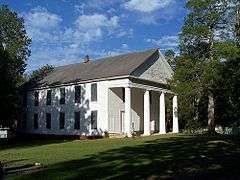
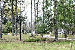
| 9 |
Guillebeau House |
|
000000001973-03-07-0000March 7, 1973
(#73002136) |
Hickory Knob State Park
33°56′47″N 82°26′36″W / 33.946389°N 82.443333°W / 33.946389; -82.443333 (Guillebeau House) |
Willington |
|
| 10 |
Otway Henderson House |
|
000000001985-12-12-0000December 12, 1985
(#85003344) |
Augusta St.
33°54′53″N 82°17′27″W / 33.914722°N 82.290833°W / 33.914722; -82.290833 (Otway Henderson House) |
McCormick |
|
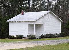
| 11 |
Hopewell Rosenwald School |
|
000000002010-06-09-0000June 9, 2010
(#10000340) |
Adjacent to 253 Hopewell Church Road (SC Sec RD 33-12)
33°36′25″N 82°07′12″W / 33.607078°N 82.120119°W / 33.607078; -82.120119 (Hopewell Rosenwald School) |
Clarks Hill |
|
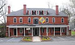
| 12 |
Hotel Keturah |
|
000000001985-12-12-0000December 12, 1985
(#85003345) |
Main St.
33°54′43″N 82°17′40″W / 33.911944°N 82.294444°W / 33.911944; -82.294444 (Hotel Keturah) |
McCormick |
|
| 13 |
Long Cane Massacre Site |
|
000000001983-01-27-0000January 27, 1983
(#83002203) |
West of Troy off South Carolina Highway 10
33°59′41″N 82°20′23″W / 33.994722°N 82.339722°W / 33.994722; -82.339722 (Long Cane Massacre Site) |
Troy |
|
| 14 |
Lower Long Cane Associate Reformed Presbyterian Church |
|
000000001999-10-06-0000October 6, 1999
(#98000426) |
Secondary Route 33-36, 4 miles west of Troy
34°00′58″N 82°20′57″W / 34.016111°N 82.349167°W / 34.016111; -82.349167 (Lower Long Cane Associate Reformed Presbyterian Church) |
Troy |
|
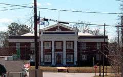
| 15 |
McCormick County Courthouse |
|
000000001985-12-12-0000December 12, 1985
(#85003346) |
South Carolina Highway 28
33°54′38″N 82°17′42″W / 33.910556°N 82.295°W / 33.910556; -82.295 (McCormick County Courthouse) |
McCormick |
|
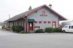
| 16 |
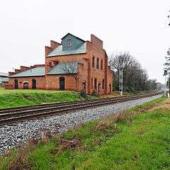
McCormick Train Station |
|
000000001985-12-12-0000December 12, 1985
(#85003347) |
Main St.
33°54′42″N 82°17′36″W / 33.911667°N 82.293333°W / 33.911667; -82.293333 (McCormick Train Station) |
McCormick |
|
| 17 |
Mount Carmel Historic District |
|
000000001982-06-22-0000June 22, 1982
(#82003895) |
South Carolina Highways 81 and 823
34°00′30″N 82°30′28″W / 34.008333°N 82.507778°W / 34.008333; -82.507778 (Mount Carmel Historic District) |
Mount Carmel |
|
| 18 |
Price's Mill |
|
000000001972-11-22-0000November 22, 1972
(#72001465) |
East of Parksville on South Carolina Highway 138 at Steven's Creek
33°47′39″N 82°11′43″W / 33.794167°N 82.195278°W / 33.794167; -82.195278 (Price's Mill) |
Parksville |
|
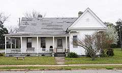
| 19 |
M.L.B. Sturkey House |
|
000000001985-12-12-0000December 12, 1985
(#85003348) |
Main and Washington Sts.
33°54′38″N 82°17′28″W / 33.910556°N 82.291111°W / 33.910556; -82.291111 (M.L.B. Sturkey House) |
McCormick |
|
| 20 |
Sylvania |
|
000000001977-11-28-0000November 28, 1977
(#77001533) |
South of Bradley off South Carolina Highway 10
34°00′35″N 82°14′24″W / 34.009722°N 82.24°W / 34.009722; -82.24 (Sylvania) |
Bradley |
|
See also
References
- ↑ The latitude and longitude information provided in this table was derived originally from the National Register Information System, which has been found to be fairly accurate for about 99% of listings. For about 1% of NRIS original coordinates, experience has shown that one or both coordinates are typos or otherwise extremely far off; some corrections may have been made. A more subtle problem causes many locations to be off by up to 150 yards, depending on location in the country: most NRIS coordinates were derived from tracing out latitude and longitudes off of USGS topographical quadrant maps created under the North American Datum of 1927, which differs from the current, highly accurate WGS84 GPS system used by most on-line maps. Chicago is about right, but NRIS longitudes in Washington are higher by about 4.5 seconds, and are lower by about 2.0 seconds in Maine. Latitudes differ by about 1.0 second in Florida. Some locations in this table may have been corrected to current GPS standards.
- ↑ "National Register of Historic Places: Weekly List Actions". National Park Service, United States Department of the Interior. Retrieved on December 2, 2016.
- 1 2 Numbers represent an ordering by significant words. Various colorings, defined here, differentiate National Historic Landmarks and historic districts from other NRHP buildings, structures, sites or objects.
- ↑ National Park Service (2009-03-13). "National Register Information System". National Register of Historic Places. National Park Service.
- ↑ The eight-digit number below each date is the number assigned to each location in the National Register Information System database, which can be viewed by clicking the number.
- ↑
|
|---|
|
| Topics | | |
|---|
|
Lists
by county | |
|---|
|
| Lists by city | |
|---|
|
| Other lists | |
|---|
|
|