| [3] |
Name on the Register[4] |
Image |
Date listed[5] |
Location |
City or town |
Description |
|---|
| 1 |
All Saints' Episcopal Church, Waccamaw |
|
000000001991-03-13-0000March 13, 1991
(#91000232) |
South Carolina Highway 255 0.2 miles north of its junction with South Carolina Highway 46
33°28′03″N 79°08′24″W / 33.4675°N 79.14°W / 33.4675; -79.14 (All Saints' Episcopal Church, Waccamaw) |
Pawleys Island |
|
| 2 |
Annandale Plantation |
Upload image |
000000001973-10-25-0000October 25, 1973
(#73001709) |
About 14 miles south of Georgetown between South Carolina Highways 18 and 30
33°13′01″N 79°18′10″W / 33.216944°N 79.302778°W / 33.216944; -79.302778 (Annandale Plantation) |
Georgetown |
|
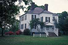
| 3 |
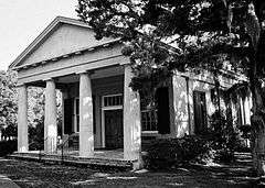
Arcadia Plantation |
|
000000001978-01-03-0000January 3, 1978
(#78002509) |
5 miles (8 km) east of Georgetown off U.S. Route 17
33°23′01″N 79°13′25″W / 33.383611°N 79.223611°W / 33.383611; -79.223611 (Arcadia Plantation) |
Georgetown |
|
| 4 |
Atalaya |
|
000000001984-09-07-0000September 7, 1984
(#84002045) |
Off U.S. Route 17
33°30′50″N 79°05′07″W / 33.513889°N 79.085278°W / 33.513889; -79.085278 (Atalaya) |
Murrells Inlet |
|
| 5 |
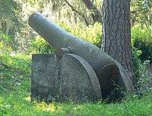
Battery White |
|
000000001977-11-16-0000November 16, 1977
(#77001222) |
South of Georgetown on Belle Isle Rd.
33°18′13″N 79°17′46″W / 33.303611°N 79.296111°W / 33.303611; -79.296111 (Battery White) |
Georgetown |
|
| 6 |
Belle Isle Rice Mill Chimney |
Upload image |
000000001988-10-03-0000October 3, 1988
(#88000525) |
Cat Island
33°12′02″N 79°15′30″W / 33.200556°N 79.258333°W / 33.200556; -79.258333 (Belle Isle Rice Mill Chimney) |
Georgetown |
|
| 7 |
Beneventum Plantation House |
|
000000001988-10-03-0000October 3, 1988
(#88000526) |
Off County Road 431
33°26′43″N 79°15′39″W / 33.445278°N 79.260833°W / 33.445278; -79.260833 (Beneventum Plantation House) |
Georgetown |
|
| 8 |
Black River Plantation House |
Upload image |
000000001994-03-02-0000March 2, 1994
(#94000062) |
Southwestern side of South Carolina Highway 51, 0.5 miles northwest of Peters Creek
33°30′37″N 79°18′01″W / 33.510278°N 79.300278°W / 33.510278; -79.300278 (Black River Plantation House) |
Georgetown |
|
| 9 |
Brookgreen Gardens |
|
000000001978-04-15-0000April 15, 1978
(#78002510) |
18 miles (28.8 km) northeast of Georgetown on U.S. Route 17
33°31′14″N 79°05′59″W / 33.520556°N 79.099722°W / 33.520556; -79.099722 (Brookgreen Gardens) |
Georgetown |
|
| 10 |
Cedar Grove Plantation Chapel |
Upload image |
000000001991-03-13-0000March 13, 1991
(#91000231) |
South Carolina Highway 255, 0.2 miles north of its junction with South Carolina Highway 46
33°28′02″N 79°08′19″W / 33.467222°N 79.138611°W / 33.467222; -79.138611 (Cedar Grove Plantation Chapel) |
Pawleys Island |
|
| 11 |
Chicora Wood Plantation |
|
000000001973-04-11-0000April 11, 1973
(#73001710) |
12 miles northeast of Georgetown on County Road 52
33°31′03″N 79°10′32″W / 33.5175°N 79.175556°W / 33.5175; -79.175556 (Chicora Wood Plantation) |
Georgetown |
|
| 12 |
Fairfield Rice Mill Chimney |
Upload image |
000000001988-10-03-0000October 3, 1988
(#88000527) |
Off U.S. Route 17
33°23′33″N 79°13′11″W / 33.3925°N 79.219722°W / 33.3925; -79.219722 (Fairfield Rice Mill Chimney) |
Georgetown |
|
| 13 |
Friendfield Plantation |
|
000000001996-04-12-0000April 12, 1996
(#96000409) |
Roughly bounded by U.S. Route 521-17A, the Sampit River, Whites Creek, and Creek Rd.
33°22′39″N 79°20′29″W / 33.3775°N 79.341389°W / 33.3775; -79.341389 (Friendfield Plantation) |
Georgetown |
|
| 14 |
Georgetown Historic District |
|
000000001971-10-14-0000October 14, 1971
(#71000781) |
Along the northern side of the Sampit River
33°21′58″N 79°16′51″W / 33.366111°N 79.280833°W / 33.366111; -79.280833 (Georgetown Historic District) |
Georgetown |
|
| 15 |
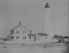
Georgetown Lighthouse |
|
000000001974-12-30-0000December 30, 1974
(#74001857) |
On North Island, about 12 miles southeast of Georgetown
33°13′20″N 79°11′07″W / 33.222222°N 79.185278°W / 33.222222; -79.185278 (Georgetown Lighthouse) |
Georgetown |
|
| 16 |
Hobcaw Barony |
|
000000001994-11-02-0000November 2, 1994
(#94001236) |
Roughly bounded by U.S. Route 17, Winyah and Mud Bays and Jones Creek
33°19′23″N 79°13′06″W / 33.323056°N 79.218333°W / 33.323056; -79.218333 (Hobcaw Barony) |
Georgetown |
|
| 17 |
Hopsewee |
|
000000001971-01-25-0000January 25, 1971
(#71000782) |
12 miles south of Georgetown on U.S. Route 17
33°12′38″N 79°23′05″W / 33.210556°N 79.384722°W / 33.210556; -79.384722 (Hopsewee) |
Georgetown |
|
| 18 |
Keithfield Plantation |
Upload image |
000000001988-10-03-0000October 3, 1988
(#88000529) |
Off County Road 52
33°26′21″N 79°14′31″W / 33.439167°N 79.241944°W / 33.439167; -79.241944 (Keithfield Plantation) |
Georgetown |
|
| 19 |
Mansfield Plantation |
|
000000001977-12-06-0000December 6, 1977
(#77001223) |
5 miles north of Georgetown off U.S. Route 701
33°26′05″N 79°15′33″W / 33.434722°N 79.259167°W / 33.434722; -79.259167 (Mansfield Plantation) |
Georgetown |
|
| 20 |
Milldam Rice Mill and Rice Barn |
Upload image |
000000001988-10-03-0000October 3, 1988
(#88000530) |
Off County Road 30
33°12′09″N 79°19′58″W / 33.2025°N 79.332778°W / 33.2025; -79.332778 (Milldam Rice Mill and Rice Barn) |
Georgetown |
|
| 21 |
Minim Island Shell Midden (38GE46) |
|
000000001982-08-18-0000August 18, 1982
(#82003852) |
Address Restricted
|
Georgetown |
|
| 22 |
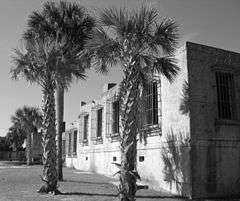
Murrells Inlet Historic District |
Upload image |
000000001980-11-25-0000November 25, 1980
(#80003670) |
Off U.S. Route 17
33°33′44″N 79°01′14″W / 33.562222°N 79.020556°W / 33.562222; -79.020556 (Murrells Inlet Historic District) |
Murrells Inlet |
|
| 23 |
Nightingale Hall Rice Mill Chimney |
Upload image |
000000001988-10-03-0000October 3, 1988
(#88000531) |
Off County Road 52
33°26′46″N 79°12′46″W / 33.446111°N 79.212778°W / 33.446111; -79.212778 (Nightingale Hall Rice Mill Chimney) |
Georgetown |
|
| 24 |
Old Market Building |
|
000000001969-12-03-0000December 3, 1969
(#69000166) |
Front and Screven Sts.
33°21′56″N 79°16′57″W / 33.365556°N 79.2825°W / 33.365556; -79.2825 (Old Market Building) |
Georgetown |
|
| 25 |
Pawleys Island Historic District |
Upload image |
000000001972-11-15-0000November 15, 1972
(#72001211) |
Western side of Pawleys Island
33°25′26″N 79°07′50″W / 33.423889°N 79.130556°W / 33.423889; -79.130556 (Pawleys Island Historic District) |
Pawleys Island |
|
| 26 |
Pee Dee River Rice Planters Historic District |
|
000000001988-10-03-0000October 3, 1988
(#88000532) |
Along the Pee Dee and Waccamaw Rivers
33°30′13″N 79°10′11″W / 33.503611°N 79.169722°W / 33.503611; -79.169722 (Pee Dee River Rice Planters Historic District) |
Georgetown |
|
| 27 |
Pleasant Hill Consolidated School |
Upload image |
000000001998-04-30-0000April 30, 1998
(#98000421) |
11957 Pleasant Hill Dr.
33°40′44″N 79°22′07″W / 33.678889°N 79.368611°W / 33.678889; -79.368611 (Pleasant Hill Consolidated School) |
Hemingway |
|
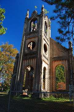
| 28 |
Prince Frederick's Chapel Ruins |
|
000000001974-08-28-0000August 28, 1974
(#74001858) |
Southeast of Plantersville on County Road 52
33°30′20″N 79°10′49″W / 33.505556°N 79.180278°W / 33.505556; -79.180278 (Prince Frederick's Chapel Ruins) |
Plantersville |
|
| 29 |
Prince George Winyah Church (Episcopal) and Cemetery |
|
000000001971-05-06-0000May 6, 1971
(#71000783) |
Corner of Broad and Highmarket Sts.
33°22′08″N 79°16′49″W / 33.368889°N 79.280278°W / 33.368889; -79.280278 (Prince George Winyah Church (Episcopal) and Cemetery) |
Georgetown |
|
| 30 |
Joseph H. Rainey House |
|
000000001984-04-20-0000April 20, 1984
(#84003877) |
909 Prince St.
33°22′08″N 79°17′05″W / 33.368889°N 79.284722°W / 33.368889; -79.284722 (Joseph H. Rainey House) |
Georgetown |
|
| 31 |
Richmond Hill Plantation Archeological Sites |
|
000000001988-10-06-0000October 6, 1988
(#88000537) |
Address Restricted
|
Murrells Inlet |
|
| 32 |
Rural Hall Plantation House |
Upload image |
000000001988-10-03-0000October 3, 1988
(#88000533) |
Off County Road 179
33°30′46″N 79°20′40″W / 33.512778°N 79.344444°W / 33.512778; -79.344444 (Rural Hall Plantation House) |
Georgetown |
|
| 33 |
Summer Chapel Rectory, Prince Frederick's Episcopal Church |
Upload image |
000000001988-10-03-0000October 3, 1988
(#88000536) |
County Road 52
33°33′18″N 79°12′53″W / 33.555°N 79.214722°W / 33.555; -79.214722 (Summer Chapel Rectory, Prince Frederick's Episcopal Church) |
Plantersville |
|
| 34 |
Summer Chapel, Prince Frederick's Episcopal Church |
Upload image |
000000001988-10-03-0000October 3, 1988
(#88000535) |
County Road 52
33°33′17″N 79°12′42″W / 33.554722°N 79.211667°W / 33.554722; -79.211667 (Summer Chapel, Prince Frederick's Episcopal Church) |
Plantersville |
|
| 35 |
Weehaw Rice Mill Chimney |
Upload image |
000000001988-10-03-0000October 3, 1988
(#88000534) |
Off County Road 325
33°24′18″N 79°16′04″W / 33.405°N 79.267778°W / 33.405; -79.267778 (Weehaw Rice Mill Chimney) |
Georgetown |
|
| 36 |
Wicklow Hall Plantation |
|
000000001978-08-29-0000August 29, 1978
(#78002511) |
South of Georgetown on South Carolina Highway 30
33°12′50″N 79°18′56″W / 33.213889°N 79.315556°W / 33.213889; -79.315556 (Wicklow Hall Plantation) |
Georgetown |
|
| 37 |
Winyah Indigo School |
|
000000001988-11-03-0000November 3, 1988
(#88002386) |
1200 Highmarket St.
33°22′22″N 79°17′11″W / 33.372778°N 79.286389°W / 33.372778; -79.286389 (Winyah Indigo School) |
Georgetown |
|

_ELEVATION_-_Arcadia_Plantation%2C_U.S._Highway_17_vicinity%2C_Georgetown%2C_Georgetown_County%2C_SC_HABS_SC%2C22-GEOTO.V%2C5-2.tif.jpg)
.jpg)

%2C_Georgetown_vicinity_(Georgetown_County%2C_South_Carolina).jpg)
.jpg)
.jpg)
_5a31131r.jpg)

.jpg)
.jpg)

.jpg)


