Atarib District
| Atarib District منطقة الأتارب | |
|---|---|
| District | |
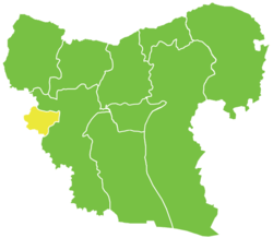 Location of Atarib District within Aleppo Governorate | |
| Coordinates (Aleppo): 36°08′N 36°49′E / 36.13°N 36.82°ECoordinates: 36°08′N 36°49′E / 36.13°N 36.82°E | |
| Country |
|
| Governorate | Aleppo |
| Seat | Aleppo |
| Subdistricts | 3 nawāḥī |
| Area | |
| • Total | 308.22 km2 (119.00 sq mi) |
| Population (2004)[1] | 76,873 |
| Geocode | SY0210 |
Atarib District (Arabic: منطقة الأتارب, translit. manṭiqat al-Atārib) is a district of Aleppo Governorate in northern Syria. Administrative centre is the city of Atarib.
The district is located in the central western region of the Aleppo Governorate, sharing its west border with the Idlib Governorate. Until December 2008, it was a sub-district of the neighboring Mount Simeon District.[2] At the 2004 census, the sub-district had a population of 76,873.[1]
Sub-districts
The district of Atarib is divided into three sub-districts or nawāḥī:
| Code | Name | Area | Population | Seat |
|---|---|---|---|---|
| SY021000 | Nahiya Atarib | km² | 32,186 | Atarib |
| SY021001 | Nahiya Ibbin Samaan | km² | 21,925 | Ibbin Samaan |
| SY021002 | Nahiya Urum al-Kubrah | km² | 22,851 | Urum al-Kubrah |
References
- 1 2 "General Census of Population and Housing 2004" (PDF) (in Arabic). Syrian Central Bureau of Statistics. Archived from the original (PDF) on 8 December 2015. Retrieved 15 October 2015. Also available in English: "2004 Census Data". UN OCHA. Retrieved 15 October 2015.
- ↑ "إحداث منطقتي دير حافر والأتارب سيساهم في النهضة التنموية بالمحافظة". Al-Jamahir (in Arabic). Aleppo. 25 February 2009. Retrieved 24 January 2016.
Capital: Aleppo | ||||||||
|  | |||||||
|
| ||||||||
| ||||||||
| ||||||||
| ||||||||
| ||||||||
This article is issued from Wikipedia - version of the 10/20/2016. The text is available under the Creative Commons Attribution/Share Alike but additional terms may apply for the media files.