Axtell, Kansas
| Axtell, Kansas | |
|---|---|
| City | |
 Location within Marshall County and Kansas | |
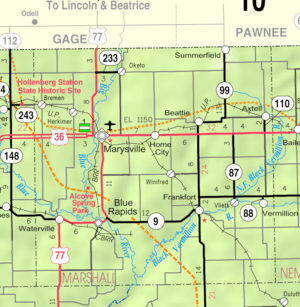 KDOT map of Marshall County (legend) | |
| Coordinates: 39°52′21″N 96°15′26″W / 39.87250°N 96.25722°WCoordinates: 39°52′21″N 96°15′26″W / 39.87250°N 96.25722°W | |
| Country | United States |
| State | Kansas |
| County | Marshall |
| Area[1] | |
| • Total | 0.51 sq mi (1.32 km2) |
| • Land | 0.51 sq mi (1.32 km2) |
| • Water | 0 sq mi (0 km2) |
| Elevation | 1,362 ft (415 m) |
| Population (2010)[2] | |
| • Total | 406 |
| • Estimate (2012[3]) | 401 |
| • Density | 800/sq mi (310/km2) |
| Time zone | Central (CST) (UTC-6) |
| • Summer (DST) | CDT (UTC-5) |
| ZIP code | 66403 |
| Area code | 785 |
| FIPS code | 20-03600 [4] |
| GNIS feature ID | 0472717 [5] |
| Website | City Website |
Axtell is a city in Marshall County, Kansas, United States. As of the 2010 census, the city population was 406.[6]
History
The first settlements were made at Axtell in the 1860s.[7] The first post office in Axtell was established in December 1871.[8] Axtell was laid out in 1872 when the railroad was extended to that point, and a railroad depot was built that year.[9] It was named for Dr. Jesse Axtell, a railroad official.[10]
Geography
Axtell is located at 39°52′21″N 96°15′26″W / 39.87250°N 96.25722°W (39.872447, -96.257361).[11] According to the United States Census Bureau, the city has a total area of 0.51 square miles (1.32 km2), all of it land.[1]
Climate
This climatic region is typified by large seasonal temperature differences, with warm to hot (and often humid) summers and cold (sometimes severely cold) winters. According to the Köppen Climate Classification system, Axtell has a humid continental climate, abbreviated "Dfa" on climate maps.[12]
Demographics
| Historical population | |||
|---|---|---|---|
| Census | Pop. | %± | |
| 1880 | 255 | — | |
| 1890 | 643 | 152.2% | |
| 1900 | 651 | 1.2% | |
| 1910 | 748 | 14.9% | |
| 1920 | 617 | −17.5% | |
| 1930 | 607 | −1.6% | |
| 1940 | 545 | −10.2% | |
| 1950 | 510 | −6.4% | |
| 1960 | 493 | −3.3% | |
| 1970 | 456 | −7.5% | |
| 1980 | 470 | 3.1% | |
| 1990 | 432 | −8.1% | |
| 2000 | 445 | 3.0% | |
| 2010 | 406 | −8.8% | |
| Est. 2015 | 403 | [13] | −0.7% |
| U.S. Decennial Census | |||
2010 census
As of the census[2] of 2010, there were 406 people, 178 households, and 111 families residing in the city. The population density was 796.1 inhabitants per square mile (307.4/km2). There were 194 housing units at an average density of 380.4 per square mile (146.9/km2). The racial makeup of the city was 96.8% White and 3.2% from two or more races.
There were 178 households of which 24.7% had children under the age of 18 living with them, 52.8% were married couples living together, 5.6% had a female householder with no husband present, 3.9% had a male householder with no wife present, and 37.6% were non-families. 33.1% of all households were made up of individuals and 16.3% had someone living alone who was 65 years of age or older. The average household size was 2.28 and the average family size was 2.95.
The median age in the city was 43 years. 25.1% of residents were under the age of 18; 6.9% were between the ages of 18 and 24; 19.7% were from 25 to 44; 25.1% were from 45 to 64; and 23.2% were 65 years of age or older. The gender makeup of the city was 51.7% male and 48.3% female.
2000 census
As of the census[4] of 2000, there were 445 people, 182 households, and 129 families residing in the city. The population density was 882.6 people per square mile (343.6/km²). There were 204 housing units at an average density of 404.6 per square mile (157.5/km²). The racial makeup of the city was 96.85% White, 0.90% Native American, 0.22% Asian, 1.12% from other races, and 0.90% from two or more races. Hispanic or Latino of any race were 1.57% of the population.
There were 182 households out of which 30.2% had children under the age of 18 living with them, 59.9% were married couples living together, 8.8% had a female householder with no husband present, and 28.6% were non-families. 27.5% of all households were made up of individuals and 10.4% had someone living alone who was 65 years of age or older. The average household size was 2.45 and the average family size was 2.99.
In the city the population was spread out with 26.7% under the age of 18, 6.7% from 18 to 24, 23.1% from 25 to 44, 23.1% from 45 to 64, and 20.2% who were 65 years of age or older. The median age was 40 years. For every 100 females there were 91.0 males. For every 100 females age 18 and over, there were 89.5 males.
The median income for a household in the city was $30,192, and the median income for a family was $35,000. Males had a median income of $29,250 versus $23,500 for females. The per capita income for the city was $14,460. About 12.3% of families and 11.1% of the population were below the poverty line, including 15.7% of those under age 18 and 8.7% of those age 65 or over.
References
- 1 2 "US Gazetteer files 2010". United States Census Bureau. Archived from the original on 2012-01-24. Retrieved 2012-07-06.
- 1 2 "American FactFinder". United States Census Bureau. Retrieved 2012-07-06.
- ↑ "Population Estimates". United States Census Bureau. Archived from the original on 2013-06-17. Retrieved 2013-05-29.
- 1 2 "American FactFinder". United States Census Bureau. Archived from the original on 2013-09-11. Retrieved 2008-01-31.
- ↑ "US Board on Geographic Names". United States Geological Survey. 2007-10-25. Retrieved 2008-01-31.
- ↑ "2010 City Population and Housing Occupancy Status". U.S. Census Bureau. Archived from the original on 21 July 2011. Retrieved July 17, 2011.
- ↑ Blackmar, Frank Wilson (1912). Kansas: A Cyclopedia of State History, Embracing Events, Institutions, Industries, Counties, Cities, Towns, Prominent Persons, Etc. Standard Publishing Company. p. 120.
- ↑ "Kansas Post Offices, 1828-1961 (archived)". Kansas Historical Society. Archived from the original on October 9, 2013. Retrieved 14 June 2014.
- ↑ Foster, Emma Elizabeth Calderhead (1917). History of Marshall County, Kansas: Its People, Industries, and Institutions. B.F. Bowen. p. 155.
- ↑ Kansas State Historical Society (1916). Biennial Report of the Board of Directors of the Kansas State Historical Society. Kansas State Printing Plant. p. 236.
- ↑ "US Gazetteer files: 2010, 2000, and 1990". United States Census Bureau. 2011-02-12. Retrieved 2011-04-23.
- ↑ Climate Summary for Axtell, Kansas
- ↑ "Annual Estimates of the Resident Population for Incorporated Places: April 1, 2010 to July 1, 2015". Retrieved July 2, 2016.
External links
| Wikimedia Commons has media related to Axtell, Kansas. |
- City
- Schools
- USD 113, local school district
- Maps
- Axtell City Map, KDOT
Municipalities and communities of Marshall County, Kansas, United States | ||
|---|---|---|
| Cities | 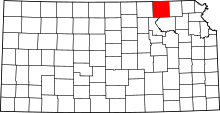 | |
| CDP | ||
| Unincorporated communities | ||
| Ghost towns | ||
| Townships | ||