Oketo, Kansas
| Oketo, Kansas | |
|---|---|
| City | |
 Location within Marshall County and Kansas | |
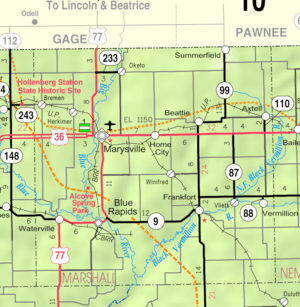 KDOT map of Marshall County (legend) | |
| Coordinates: 39°57′46″N 96°35′56″W / 39.96278°N 96.59889°WCoordinates: 39°57′46″N 96°35′56″W / 39.96278°N 96.59889°W | |
| Country | United States |
| State | Kansas |
| County | Marshall |
| Area[1] | |
| • Total | 0.11 sq mi (0.28 km2) |
| • Land | 0.11 sq mi (0.28 km2) |
| • Water | 0 sq mi (0 km2) |
| Elevation | 1,263 ft (385 m) |
| Population (2010)[2] | |
| • Total | 66 |
| • Estimate (2012[3]) | 65 |
| • Density | 600/sq mi (240/km2) |
| Time zone | Central (CST) (UTC-6) |
| • Summer (DST) | CDT (UTC-5) |
| ZIP code | 66518 |
| Area code | 785 |
| FIPS code | 20-52525 [4] |
| GNIS feature ID | 0472693 [5] |
Oketo is a city in Marshall County, Kansas, United States. As of the 2010 census, the city population was 66.[6]
History
Oketo was incorporated as a city in 1870.[7] It was named for a chief of the Otoe tribe.[8]
The first post office in Oketo was established in May 1873.[9]
Geography
Oketo is located at 39°57′46″N 96°35′56″W / 39.96278°N 96.59889°W (39.962882, -96.598896).[10] According to the United States Census Bureau, the city has a total area of 0.11 square miles (0.28 km2), all of it land.[1]
Demographics
| Historical population | |||
|---|---|---|---|
| Census | Pop. | %± | |
| 1890 | 334 | — | |
| 1900 | 347 | 3.9% | |
| 1910 | 253 | −27.1% | |
| 1920 | 225 | −11.1% | |
| 1930 | 225 | 0.0% | |
| 1940 | 218 | −3.1% | |
| 1950 | 169 | −22.5% | |
| 1960 | 128 | −24.3% | |
| 1970 | 133 | 3.9% | |
| 1980 | 130 | −2.3% | |
| 1990 | 116 | −10.8% | |
| 2000 | 87 | −25.0% | |
| 2010 | 66 | −24.1% | |
| Est. 2015 | 64 | [11] | −3.0% |
| U.S. Decennial Census | |||
2010 census
As of the census[2] of 2010, there were 66 people, 31 households, and 19 families residing in the city. The population density was 600.0 inhabitants per square mile (231.7/km2). There were 38 housing units at an average density of 345.5 per square mile (133.4/km2). The racial makeup of the city was 100.0% White. Hispanic or Latino of any race were 1.5% of the population.
There were 31 households of which 29.0% had children under the age of 18 living with them, 48.4% were married couples living together, 3.2% had a female householder with no husband present, 9.7% had a male householder with no wife present, and 38.7% were non-families. 38.7% of all households were made up of individuals and 19.4% had someone living alone who was 65 years of age or older. The average household size was 2.13 and the average family size was 2.68.
The median age in the city was 46.5 years. 22.7% of residents were under the age of 18; 4.5% were between the ages of 18 and 24; 15.1% were from 25 to 44; 34.8% were from 45 to 64; and 22.7% were 65 years of age or older. The gender makeup of the city was 51.5% male and 48.5% female.
2000 census
As of the census[4] of 2000, there were 87 people, 41 households, and 28 families residing in the city. The population density was 811.2 people per square mile (305.4/km²). There were 47 housing units at an average density of 438.2 per square mile (165.0/km²). The racial makeup of the city was 95.40% White, and 4.60% from two or more races.
There were 41 households out of which 24.4% had children under the age of 18 living with them, 61.0% were married couples living together, 7.3% had a female householder with no husband present, and 31.7% were non-families. 29.3% of all households were made up of individuals and 12.2% had someone living alone who was 65 years of age or older. The average household size was 2.12 and the average family size was 2.57.
In the city the population was spread out with 20.7% under the age of 18, 2.3% from 18 to 24, 29.9% from 25 to 44, 23.0% from 45 to 64, and 24.1% who were 65 years of age or older. The median age was 44 years. For every 100 females there were 112.2 males. For every 100 females age 18 and over, there were 97.1 males.
The median income for a household in the city was $26,667, and the median income for a family was $30,893. Males had a median income of $26,042 versus $20,833 for females. The per capita income for the city was $16,862. There were 8.7% of families and 9.5% of the population living below the poverty line, including no under eighteens and none of those over 64.
Notable people
- Thomas Olmsted, Roman Catholic bishop
References
- 1 2 "US Gazetteer files 2010". United States Census Bureau. Archived from the original on January 24, 2012. Retrieved 2012-07-06.
- 1 2 "American FactFinder". United States Census Bureau. Retrieved 2012-07-06.
- ↑ "Population Estimates". United States Census Bureau. Archived from the original on June 17, 2013. Retrieved 2013-05-29.
- 1 2 "American FactFinder". United States Census Bureau. Archived from the original on September 11, 2013. Retrieved 2008-01-31.
- ↑ "US Board on Geographic Names". United States Geological Survey. 2007-10-25. Retrieved 2008-01-31.
- ↑ "2010 City Population and Housing Occupancy Status". U.S. Census Bureau. Archived from the original on July 21, 2011. Retrieved July 17, 2011.
- ↑ Blackmar, Frank Wilson (1912). Kansas: A Cyclopedia of State History, Volume 2. Standard Publishing Company. p. 386.
- ↑ Kansas State Historical Society (1916). Biennial Report of the Board of Directors of the Kansas State Historical Society. Kansas State Printing Plant. p. 237.
- ↑ "Kansas Post Offices, 1828-1961 (archived)". Kansas Historical Society. Archived from the original on October 9, 2013. Retrieved 14 June 2014.
- ↑ "US Gazetteer files: 2010, 2000, and 1990". United States Census Bureau. 2011-02-12. Retrieved 2011-04-23.
- ↑ "Annual Estimates of the Resident Population for Incorporated Places: April 1, 2010 to July 1, 2015". Retrieved July 2, 2016.
External links
| Wikimedia Commons has media related to Oketo, Kansas. |
- City
- Schools
- USD 364, local school district
- Maps
- Oketo City Map, KDOT
Municipalities and communities of Marshall County, Kansas, United States | ||
|---|---|---|
| Cities | 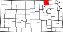 | |
| CDP | ||
| Unincorporated communities | ||
| Ghost towns | ||
| Townships | ||