Ballyconnell
| Ballyconnell Béal Átha Conaill | |
|---|---|
| Town | |
|
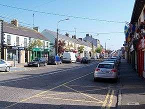
Ballyconnell Main Street. | |
 Ballyconnell Location in Ireland | |
| Coordinates: 54°07′00″N 7°35′00″W / 54.11667°N 7.58333°WCoordinates: 54°07′00″N 7°35′00″W / 54.11667°N 7.58333°W | |
| Country | Ireland |
| Province | Ulster |
| County | County Cavan |
| Elevation | 55 m (180 ft) |
| Population (2011) | |
| • Urban | 1,061 |
| Time zone | WET (UTC+0) |
| • Summer (DST) | IST (WEST) (UTC-1) |
| Irish Grid Reference | H361168 |

Ballyconnell (Irish: Béal Átha Conaill, meaning "Entrance to the Ford of Conall") is a town in County Cavan, Ireland. It is situated on the N87 national secondary road at the junction of four townlands Annagh, Cullyleenan, Doon and Derryginny in the parish of Tomregan, Barony of Tullyhaw. The town has an altitude of 55 metres above sea level. The mean daily January temperature is 4.5 degrees Celsius and the mean daily July temperature is 15 degrees Celsius. The average annual rainfall is 1,000 mm. The average annual hours of sunshine are 1,250. Ballyconnell won the Irish Tidy Towns Competition in 1971 and was also winner in 1975.[1]
It lies astride the Shannon–Erne Waterway which was opened in 1993, formerly known as the Woodford Canal which was finally completed in 1860. Prior to being canalised it was known as the River Grainne. The town sits at the foot of Slieve Rushen mountain and is a mile from the border between Northern Ireland and the Republic of Ireland. The population of Ballyconnell according to the most recent census undertaken in 2006 was 747 persons, an increase of 31% on the previous 2002 census.
Name
The earliest surviving mention of the name Ballyconnell is an entry in the Annals of the Four Masters for the year 1323 A.D., which states "Rory Mac Mahon, son of the Lord of Oriel, Melaghlin O'Seagannain, and Mac Muldoon, were slain by Cathal O'Rourke at Bel-atha-Chonaill". Before being named Ballyconnell it was named Áth na Mianna which means Ford of the Miners. It was also named Gwyllymsbrook between 1660 and 1702 by its then owner Thomas Gwyllym.[2]
The name is an anglicization of Bél Átha Conaill which means "The entrance to Conall's Ford". The ford was a shallow crossing over the River Grainne and was the ancient border crossing for travellers going between Ulster and Connacht. The ford was caused by silt and gravel washed down from the nearby Slieve Rushen mountain by the Tanyard Stream which flows into the Grainne about 20 yards upriver from Ballyconnell bridge on the western outskirts of the town.
Conall was the great Ulster Hero and Red Branch knight Conall Cernach, who was killed at Ballyconnell by the three Ruadhcoin sent by Queen Maeve of Connacht to avenge the slaying of her husband Ailill by Conall.[3]
History
Prehistoric
The area was settled at an early date, as evidenced by the double-court tomb in the town dating from c. 3,500 B.C. and a ring barrow in the same field (Sites number 31 & 107, Doon townland, "Archaeological Inventory of County Cavan", Patrick O’Donovan, 1995, pp. 7 & 22).
The ford would have been a logical place to erect a settlement and it probably dates from the time of the court tomb. The earliest inhabitants were hunter-gatherers rather than farmers. They lived by fishing, hunting wild game and foraging for berries and nuts. This area would have been thickly wooded at the time, with no roadways. The easiest way to travel would have been by boat via the river and the numerous lakes and streams in the area. The only other known megalith in the parish is a wedge tomb dating from 2000 B.C. on the side of Slieve Rushen mountain in Aughrim townland (Site number 7, Aughrim townland, "Archaeological Inventory of County Cavan", Patrick O’Donovan, 1995, p. 2). However, after remaining undisturbed for 4,000 years it was recently dug up by the Quinn Group to enable them to mine sand deposits from the mountain. It was relocated to the grounds of the group's hotel, The Slieve Russell, to serve as a tourist attraction.
Medieval
In ancient times, Ballyconnell lay on the eastern part of Magh Slécht named Maigin ("the little plain"), so called because it was a narrow strip bounded on the north by Slieve Rushen mountain and on the south by the River Graine. Maigin was the birthplace of Saint Dallán Forgaill.
In medieval times the town belonged to the McGovern chiefs who had a fort there. Ballyconnell was situated in one of the ballybetoes of Tullyhaw named Calmhagh (Calva), which basically means almost the same as Maigin, the narrow plain. As it was on the border between Fermanagh and Breifne, Ballyconnell was a flash-point for the wars between the Maguires, O'Rourkes, O'Reillys, McGoverns, McKiernans and their allies. The Annals of Ireland record incidents at Ballyconnell in the following years- 1323 Rory MacMahon, Mel O'Seagannain & MacMuldoon were slain at Ballyconnell by Cathal O'Rourke.[4] 1457 Brian Maguire fought with Lochlann O'Rourke, the McGoverns & McKiernans at Ballyconnell.[5] 1470 O'Donnell & O'Rourke fought with O'Reilly, the English and the McKiernans at Ballyconnell.[6] 1475 Hugh Roe O'Donnell went to Ballyconnell to make peace with the O'Reilly.[7] 1595 O'Donnell camped at Ballyconnell after raiding the town of Cavan.[8]
Post-1600
In 1605 Captain Richard Tyrrell bought the Calva estate from Cormac Magauran. He sold the estate to Walter Talbot, a recusant servitor who was the son of James Talbot of Agherskeethe (now Augherskea), County Meath and a burgess of Cavan Corporation, before 1609 but the title was defective. However, in the Plantation of Ulster in 1609 Sir Arthur Chichester, the Lord Deputy of Ireland, allowed Talbot to keep his estate as he had begun bringing in settlers and building houses. It was regranted to Talbot as the Manor of Calva. The lands granted were the town of Ballyconnell and the surrounding townlands of Derrogeny, one poll; Killog, one poll; Gortulleran, one poll; Mucklagh, one poll; Skeagh, one poll; Gortewey, one poll; Rathkillin, one poll; Downe, one poll; Enagh, one poll; Townaciateragh, one poll; Cowlynan, one poll; Cloughan, one poll; Cavan, 2 polls; Mullaghduffe, 2 polls; Kilcloghan, 2 polls; Carraghmore, 4 polls; Nahownee, 2 polls; Ardagh, one poll; Rosbreassell, one poll; Crosse, 2 polls; Kildannagh, 2 polls; Kiltragh, one poll; Knocks, one poll; Killenawe, one poll; Dowerhannagh, one poll; Uzren, one poll; Nidd, one poll; Bartony, 2 polls; Dromyne, one poll; Cavanickehall, one poll and Barrin, 2 polls.[9]
When Talbot arrived the only notable buildings in Ballyconnell were the Catholic church at the top of Church Street (Site number 1815, Doon townland, "Archaeological Inventory of County Cavan", Patrick O’Donovan, 1995, p. 230) and an old McGovern fort. The rest of the buildings were mud huts belonging to the Irish natives. In September 1611 a survey by George Carew, 1st Earl of Totnes found that Talbot had built a strong timber house and two other wattled houses (Site number 1798, Annagh townland, "Archaeological Inventory of County Cavan", Patrick O’Donovan, 1995, p. 228). He had also felled 40 trees but did no other work.[10]
By 1613 Talbot had progressed with building work. Sir Josias Bodley reported on 6 February 1613-"Porportion No. 29: 1,500 acres. On the proportion undertaken by Capt. Culme and Walter Talbot, there are 3 or 4 handsome Irish houses by them built, and some provision made towards the building of a castle in a most convenient place for occasions of service, being near a special ford or passage, by which in times past that county was much infested. The quarry of limestone and building stone is on the place, good store of lime already burnt, and of building stone digged, much timber and planks drawn thither already, and the rest provided in a wood not above a mile off, so that this next summer the whole work, I suppose both of castle and bawn will be perfected."[11] There was no bridge at Ballyconnell in 1613 but it appears on the 1656 Down Survey map so the first bridge must have been built between 1613 & 1656.[12] The present bridge was erected in the 1830's.
By 1619 Pynnar's Survey of Land Holders found that Talbot had built a strong defensive wall called a bawn, which was a square measuring 100 feet (30 m) along each side and 12 ft high, with two flanking towers. Within the bawn was erected a strong castle of lime and stone three stories high which "stands in a very good and convenient place for the strength and service of the country".[13]
In August 1622 another survey found that- "Walter Talbot has 1,500 acres called Ballyconnell, upon which there is builded a strong castle of stone and lyme, with two flanckers at each cross corner. This castle and ye flanckers are three stories and a half high and standeth in a very good place and convenient for the strength and defence of that parte of the country which is an obscure and bordering corner of the countie. Mr Walter Talbott, his wife and familie are now dwelling there. There are severall Palemen estates, some in fee farm, some for lives and some for yeares, upon part of the land. The rest are leased to natives of the country. The said Walter Talbott and all his tenants are recusants. Armes in the castle are 11 pikes, 3 callivers, 5 head peeces, 3 targetts and 1 halbert".[14] The castle was destroyed in a fire in 1688 and Ballyconnell House was erected on its site in Annagh townland.[15] However, some of the ruins are still visible and a section of the bawn wall was recently uncovered in an archaeological excavation.[16]
Walter Talbot died on 26 June 1625 at Ballyconnell and his son James Talbot succeeded to the Ballyconnell estate aged just 10 years. James Talbot married Helen Calvert, the daughter of George Calvert, 1st Baron Baltimore of Maryland, USA, in 1635 and had a son Colonel George Talbot who owned an estate in Cecil County, Maryland which he named Ballyconnell in honour of his native town in Cavan. George Talbot was appointed Surveyor-General of Maryland in 1683. In the aftermath of the Irish Rebellion of 1641 James Talbot's estate in Ballyconnell was confiscated because he was a Catholic and he was granted an estate in 1655 at Castle Rubey, County Roscommon instead. He died in 1687.
After the Rebellion the confiscated Ballyconnell estate was granted to Captain Thomas Gwyllym of Cromwell's army in August 1666 and the town was renamed Gwyllymsbrook in his honour. He was a native of Glenavy, County Antrim where his father, Rev.Meredith Gwyllym, was vicar of the parishes of Glenavy, Camlin, Tullyrusk, Ballinderry & Magheragall from 1622 until sometime after 1634.[17] Gwyllym had already been in temporary possession of the estate as his name appears as a Cavan Commissioner in the 1660 Hearth Money Ordinances and in the 1664 Hearth Money Rolls he has five hearths in Ballyconnell. Thomas Gwyllym died in 1681 and his son Colonel Meredith Gwyllym inherited the Ballyconnell estate. In 1683 he married Margery Sheridan, the sister of Sir Thomas Sheridan, Secretary of State for Ireland and they had one child Meredith Gwyllym junior who died unmarried in 1728. In 1687 they built an extension to Ballyconnell Castle at a cost of £500 but when King James II came to the throne of England on 6 February 1685, the Catholics began to take power and in 1688 they occupied Ballyconnell Castle and burned it to the ground, causing the Gwyllyms to go and live in Cloverhill, County Cavan until the war was over.
The Gwyllym estate was sold for £8,000 in 1724 to Colonel Alexander Montgomery (1686–1729) of Convoy House, County Donegal, M.P. for Donegal Borough 1725 to 1727 & for Donegal County 1727 to 1729. He died in 1729 and left the Ballyconnell estate to his nephew George Leslie who then assumed the name George Leslie Montgomery. George Leslie Montgomery was M.P. for Strabane, County Tyrone from 1765 to 1768 and for County Cavan from 1770 to 1787, when he died and left the Ballyconnell estate to his son George Montgomery, whose estate was administered by the Court of Chancery as he was a lunatic.[18] George Montgomery died in 1841 and his estate went to his Enery cousins of Bawnboy. In 1856 they sold the estate to take advantage of its increased value owing to the opening of the Woodford Canal through the town in the same year. The estate was split up amongst different purchasers including George Roe (who bought Ballyconnell House, a few houses in the village and a few townlands including Annagh, Corranierna and part of Rakeelan) and Earl Annesley (who purchased the townlands of Carrowmore, Gortoorlan, Moher, Mullanacre and Snugborough). Another well-known family in the town were the Benisons of Mount Pleasant and Slieve Russell who owned a flax mill in Ballyconnell. Miss Josephine Benison, a daughter of James Benison, married Tom Arnold who was brother of the famous English poet Matthew Arnold; son of Dr. Thomas Arnold, the headmaster of Rugby Public School who appears as head master in the book Tom Brown's Schooldays and grandfather of Aldous Huxley. An account of this and Josephine's photo can be seen online here. Josephine's headstone in St.Brigid's R.C. graveyard in Ballyconnell reads- "In loving memory of Josephine M. Arnold widow of Thomas Arnold M.A. F.R.I., died 16th January 1919, aged 87 years."
Griffith's Valuation of 1857 lists about 90 landlords and tenants for Doon and Ballyconnell. Further information and a detailed map showing the location of each holding can be seen online.[19] The population of Ballyconnell in 1821 was 353. The 1841 Census of Ireland gives a population of 387 in Ballyconnell, of which 193 were males and 194 were females, with 75 houses, of which eleven were uninhabited and one in the course of erection. The 1851 Census of Ireland gives a population of 503, an increase of 116 on the 1841 figure, due to people moving from the countryside to the town to escape the intervening Irish Famine of 1845-47, of which 252 were males and 251 were females, with 85 houses, of which five were uninhabited and one in the course of erection. In the 1911 census of Ireland, there are 134 families listed in Ballyconnell.[20]
After the partition of Ireland in 1920-22, Ballyconnell found itself cut off from its hinterland with County Fermanagh, which was now behind the new border with Northern Ireland. The town also during the Irish Civil War of 1922-23 when it was raided repeatedly by both sides. After an incident in which two civilians were shot dead in Ballyconnell by the anti-Treaty IRA in February 1923, a large Irish Free State column was sent to the area to suppress the republican guerrillas operating in the nearby Arigna Mountains, leading to further loss of life and disruption until the ceasefire of May 1923.[21]
Media
The German film Meines Vaters Pferde was made partly in Ballyconnell in 1953, showing scenes from the area. It was directed by Gerhard Lamprecht and starred Curt Jurgens.
Transport
Rail transport
- Ballyconnell railway station opened on 24 October 1887, but finally closed on 1 April 1959.[22] It was part of the narrow gauge Cavan and Leitrim Railway.
Bus transport
Leydons Coaches operate route 930 linking Ballyconnell to Belturbet, Cavan, Bawnboy, Swanlinbar and Enniskillen.[23] LakesCity route 950 provides a once a day commuter link to Dublin, Mondays to Fridays inclusive.[24] Bus Éireann local route 465 serves the town on Tuesdays only providing a link to Cavan, Arvagh, Ballinagh, Killeshandra and Carrigallen.[25] Until Mid-October 2012 Ballyconnell was served several times daily by Bus Éireann Expressway route 30.[26]
Economy

The industry in the area is mainly agricultural, but it also has a large cement factory (owned by former billionaire businessman, Sean Quinn), a plastics factory and an animal feeds plant. Tourism is an important part of the town's economy with cabin cruisers using it as a stopping place when navigating the Shannon-Erne Waterway. The town has a proud record in the National Tidy Towns Competition, winning the overall award in 1971 & 1975, together with many County winner awards through the years. In the 18th century lead, silver, coal, limestone, granite, marble, gravel, sand and iron were all mined from Slieve Rushen mountain.
Sport
The first GAA club in Ulster was founded in Ballyconnell in 1885 and named Ballyconnell First Ulsters .
See also
- Tomregan
- Tullyhaw
- Market Houses in Ireland
- George Montgomery (MP)
- Alexander Montgomery (1686–1729)
- Annagh
- Cullyleenan
- Derryginny
- Doon, County Cavan
- Mary Freehill
- James Dillon (Bishop)
- Leona Maguire
- Lisa Maguire
References
- ↑ The Tidy Towns of Ireland "Celebrating 50 years"
- ↑ http://www.logainm.ie/Viewer.aspx?text=ballyconnell&streets=yes
- ↑ "The Death of Conall Cernach at Ballyconnell, Co. Cavan", by Tom Smith in Breifne Journal 2012
- ↑ http://www.ucc.ie/celt/published/T100005C/index.html
- ↑ http://www.ucc.ie/celt/published/T100001C/index.html
- ↑ http://www.ucc.ie/celt/published/T100001C/index.html
- ↑ http://www.ucc.ie/celt/published/T100001C/index.html
- ↑ http://www.ucc.ie/celt/published/T100001C/index.html
- ↑ Names in the Land Grants in Northern Ireland: From the Plantation of Ulster.
- ↑
- ↑ Survey of Undertakers in Co. of Cavan 6 Feb. 1613- Tullaghagh Servitors, in Report of Manuscripts of Reginald Rawdon Hastings, Historical Manuscripts Commission, London 1947, vol. IV, p. 164
- ↑ Trinity College Dublin:
- ↑ A Special Census of Northern Ireland, Pynnars Survey of Land Holders.
- ↑ '1622 Survey of Cavan' in Breifne Journal 1958, p.60 P.O'Gallachair
- ↑ "Henry's Upper Lough Erne in 1739" (PDF).
- ↑ "Excavations.ie".
- ↑ "Glenavy History".
- ↑ The Pursuit of the Heiress: Aristocratic Marriage in Ireland 1740-1840 By A. P. W. Malcomson.
- ↑ Griffith’s Valuation 1857
- ↑ . Census of Ireland 1911.
- ↑ The Tragedies of Ballyconnell The Irish Story
- ↑ "Ballyconnell station" (PDF). Railscot - Irish Railways. Archived (PDF) from the original on 26 September 2007. Retrieved 10 September 2007.
- ↑ http://www.leydonscoaches.com/timetable.html
- ↑ http://lakescity.ie/
- ↑ http://www.buseireann.ie/pdf/1202387791-465.pdf
- ↑ http://www.buseireann.ie/news.php?id=1182&month=Sep
External links
| Wikimedia Commons has media related to Ballyconnell. |
- Cavan Tourism from cavantourism.com
- A modern map of the town
- An 1857 street plan of the town
- Old Ballyconnell maps & Photos
- The Tidy Towns of Ireland "Celebrating 50 years"
- Aerial photo of town from buildingsofireland.ie
- Ballyconnell Genealogy Records
- Catalogue & maps of Ballyconnell Estate sale in 1856, from cavanlibrary.ie
Places in County Cavan | ||
|---|---|---|
| Towns | 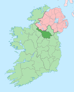 | |
| Villages |
| |
| Townlands | ||
| Landforms | ||
| ||