Bandipora district
| Bandipora بانڈی پُورہ | |
|---|---|
| District | |
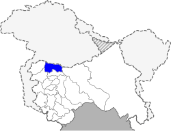 Location in Jammu and Kashmir | |
| Coordinates: 34°25′12″N 74°39′00″E / 34.42000°N 74.65000°ECoordinates: 34°25′12″N 74°39′00″E / 34.42000°N 74.65000°E | |
| Country | India |
| State | Jammu and Kashmir |
| Seat | Bandipora |
| Area | |
| • District | 345 km2 (133 sq mi) |
| • Urban | 49.6 km2 (19.2 sq mi) |
| • Rural | 295.4 km2 (114.1 sq mi) |
| Population (2011)[1] | |
| • District | 392,232 |
| • Density | 1,100/km2 (2,900/sq mi) |
| Time zone | Indian Standard Time |
| Website |
bandipore |
Bandipora district (Urdu; ضلع بانڈی پُورہ) is one of the 22 districts in Jammu and Kashmir state in northern India. Bandipora town is the administrative headquarters of the district. This district was carved out from the erstwhile Baramulla district in 2007. The district is bounded by Kupwara district in the west, Baramulla district in the south and Kargil, Srinagar and Ganderbal districts in the east. This district occupies an area of 398 km².[2] The district has a population of 392,232 as per 2011 census.
Divisions
The district comprises three tehsils: Bandipora, Sumbal Sonawari and Gurez. The district has three Vidhan Sabha constituencies: Gurez, Bandipora and Sonawari. All of these are part of Baramulla Lok Sabha constituency.
Demographics
According to the 2011 census Bandipora district has a population of 385,099,[3] roughly equal to the nation of Maldives.[4] This gives it a ranking of 561st in India (out of a total of 640).[3] The district has a population density of 1,117 inhabitants per square kilometre (2,890/sq mi) .[3] Its population growth rate over the decade 2001-2011 was 26.31%.[3] Bandipora has a sex ratio of 911 females for every 1000 males,[3] and a literacy rate of 57.82%.[3]
Prominent Places
Wular Lake.
Prominent institutions
The largest Islamic seminary of Kashmir Valley Dar-ul-uloom Rahimiya is located in the periphery of Bandipora town. Bandipora is historically famous for three local entities viz. illm (knowledge) , adab (literature) & aab (warer)
References
- ↑ Census of India 2011
- ↑ Srivastava, Dayawanti et al (ed.) (2010). India 2010, A Reference Annual (PDF). New Delhi: Publications Division, Ministry of Information and Broadcasting, Government of Indiaand. p. 1142. ISBN 978-81-230-1617-7.
- 1 2 3 4 5 6 "District Census 2011". Census2011.co.in. 2011. Retrieved 2011-09-30.
- ↑ US Directorate of Intelligence. "Country Comparison:Population". Retrieved 2011-10-01.
Maldives 394,999 July 2011 est.