Kupwara district
| Kupwara ضلع کُپواڑہ | |
|---|---|
| District | |
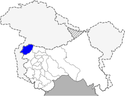 Location of Kupwara District within Jammu and Kashmir state | |
| Country | India |
| State | Jammu and Kashmir |
| Population (2011) | |
| • Total | 875,564 |
| • Density | 368/km2 (950/sq mi) |
Kupwara District (Urdu; ضلع کُپواڑہ) is located in Jammu and Kashmir, India. It shares a long border with Pakistan administered Kashmir in its north and western side and is totally enclosed by Baramulla district on the other side.The district is endowed with rich dense forests. The river 'kishenganga' originating from the Himalayas flows through the outer areas of the district from east to west. Kupwara district has 3 tehsils: Handwara, Karnah and Kupwara.
This district consists of 11 blocks: Sogam, Tangdar, Teetwal, Ramhal, Kupwara, Rajwar, Kralpora, Langate, Wavoora, Trehgam and Kalaroos.[1] Each block consists of a number of panchayats.
Economy
Most of the people depend on agriculture and business is growing feasiblely.(BRGF).[2]
Demographics
According to the 2011 census Kupwara district has a population of 875,564,[3] roughly equal to the nation of Fiji[4] or the US state of Delaware.[5] This gives it a ranking of 470th in India (out of a total of 640).[3] The district has a population density of 368 inhabitants per square kilometre (950/sq mi) .[3] Its population growth rate over the decade 2001-2011 was 34.62%.[3] Kupwara has a sex ratio of 843 females for every 1000 males,[3] and a literacy rate of 66.92%.[3]
Politics
Kupwara District has 5 assembly constituencies: Karnah, Kupwara, Lolab, Handwara and Langate.[6]
Reduced Level
The district is situated at an altitude of 5300 feet above sea level and is the northmost district of Kashmir Valley.
References
- ↑ Statement showing the number of blocks in respect of 22 Districts of Jammu and Kashmir State including newly Created Districts dated 2008-03-13, accessed 2008-08-30
- ↑ Ministry of Panchayati Raj (September 8, 2009). "A Note on the Backward Regions Grant Fund Programme" (PDF). National Institute of Rural Development. Retrieved September 27, 2011.
- 1 2 3 4 5 6 "District Census 2011". Census2011.co.in. 2011. Retrieved 2011-09-30.
- ↑ US Directorate of Intelligence. "Country Comparison:Population". Retrieved 2011-10-01.
Fiji 883,125 July 2011 est.
- ↑ "2010 Resident Population Data". U. S. Census Bureau. Retrieved 2011-09-30.
Delaware 897,934
- ↑ "ERO's and AERO's". Chief Electoral Officer, Jammu and Kashmir. Retrieved 2008-08-28.
External links
 |
Disputed region | | ||
| Disputed region | |
Bandipore district | ||
| ||||
| | ||||
| Baramula district |
Coordinates: 34°31′12″N 74°15′00″E / 34.52000°N 74.25000°E