Belmore Park
| Belmore Park | |
|---|---|
|
Belmore park bounded by Central station and the railway line | |
| Location | Central, New South Wales, Australia |
| Nearest city | Sydney, New South Wales, Australia |
| Coordinates | 33°52′53″S 151°12′28″E / 33.88149°S 151.20769°ECoordinates: 33°52′53″S 151°12′28″E / 33.88149°S 151.20769°E |
| Created | 19 May 1868[1] |
| Operated by | Sydney City Council |
| Status | Open all year |
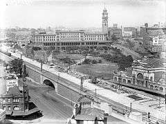
Belmore Park is a public park at the southern end of the Sydney CBD in the Australian state of New South Wales. Adjacent to the Central railway station it is bounded by Hay Street, Eddy Avenue, Elizabeth Street and Pitt Street. The area was previously known as Police Paddock and was part of a section of Crown land which included the Police Barracks, Devonshire Street Cemetery, Female Refuge of the Good Samaritan, Benevolent Asylum and a common. The area was landscaped and in 1868 it opened as a park dedicated to Somerset Lowry-Corry, 4th Earl Belmore the then Governor of New South Wales. In 1901 the whole area was resumed[2] for the construction of Sydney’s Central Railway Station with the majority of excavated earth placed on the common, burying the original layout.[1] During the 1908–09 Royal Commission for the Improvement of the City of Sydney and Its Suburbs major landscaping works for the area were proposed by commissioner Norman Selfe.[3]
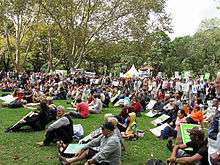
Due to its proximity to the city, and especially to Central Station, the park has long been a place for groups to gather—for protests, markets, events or performances. For example, in 1878 in front of a large crowd, Henri L'Estrange unsuccessfully tried twice to launch himself in a gas balloon, while during the 2000 Summer Olympics the park became one of five "live sites" where the games were publicly broadcast.[4] In the late 1860s "Belmore Produce Markets" and Paddy's Markets were built in the area opposite the current park—now known as Haymarket.
The park is a key public transport hub. The final section of above-ground railway track forms the eastern edge of the park before going underground as the City Circle. All intercity buses from Sydney depart from Eddy Avenue to the south as do many local buses in the direction of the eastern suburbs of Sydney (including express buses to the University of NSW and Bondi). The western edge of the park is defined by a roadway ramp to the concourse level of the train station. The terminus loop of the Inner West Light Rail forms a ring around the entire park using ramps on both eastern and western edges to access the train station concourse.
See also
- Parks in Sydney
- Belmore Park, Goulburn
- Railway Square, Sydney
- Belmore, New South Wales
References
- 1 2 "Belmore Park, Haymarket". Sydney Parks History. City of Sydney. 15 November 2010. Retrieved 30 November 2012.
- ↑ "Appropriated"; as in the Real Property Act 1900 -- Section 31A.
- ↑ Report of the Royal Commission for the Improvement of Sydney and Its Suburbs, New South Wales Parliamentary Papers, vol 5, 1909. Cited in Freyne, Catherine (2009). "Selfe, Norman". Dictionary of Sydney. Retrieved 30 November 2012.
- ↑ Spokes, Hazel (30 September 2000). "Live sites capture the Olympic vibe". Australian Broadcasting Corporation. Retrieved 30 November 2012.
External links
| Wikimedia Commons has media related to Belmore Park, Sydney. |
- Parks History - Belmore Park, by the City of Sydney.
- Maps, forms and documents relating to Belmore Park, by the City of Sydney.
- Virtual tour of Belmore park at Panedia.com
- Catalogue reference in the Dictionary of Sydney