Biery
| Biery | ||
|---|---|---|
| Village | ||
|
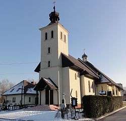
Sacred Heart church | ||
| ||
 Biery | ||
| Coordinates: 49°47′46.9″N 18°54′47.6″E / 49.796361°N 18.913222°E | ||
| Country | Poland | |
| Voivodeship | Silesian | |
| County | Bielsko | |
| Gmina | Jasienica | |
| Government | ||
| • Mayor | Maria Bury | |
| Area | 2.164 km2 (0.836 sq mi) | |
| Population (2009) | 1,233 | |
| • Density | 570/km2 (1,500/sq mi) | |
| Time zone | CET (UTC+1) | |
| • Summer (DST) | CEST (UTC+2) | |
| Car plates | SBI | |
Biery [ˈbjɛrɨ] (German: Bierau) is a village in Gmina Jasienica, Bielsko County, Silesian Voivodeship, southern Poland. It has a population of 1,233 (2009). It lies in the historical region of Cieszyn Silesia.
The village was created in the 16th century by the owners of Grodziec.[1] Originally it was named Birowy, and first appeared on a map from 1563.[2] However other source from 1610, issued by Adam Wenceslaus, Duke of Cieszyn, cites a privilege from 1554, where the village was already supposedly mentioned.[3]
There is a Catholic Heart of Jesus church in the village.
Inventor Józef Bożek was born here in 1782.
Footnotes
- ↑ J. Polak, 2011, p. 9
- ↑ Map of Stanisław Porębski, ca. 1563
- ↑ Panic, Idzi (2011). Śląsk Cieszyński w początkach czasów nowożytnych (1528-1653) [Cieszyn Silesia in Early modern period (1528-1653)] (in Polish). Cieszyn: Starostwo Powiatowe w Cieszynie. p. 165. ISBN 978-83-926929-5-9.
References
- Polak, Jerzy (2011). Obrazki z dziejów gminy Jasienica. Cieszyn: Muzeum Śląska Cieszyńskiego. ISBN 978-83-922005-6-7.
External links
| Wikimedia Commons has media related to Biery. |
Seat: Jasienica | ||
| Other villages | ||


This article is issued from Wikipedia - version of the 3/8/2016. The text is available under the Creative Commons Attribution/Share Alike but additional terms may apply for the media files.