Košařiska
| Košařiska Koszarzyska | |||
|---|---|---|---|
| Village | |||
|
View from the village | |||
| |||
 Location in the Czech Republic | |||
| Coordinates: 49°35′33″N 18°40′46″E / 49.59250°N 18.67944°ECoordinates: 49°35′33″N 18°40′46″E / 49.59250°N 18.67944°E | |||
| Country | Czech Republic | ||
| Region | Moravian-Silesian | ||
| District | Frýdek-Místek | ||
| First mentioned | 1657 | ||
| Government | |||
| • Mayor | Vítězslav Dyrčík | ||
| Area | |||
| • Total | 17.18 km2 (6.63 sq mi) | ||
| Elevation | 458 m (1,503 ft) | ||
| Population (2008) | |||
| • Total | 388 | ||
| • Density | 23/km2 (58/sq mi) | ||
| Postal code | 739 81 | ||
| Website |
www | ||
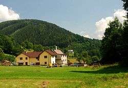
![]() Košařiska (Polish: Koszarzyska ) is a village in Frýdek-Místek District, Moravian-Silesian Region, Czech Republic. It has a population of 365 (2001 census), 38.7% of the population are the Poles.[1] The village lies in the historical region of Cieszyn Silesia and is situated on the Kopytná creek on the foothills of the Moravian-Silesian Beskids mountain range.
Košařiska (Polish: Koszarzyska ) is a village in Frýdek-Místek District, Moravian-Silesian Region, Czech Republic. It has a population of 365 (2001 census), 38.7% of the population are the Poles.[1] The village lies in the historical region of Cieszyn Silesia and is situated on the Kopytná creek on the foothills of the Moravian-Silesian Beskids mountain range.
The name of the village is derived from the word koszarzysko denoting a place where a koszar (movable fence to pen sheep used by Goral shepherds) was placed.[2]
History
The village was first mentioned in 1657 as Kossarzyska.[2][3] It belonged then to the Duchy of Teschen, a fee of the Kingdom of Bohemia and a part of the Habsburg Monarchy.
After Revolutions of 1848 in the Austrian Empire a modern municipal division was introduced in the re-established Austrian Silesia. The village as a municipality was subscribed to the political district of Cieszyn and the legal district of Jablunkov. According to the censuses conducted in 1880, 1890, 1900 and 1910 the population of the municipality dropped from 480 in 1880 to 471 in 1910 with a majority being native Polish-speakers (between 96.8% and 100%) accompanied by German-speaking people (at most 15 or 3.2% in 1880). In terms of religion in 1910 the majority were Protestants (87.7%), followed by Roman Catholics (12.9%).[4]
After World War I, fall of Austria-Hungary, Polish–Czechoslovak War and the division of Cieszyn Silesia in 1920, it became a part of Czechoslovakia. Following the Munich Agreement, in October 1938 together with the Zaolzie region it was annexed by Poland, administratively adjoined to Cieszyn County of Silesian Voivodeship.[5] It was then annexed by Nazi Germany at the beginning of World War II. After the war it was restored to Czechoslovakia.
References
- ↑ "2001 census data". Czech Statistical Office.
- 1 2 Mrózek, Robert (1984). Nazwy miejscowe dawnego Śląska Cieszyńskiego [Local names of former Cieszyn Silesia] (in Polish). Katowice: Uniwersytet Śląski w Katowicach. p. 97. ISSN 0208-6336.
- ↑ Panic, Idzi (2011). Śląsk Cieszyński w początkach czasów nowożytnych (1528-1653) [Cieszyn Silesia in the beginnings of Modern Era (1528-1653)] (in Polish). Cieszyn: Starostwo Powiatowe w Cieszynie. p. 172. ISBN 978-83-926929-5-9.
- ↑ Piątkowski, Kazimierz (1918). Stosunki narodowościowe w Księstwie Cieszyńskiem (in Polish). Cieszyn: Macierz Szkolna Księstwa Cieszyńskiego. pp. 266, 285.
- ↑ "Ustawa z dnia 27 października 1938 r. o podziale administracyjnym i tymczasowej organizacji administracji na obszarze Ziem Odzyskanych Śląska Cieszyńskiego". Dziennik Ustaw Śląskich (in Polish). Katowice. nr 18/1938, poz. 35. 31 October 1938. Retrieved 1 July 2014.
External links
| Wikimedia Commons has media related to Košařiska. |
- (Czech) Official website

