Mosty u Jablunkova
| Mosty u Jablunkova Mosty koło Jabłonkowa | |||
|---|---|---|---|
| Village | |||
|
General view | |||
| |||
 Location in the Czech Republic | |||
| Coordinates: 49°31′34″N 18°45′13″E / 49.52611°N 18.75361°ECoordinates: 49°31′34″N 18°45′13″E / 49.52611°N 18.75361°E | |||
| Country | Czech Republic | ||
| Region | Moravian-Silesian | ||
| District | Frýdek-Místek | ||
| First mentioned | 16th century | ||
| Government | |||
| • Mayor | Josef Szotkowski | ||
| Area | |||
| • Total | 33.95 km2 (13.11 sq mi) | ||
| Elevation | 490 m (1,610 ft) | ||
| Population (2013) | |||
| • Total | 3,937 | ||
| • Density | 120/km2 (300/sq mi) | ||
| Postal code | 739 98 | ||
| Website |
www | ||
.JPG)
![]() Mosty u Jablunkova (Polish: Mosty koło Jabłonkowa , German: Mosty bei Jablunkau) (1920-1949: Mosty)[1] is a village in the Moravian-Silesian Region of the Czech Republic, located in the Jablunkov Pass. It has 3,937[2] inhabitants, 18.3% of the population are the Poles.[3] 83.9% of the population are religious, of whom 93.8% are Catholic. It lies in the historical region of Cieszyn Silesia, on the slopes of the Silesian Beskids mountain range.
Mosty u Jablunkova (Polish: Mosty koło Jabłonkowa , German: Mosty bei Jablunkau) (1920-1949: Mosty)[1] is a village in the Moravian-Silesian Region of the Czech Republic, located in the Jablunkov Pass. It has 3,937[2] inhabitants, 18.3% of the population are the Poles.[3] 83.9% of the population are religious, of whom 93.8% are Catholic. It lies in the historical region of Cieszyn Silesia, on the slopes of the Silesian Beskids mountain range.
The name is cultural in origins literally meaning bridges. It is sometimes conjectured that the name was conveyed by settlers from other village in Cieszyn Silesia also named Mosty, who supposedly established the village. In the past the village was also named Mostarze (1652) denoting rather its inhabitants.[4]
History
The village was first mentioned in 1577 as na Mostach Jablunkowskych.[4][5] It belonged then to the Duchy of Teschen, a fee of the Kingdom of Bohemia and a part of the Habsburg Monarchy.
In 1785 the village became a seat of a Catholic parish.
After Revolutions of 1848 in the Austrian Empire a modern municipal division was introduced in the re-established Austrian Silesia. The village as a municipality was subscribed to the political district of Teschen and the legal district of Jablunkau. According to the censuses conducted in 1880, 1890, 1900 and 1910 the population of the municipality grew from 1,959 in 1880 to 2,318 in 1910 with a majority being native Polish-speakers (growing from 98% in 1880 to 98.5% in 1910) accompanied by German-speaking (at most 38 or 2% in 1880) and Czech-speaking people (at most 7 or 0.3% in 1900). In terms of religion in 1910 the majority were Roman Catholics (98.6%), followed by Protestants (25 or 1.1%) and Jews (6 people).[6] The village was also traditionally inhabited by Silesian Gorals, speaking Jablunkov dialect.
After World War I, fall of Austria-Hungary, Polish–Czechoslovak War and the division of Cieszyn Silesia in 1920, it became a part of Czechoslovakia. Following the Munich Agreement, in October 1938 together with the Zaolzie region it was annexed by Poland, administratively adjoined to Cieszyn County of Silesian Voivodeship.[7]
On August 25/26, 1939 a group of German Military Intelligence (Abwehr) armed agents attacked a rail station in Mosty.
It was annexed by Nazi Germany at the beginning of World War II. After the war it was restored to Czechoslovakia.
Recreation
There are many opportunities for sport and recreation in the village:
- Three pistes with natural and artificial snow and also night skiing
- Small aquapark
- Football field, volleyball fields
- Gym
Transport
Rail
Mosty u Jablunkova has two railway stations, and is served by ČD track 320 from Žilina to Bohumín. Below the highest point of Jablunkov Pass are two railway tunnels 600 meters long.
Bus
Buses connect Mosty u Jablunkova with Jablunkov and Hrčava. There are 18 bus stops in the village.
Car
European road E75 runs through Mosty u Jablunkova from Jablunkov and continues to Slovakia. There is also a customs office on the route, though border checks have been abolished with both countries' accession to the Schengen zone.
Symbols
Coat of arms
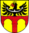
The coat of arms of Mosty u Jablunkova consists of a two-arched red brick bridge in golden shield and a black Silesian eagle.
Flag
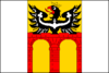
The flag of Mosty u Jablunkova contains three vertical stripes: white, yellow and white in ratio 1:2:1. The yellow stripe contains an unbound reproduction of the coat of arms. The flag ratio is 2:3.
Footnotes
- ↑ Hosák et al. 1980, 99.
- ↑ http://www.mostyujablunkova.cz/soubory/zpravodaj/2013/02_2013.pdf
- ↑ "2001 census data". Czech Statistical Office.
- 1 2 Mrózek, Robert (1984). Nazwy miejscowe dawnego Śląska Cieszyńskiego [Local names of former Cieszyn Silesia] (in Polish). Katowice: Uniwersytet Śląski w Katowicach. p. 120. ISSN 0208-6336.
- ↑ Panic, Idzi (2011). Śląsk Cieszyński w początkach czasów nowożytnych (1528-1653) [Cieszyn Silesia in the beginnings of Modern Era (1528-1653)] (in Polish). Cieszyn: Starostwo Powiatowe w Cieszynie. p. 166. ISBN 978-83-926929-5-9.
- ↑ Piątkowski, Kazimierz (1918). Stosunki narodowościowe w Księstwie Cieszyńskiem (in Polish). Cieszyn: Macierz Szkolna Księstwa Cieszyńskiego. pp. 267, 285.
- ↑ "Ustawa z dnia 27 października 1938 r. o podziale administracyjnym i tymczasowej organizacji administracji na obszarze Ziem Odzyskanych Śląska Cieszyńskiego". Dziennik Ustaw Śląskich (in Polish). Katowice. nr 18/1938, poz. 35. 31 October 1938. Retrieved 1 July 2014.
References
- Hosák, Ladislav; Rudolf Šrámek (1980). Místní jména na Moravě a ve Slezsku II, M-Ž. Praha: Academia.
External links
| Wikimedia Commons has media related to Mosty u Jablunkova. |
- (Czech) Official website
- (Czech) Ski centre Mosty u Jablunkova
- (Czech) Ski centre Mosty u Jablunkova

