Rudnik, Cieszyn County
| Rudnik | ||
|---|---|---|
| Village | ||
|
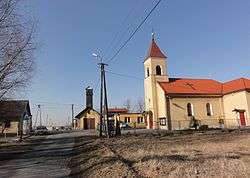
Villages' centre | ||
| ||
 Rudnik | ||
| Coordinates: 49°51′4.1″N 18°40′34.42″E / 49.851139°N 18.6762278°E | ||
| Country | Poland | |
| Voivodeship | Silesian | |
| County | Cieszyn | |
| Gmina | Hażlach | |
| First mentioned | 1523 | |
| Area | 4.105 km2 (1.585 sq mi) | |
| Population (2008) | 453 | |
| • Density | 110/km2 (290/sq mi) | |
| Time zone | CET (UTC+1) | |
| • Summer (DST) | CEST (UTC+2) | |
| Postal code | 43-419 | |
| Car plates | SCI | |
Rudnik [ˈrudnik] is a village in Gmina Hażlach, Cieszyn County, Silesian Voivodeship, southern Poland.[1] It has a population of 453 (2008).
The name of the village is derived from a name of a local stream Rudnik, mentioned as early as 1442 (do potoka jmenem Rudnika), which is a transformation of a word rudy, meaning rdzawy (rusty).[2]
History
It lies in the historical region of Cieszyn Silesia. Up to recently it was stated that the village was first mentioned in 1566 as Rudnik,[2] however another documents exists issued by Wenceslaus III Adam, Duke of Cieszyn on 5 November 1608 which retrospectively affirms another document from 1523 that mentioned the village among others obliged to consume ale produced only in Cieszyn.[3] Politically the village belonged then to the Duchy of Teschen, a fee of the Kingdom of Bohemia, which after 1526 became part of the Habsburg Monarchy.
After World War I, the fall of Austria-Hungary, the Polish–Czechoslovak War and the division of Cieszyn Silesia in 1920, it became a part of Poland. It was then annexed by Nazi Germany at the beginning of World War II. After the war it was restored to Poland.
Geography
Rudnik lies in the southern part of Poland, 11 km (7 mi) north-east of the county seat, Cieszyn, 25 km (16 mi) west of Bielsko-Biała, 55 km (34 mi) south-west of the regional capital Katowice, and 8 km (5.0 mi) east of the border with the Czech Republic.
The village is situated on the geographical border between Ostrava Basin in the east and Oświęcim Basin in the west, between roughly 260–280 m (850–920 ft) above sea level, 16 km (9.9 mi) north-west of the Silesian Beskids. It is drained by several streams, left tributaries of the Knajka, in the watershed of Vistula.
 |
Kończyce Wielkie, Pruchna | Pruchna | Pruchna | |
| Kończyce Wielkie | |
Dębowiec | ||
| ||||
| | ||||
| Kończyce Wielkie Hażlach |
Hażlach | Dębowiec |
References
- ↑ "Central Statistical Office (GUS) – TERYT (National Register of Territorial Land Apportionment Journal)" (in Polish). 2008-06-01.
- 1 2 Mrózek, Robert (1984). Nazwy miejscowe dawnego Śląska Cieszyńskiego [Local names of former Cieszyn Silesia] (in Polish). Katowice: Uniwersytet Śląski w Katowicach. p. 153. ISSN 0208-6336.
- ↑ Panic, Idzi (2010). Śląsk Cieszyński w średniowieczu (do 1528) [Cieszyn Silesia in Middle Ages (until 1528)] (in Polish). Cieszyn: Starostwo Powiatowe w Cieszynie. p. 311. ISBN 978-83-926929-3-5.
| Wikimedia Commons has media related to Rudnik, Cieszyn County. |
Seat: Hażlach | ||
| Other villages | ||

