Doubrava (Karviná District)
| Doubrava | |||
|---|---|---|---|
| Village | |||
|
Národní dům (National House) | |||
| |||
 Location in the Czech Republic | |||
| Coordinates: 49°51′33″N 18°28′11″E / 49.85917°N 18.46972°E | |||
| Country | Czech Republic | ||
| Region | Moravian-Silesian | ||
| District | Karviná | ||
| First mentioned | 1229 | ||
| Government | |||
| • Mayor | Pavel Krsek | ||
| Area | |||
| • Total | 7.77 km2 (3.00 sq mi) | ||
| Elevation | 235 m (771 ft) | ||
| Population (2012) | |||
| • Total | 1,273 | ||
| • Density | 160/km2 (420/sq mi) | ||
| Postal code | 735 33 | ||
| Website | Official website | ||

_vlajka.jpg)
_znak.jpg)
![]() Doubrava (1920-1924: Dombrová)[1] (Polish: Dąbrowa , German: Dombrau) is a village in Karviná District, Moravian-Silesian Region, Czech Republic. It has a population of 1,507 (2006) and lies in the historical region of Cieszyn Silesia.
Doubrava (1920-1924: Dombrová)[1] (Polish: Dąbrowa , German: Dombrau) is a village in Karviná District, Moravian-Silesian Region, Czech Republic. It has a population of 1,507 (2006) and lies in the historical region of Cieszyn Silesia.
The name of the village comes from the Slavic for "oak" (Polish: dąb, Czech: dub) and means "oak forest".
History
It is not clear when the village was founded. It was first mentioned in the document of Pope Gregory IX issued in 1229 among villages belonging to Benedictine abbey in Tyniec, as Dubrowa.[2] In 1268 it was bestowed by Władysław Opolski to the newly established Benedictine abbey in Orlová.
Politically it belonged then to the Duchy of Opole and Racibórz and Castellany of Cieszyn, which was in 1290 formed in the process of feudal fragmentation of Poland and was ruled by a local branch of Piast dynasty. In 1327 the duchy became a fee of the Kingdom of Bohemia, which after 1526 became part of the Habsburg Monarchy. In 1573 it was sold as one of a dozen villages and the town of Freistadt and formed a state country split from the Duchy of Teschen.[3]
During the Middle Ages the village changed hands often. From 1746 to 1901 it belonged to the Mattencloit family, who in 1901 sold it to a member of the Viennese banking family the Rothschilds.
An important milestone in the history of the village was the discovery of coal in 1822. The digging of small coal mines began, most of which were later abandoned. In 1854–1855 two mines were dug, christened Eleonora and Bettina. The majority of the local population worked in the coal mining industry. The local coal mines were later consolidated into a joint venture, Důl Doubrava (Doubrava Coal Mine). Tower of Bettina coal mine was detonated on 23 October 2006, tower of Eleonora coal mine was detonated on 2 November 2007.
After Revolutions of 1848 in the Austrian Empire a modern municipal division was introduced in the re-established Austrian Silesia. The village as a municipality was subscribed at first to the political district of Teschen and the legal district of Freistadt, which in 1868 became an independent political district. The municipality gained market town status in the meantime.
According to the censuses conducted in 1880, 1890, 1900 and 1910 the population of the municipality grew from 2,382 in 1880 to 5,660 in 1910. The censuses asked people for their native language, the answers were shifting throughout the years. At first majority were Czech-speaking (2,004 or 85.6% in 1880 and 1,987 or 66.2% in 1890, then dropping to 823 or 19.6% and again growing to 1,911 or 34.7% in 1910), later Polish-speaking (at first 286 or 12.2% in 1880, then 893 or 29.8% in 1890, and 3,258 or 77.7% in 1900, 3,453 or 62.8% in 1910). They were accompanied by a German-speaking minority (in percentage at most 120 or 4% in 1890, in number 138 or 2.5% in 1910). In terms of religion in 1910 the majority were Roman Catholics (5,159 or 91.1%), followed by Protestants (354 or 6.3%), Jews (134 or 2.4%) and 13 others.[4] The village was also traditionally inhabited by Silesian Lachs, speaking Cieszyn Silesian dialect, additionally industrial growth lured a large influx of migrant workers, mostly from western Galicia.
After World War I, fall of Austria-Hungary, Polish–Czechoslovak War and the division of Cieszyn Silesia in 1920, the village became a part of Czechoslovakia. Following the Munich Agreement, in October 1938 together with the Zaolzie region it was annexed by Poland, administratively organised in Frysztat County of Silesian Voivodeship.[5] The village was then annexed by Nazi Germany at the beginning of World War II. After the war it was restored to Czechoslovakia.
In 1974 Doubrava was administratively joined to the town of Orlová. Living conditions in Doubrava deteriorated during the Communist era as a result of extensive coal mining. In 1990 it once again became an independent municipality.
The most important landmarks in the village are the Roman Catholic church devoted to Saint Hedvika, consecrated in 1899, the 1928 Czechoslovak Hussite church, and Národní dům (National House), built in 1903 to serve cultural and sporting purposes.
Gallery
 Memorial to local World War I victims
 Saint Hedvika Church
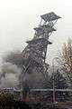 Detonation of tower of Eleonora coal mine
People
- Jan Buzek, Polish physician and politician, worked in the village.
- Józef Kiedroń, Polish engineer and politician, worked in the village.
See also
Footnotes
- ↑ Hosák et al. 1970, 190-191.
- ↑ Panic, Idzi (2010). Śląsk Cieszyński w średniowieczu (do 1528) [Cieszyn Silesia in the Middle Ages (until 1528)] (in Polish). Cieszyn: Starostwo Powiatowe w Cieszynie. p. 286. ISBN 978-83-926929-3-5.
- ↑ Panic, Idzi (2011). Śląsk Cieszyński w początkach czasów nowożytnych (1528-1653) [Cieszyn Silesia in the beginnings of Modern Era (1528-1653)] (in Polish). Cieszyn: Starostwo Powiatowe w Cieszynie. pp. 226–227. ISBN 978-83-926929-5-9.
- ↑ Piątkowski, Kazimierz (1918). Stosunki narodowościowe w Księstwie Cieszyńskiem (in Polish). Cieszyn: Macierz Szkolna Księstwa Cieszyńskiego. pp. 273, 290.
- ↑ "Ustawa z dnia 27 października 1938 r. o podziale administracyjnym i tymczasowej organizacji administracji na obszarze Ziem Odzyskanych Śląska Cieszyńskiego". Dziennik Ustaw Śląskich (in Polish). Katowice. nr 18/1938, poz. 35. 31 October 1938. Retrieved 1 July 2014.
References
- Chlup, Danuta (2007-09-27). "Wioska powraca do życia". Głos Ludu. p. 1.
- Hosák, Ladislav; Rudolf Šrámek (1970). Místní jména na Moravě a ve Slezsku I, A-L. Praha: Academia.
- "Na Doubravě padne druhá těžní věž". OKD. 2007-11-01.
External links
| Wikimedia Commons has media related to Doubrava. |
- (Czech) Official website


Coordinates: 49°51′33″N 18°28′11″E / 49.85917°N 18.46972°E