Binfield Heath
| Binfield Heath | |
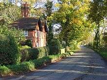
 The Bottle and Glass public house |
|
 Binfield Heath |
|
| Area | 6.13 km2 (2.37 sq mi) |
|---|---|
| Population | 709 (2011)[1] |
| – density | 116/km2 (300/sq mi) |
| OS grid reference | SU7478 |
| Civil parish | Shiplake |
| District | South Oxfordshire |
| Shire county | Oxfordshire |
| Region | South East |
| Country | England |
| Sovereign state | United Kingdom |
| Post town | Reading |
| Postcode district | RG9 |
| Dialling code | 0118 |
| Police | Thames Valley |
| Fire | Oxfordshire |
| Ambulance | South Central |
| EU Parliament | South East England |
| UK Parliament | Henley |
| Website | Binfield Heath |
|
|
Coordinates: 51°30′34″N 0°55′25″W / 51.5095°N 0.9235°W
Binfield Heath is a village and civil parish in South Oxfordshire, England. It is centred 2.6 miles (4.2 km) SSW of Henley-on-Thames and 3.6 miles (5.8 km) northeast of Reading, Berkshire (the nearest towns) and is on a southern knoll of the Chiltern Hills. The village has a Congregational Church, ground for polo, Michelin star chef-run restaurant and public house. Twelve of its 294 homes (as at the 2011 census) are listed, one of which is a BBC Georgian mansion with a separately listed garden grotto and saw a significant decline in its use in the year 2014.
Creation as a village
Until 2003, Half of Binfield Heath and the hamlet of Crowsley were the western part of the civil parish of Shiplake with the rest in the parish of Eye & Dunsden. This almost exactly rectangular tract of land acquired its own civil parish in 2003. Having some other amenities, Binfield Heath meets the criteria of a village — omitting the old criterion of an Anglican place of worship to give the contemporary definition of a village. The central community is green buffered but not isolated, as it is a relatively small knoll in the foothills of the Chiltern Hills: Dunsden church is 0.5 miles (0.80 km) south-west and both communities are combined with the ecclesiastical parish today of Shiplake.[2]
Geography
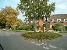
Binfield Heath has an almost continuous street of Victorian properties, Shiplake Row, which leads 0.5 miles (0.80 km) and descends 25 metres to the nucleus of the larger village of Shiplake by the River Thames. The village has an independent Christian place of worship covering a larger ecclesiastical area of its own, a Congregational church.[3]
The village nucleus (it has some dispersed clusters) is centred SSW of Henley-on-Thames and 3.6 miles (5.8 km) northeast of Reading, Berkshire, the nearest towns.[4]
Crowsley Park Wood is the parish's largest woodland and is the opposite side of the village from the combined 'Comp Wood, The Common and Oakhouse Wood' and the field-surrounded Kings Common woodland.
Landmarks

The Crowsley Park estate, including a Grade II (initial category) listed, 18th century mansion house, a grotto, barns and a stable, is west of the village centre which has the vast majority of buildings in the village. In the heart of the village and to the west and south are eleven other homes, equally listed: Jasmine Cottage, Freize Farmhouse, The Well House, Fir Tree Cottage, Thatched Cottage, Shiplake Rise Cottage, Holmwood, The Bottle and Glass, The Old House, Coppice Cottage, Elm Tree Farmhouse, Hampstead Farm Stable, and seven barns.[5]
Congregational church
The Congregational Church was built in a Gothic Revival style in 1835, an early embellished example of what was considered a nonconformist and which remains a Protestant place of worship.[6]
Amenities
- Public house: the Bottle and Glass
- Restaurant: Orwells open since 2010, of Michelin-starred chef, Ryan Simpson.[7]
- Polo club and horse riding lessons.[8]
Demography
The population rose by 9.6% in the ten years to 2011 (from 643 in 2001 to 709).
| Output area | Population | Homes | % Owned outright | % Owned with a loan | km² | km² Greenspace[n 1] | km² gardens | km² road and rail[1] |
|---|---|---|---|---|---|---|---|---|
| Binfield Heath (civil parish) | 709 | 294 | 53.7% | 36.1% | 6.13 | 5.62 | 0.22 | 0.10 |
Nearest places
 |
Rotherfield Peppard | Harpsden (part of) | Harpsden (part of) | |
| Sonning Common | |
Shiplake | ||
| ||||
| | ||||
| Caversham | (Sonning) Eye and Dunsden | (Sonning) Eye and Dunsden |
Notes and references
- Notes
- ↑ Comprises here cultivated fields, woodland, pasture, a public green and no marshland.
- References
- 1 2 Key Statistics: Dwellings; Quick Statistics: Population Density; Physical Environment: Land Use Survey 2005
- ↑ Parish of Binfield Heath The Church of England. Retrieved 2014-11-27
- ↑ Binfield Heath website
- ↑ Grid Reference Finder distance tools
- ↑ Listed Buildings Mapsearch English Heritage. Retrieved 2014-11-27
- ↑ Sherwood, Jennifer; Pevsner, Nikolaus (1974). The Buildings of England: Oxfordshire. Harmondsworth: Penguin Books. p. 590. ISBN 0-14-071045-0.
- ↑ Orwells Restaurant
- ↑ Binfield Heath Polo Club
External links
![]() Media related to Binfield Heath at Wikimedia Commons
Media related to Binfield Heath at Wikimedia Commons