Black Rock Bridge
|
Black Rock Bridge | |
|
Black Rock Bridge, January 2010 | |
  | |
| Location | Pennsylvania Route 113 over the Schuylkill River, Phoenixville and Upper Providence Township, Pennsylvania |
|---|---|
| Coordinates | 40°9′32″N 75°30′44″W / 40.15889°N 75.51222°WCoordinates: 40°9′32″N 75°30′44″W / 40.15889°N 75.51222°W |
| Area | less than one acre |
| Built | 1927 |
| Built by | Wagman, G.A.; Wagman, F.M. |
| Architectural style | Other, Multi-span spandrel arch |
| MPS | Highway Bridges Owned by the Commonwealth of Pennsylvania, Department of Transportation TR |
| NRHP Reference # | 88000735[1] |
| Added to NRHP | June 22, 1988 |
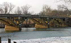
Black Rock Bridge is a historic concrete arch bridge carrying Pennsylvania Route 113 across the Schuylkill River between Phoenixville, Chester County, Pennsylvania, and Upper Providence Township, Montgomery County, Pennsylvania. It has five spans; three main spans are each 116 feet (35 m) long and flanked by two 103-foot-long (31 m) spans. The bridge was constructed in 1927, and features open-spandrel arches and solid concrete parapet walls.[2]
It was listed on the National Register of Historic Places in 1988.[1]
References
- 1 2 National Park Service (2010-07-09). "National Register Information System". National Register of Historic Places. National Park Service.
- ↑ "National Historic Landmarks & National Register of Historic Places in Pennsylvania" (Searchable database). ARCH: Pennsylvania's Historic Architecture & Archaeology. Retrieved 2012-11-02. Note: This includes District 6-0 (November 1982). "Pennsylvania Historic Resource Survey Form: Black Rock Bridge" (PDF). Retrieved 2012-10-08.
| Crossings of the Schuylkill River | ||||
|---|---|---|---|---|
| ||||
| Topics |   | |
|---|---|---|
| Lists by county |
| |
| Lists by city | ||
| Other lists | ||
| ||
This article is issued from Wikipedia - version of the 11/29/2016. The text is available under the Creative Commons Attribution/Share Alike but additional terms may apply for the media files.