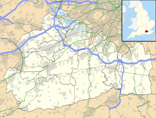
Bletchingley
| Bletchingley | |
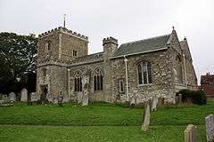 Medieval Church - grade I listed[1] |
|
 Bletchingley |
|
| Area | 23.45 km2 (9.05 sq mi) |
|---|---|
| Population | 2,973 (Civil Parish 2011)[2] |
| – density | 127/km2 (330/sq mi) |
| OS grid reference | TQ327507 |
| Civil parish | Bletchingley |
| District | Tandridge |
| Shire county | Surrey |
| Region | South East |
| Country | England |
| Sovereign state | United Kingdom |
| Post town | Redhill |
| Postcode district | RH1 |
| Dialling code | 01883 |
| Police | Surrey |
| Fire | Surrey |
| Ambulance | South East Coast |
| EU Parliament | South East England |
| UK Parliament | East Surrey |
Coordinates: 51°14′28″N 0°05′56″W / 51.241°N 0.099°W
Bletchingley (historically "Blechingley") is a village in Surrey, England. It is on the A25 road to the east of Redhill and to the west of Godstone, has a conservation area with medieval buildings and is mostly on a wide escarpment of the Greensand Ridge, which is followed by the Greensand Way.
History
The village lay within the Anglo-Saxon administrative division of Tandridge hundred.
The settlement appears in the Domesday Book as Blachingelei. It was held by Richard de Tonebrige. Its Domesday Assets were: 3 hides; 14 ploughs, 17 acres (69,000 m2) of meadow, woodland worth 58 hogs. Also 7 houses in London and Southwark. It rendered (in total): £15 13s 4d.[3]
In 1225 there is mention of Bletchingley as a borough. In the Middle Ages a borough was created by either the King or a Lord as a potentially profitable element in the development of their estates.
It appears that after the 14th century Bletchingley began to lose its importance as a borough, perhaps losing out to the market town of Reigate. The village retained its status as a parliamentary borough and elected two members to the unreformed House of Commons. By the time of the Industrial revolution, it had become a rotten borough. Parliamentary elections were held from 1733 in what is now the White Hart inn: a book in 1844 notes this and that 8 to 10 people voted, as well as a sale of the manor for a very disproportionate sum of £60,000 in 1816.[4]
The house at Place Farm formed the gatehouse of Bletchingley Place: a great Tudor house, which Anne of Cleves occupied after her marriage to Henry VIII was annulled.
There are still several buildings that date back to around 1500 in the High Street main area of Bletchingley, comprising some 90 or so houses.[5]
Amenities

The nearest railway station, Nutfield, is about 2 miles (3 km) away in South Nutfield.
Bletchingley is architecturally and topologically distinct: the central part of the village is a conservation area with several buildings timber-framed from the late Middle Ages and the village is set in a designated area of outstanding natural beauty (AONB). The Greensand Way runs fairly centrally through the parish, immediately south of the main village street which is part of the A25 road.
Church
St Mary the Virgin Church is just north of the crossroads of the village. Four of the monuments in the churchyard are listed at Grade II, all of them tombs. The reasons for its Grade I listing[1] are:
- 11th-century tower (ironstone rubble with ashlar dressings); north arcade and south chancel chapel 13th century with 15th-century alterations
- North aisle by Rohde Hawkins, 1856
- Renewed upper stage of tower by Baker-King in 1910
- Elaborate/Romantic 19th-century aisle windows
- Perpendicular style windows
- Gargoyles to the angles.
- Three-light head window to chancel chapel associated with Roger the Hermit of Bletchingley
- Stone human head stops to hood moulding of west door
- Renewed south door under 15th-century roll-moulded surround in rich battlemented and crocketed Perpendicular porch.[1]
Localities in the parish
Warwick Wold
Warwick Wold is a hamlet immediately southeast of the M25 motorway/M23 motorway interchange and separated by a green buffer from Bletchingley by Lower Pendell Farm, which holds in one of its fields ruins of a Roman house, Lake Farm and Brewer Street Farm.[5]
Pendell House, Pendell Court, and the Old Manor House
Pendell House was designed for Richard Glydd by Inigo Jones to a symmetrical plan. On one of the chimney stacks is the date 1636. Glydd died in 1665, and his grandson John, an MP for Blechingley, came into possession. He died without issue in 1689, and his mother and sister Ann Glydd sold the house to Andrew Jelf, who was succeeded by Captain Andrew Jelf, R.N. His daughters sold it to Joseph Seymour Biscoe in 1803 and he sold to John G. W. Perkins in 1811. On the intestate death of his son John Perkins in 1846 it was the share of his sister, who left it to her sister's grandson Jarvis Kenrick, who lived there in 1911. This is a Grade I listed building, the highest category of architectural listing in the country.[6]
Directly opposite the main road is George Holman's 1624-built larger Pendell Court,[7] built of red brick with stone mullioned windows and tiled roof, marble fireplaces and woodwork,[8] and now used as the main building of a private school, [www.hawthorns.com/ The Hawthorns Preparatory School (ages 2–13)].
Backing on to the school along the same partly paved street is a 16th-century house, brown-brick clad, timber framed, refronted in those bricks and extended in the 18th century, with Grade II* listing, known as the Manor House.[9] Above this is a stone coped parapet partially obscuring a plain tiled roof with stone coped gables.[9]
Brewerstreet or Brewer Street
Only 0.6 miles (1.0 km) north of the village, reached by the road at the east end of the churchyard, is Brewerstreet Farm and the old Rectory, parts of which date from the end of the 17th century.[n 1][10] The house is a two-storey, partly slate-roofed structure that underwent a complete transformation about the middle of the 18th century. In one of the upper rooms is a stone fireplace with a moulded four-centred head and jambs. Grade II listed, the house has three diagonal 17th century chimney stacks to the old left section at the point where it meets the new. In keeping, its central doubled glazed doors has a Doric fluted pilaster (column) surround under flat porch hood.[11]
Brewerstreet Farm is a Grade I listed building house, part 15th century, part Tudor; alterations and extension in 1850; further restoration in the 20th century. Close stud timber framed on a brick plinth with rendered infill, the roof is hipped of Horsham stone, with three symmetrically chimney stacks. A former medieval hall house, it has gabled end cross wings with jettied first floors, curly bargeboards and moulded dragon posts to stairwell corners.[12]
Demography and housing
| Output area | Detached | Semi-detached | Terraced | Flats and apartments | Caravans/temporary/mobile homes | shared between households[2] |
|---|---|---|---|---|---|---|
| (Civil Parish) | 365 | 546 | 190 | 129 | 6 | 0 |
The average level of accommodation in the region composed of detached houses was 28%, the average that was apartments was 22.6%.
| Output area | Population | Households | % Owned outright | % Owned with a loan | hectares[2] |
|---|---|---|---|---|---|
| (Civil Parish) | 2,973 | 1,236 | 30.5% | 35.4% | 2,345 |
The proportion of households in the civil parish who owned their home outright compares to the regional average of 35.1%. The proportion who owned their home with a loan compares to the regional average of 32.5%. The remaining % is made up of rented dwellings (plus a negligible % of households living rent-free).
Governance
There is one representative on Surrey County Council, Conservative Tony Elias whose extensive ward is called Godstone.[13] There are three representatives on Tandridge District Council:
| Member Since | Member[14] |
Ward | |
|---|---|---|---|
| 2007 | Gill Black | Bletchingley & Nutfield | |
| 2006 | Tony Edouard Elias | Bletchingley & Nutfield | |
| 1998 | Marian Eva Patricia Myland | Bletchingley & Nutfield | |
There is also a parish council with 9 members.[15]
Nearest settlements
 |
Merstham | Chaldon | Caterham | |
| Nutfield | |
Godstone | ||
| ||||
| | ||||
| South Nutfield, Nutfield | Outwood | Blindley Heath and South Godstone, Godstone |
Notes and references
- Notes
- ↑ Although H.E. Malden in 1911 says parts of the Old Rectory " appear to date from the end of the 15th century"
- References
- 1 2 3 Historic England. "Church of St Mary the Virgin (1029972)". National Heritage List for England. Retrieved 6 June 2015.
- 1 2 3 Key Statistics; Quick Statistics: Population Density United Kingdom Census 2011 Office for National Statistics Retrieved 21 November 2013
- ↑ Surrey Domesday Book Archived 30 October 2007 at the Wayback Machine.
- ↑ Brayley, Edward Wedlake (1844). The history of Surrey, Volume 4, Part 1. p. 114.
- 1 2 Ordnance Survey map, courtesy of English Heritage
- ↑ Historic England. "Pendell House (1029987)". National Heritage List for England. Retrieved 6 June 2015.
- ↑ Stone tablet over the entrance porch of Pendell Court
- ↑ Historic England. "The Hawthornes Pendell Court (1281104)". National Heritage List for England. Retrieved 6 June 2015.
- 1 2 Historic England. "The Manor House (1204686)". National Heritage List for England. Retrieved 6 June 2015.
- ↑ H.E. Malden (editor) (1912). "Parishes: Blechingley". A History of the County of Surrey: Volume 4. Institute of Historical Research. Retrieved 6 November 2012.
- ↑ Historic England. "The Old Rectory including west wing (1377508)". National Heritage List for England. Retrieved 6 June 2015.
- ↑ Historic England. "Brewer Sreet Farm House (1281258)". National Heritage List for England. Retrieved 6 June 2015.
- ↑ "List of Surrey CC Councillors". Surrey County Council. Retrieved 28 April 2012.
- ↑ "Council Members". Tandridge District Council. Retrieved 28 April 2012.
- ↑ "Bletchingley Parish Councillors". Bletchingley Parish Council. Retrieved 28 April 2012.
Further reading
- Uvedale Lambert (1921), Blechingley, a Parish History. London: Mitchell, Hughes and Clark. (vol 1, vol 2). OCLC 5385147
External links
| Wikimedia Commons has media related to Bletchingley. |
| Settlements (grouped by associated post town) |
|  | ||||||||||||||||||||||||||||||||||
|---|---|---|---|---|---|---|---|---|---|---|---|---|---|---|---|---|---|---|---|---|---|---|---|---|---|---|---|---|---|---|---|---|---|---|---|---|
| Places of worship | ||||||||||||||||||||||||||||||||||||
| Education | ||||||||||||||||||||||||||||||||||||
| Transport |
| |||||||||||||||||||||||||||||||||||
| Buildings and structures |
| |||||||||||||||||||||||||||||||||||
| Sport |
| |||||||||||||||||||||||||||||||||||
The administrative centre is Oxted. The largest town is Caterham. Three of the post towns have urban centres Caterham, Godstone and Oxted. Lingfield and Warlingham are major villages which have post town status. The others are outside the area. | ||||||||||||||||||||||||||||||||||||