Boston Post Road Historic District (Rye, New York)
|
Boston Post Road Historic District | |
|
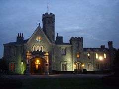
Whitby Castle, one of three antebellum mansions in the Boston Post Road Historic District | |
  | |
| Location | Rye, New York |
|---|---|
| Built | 1838-1854 |
| Architect | Multiple |
| Architectural style | Gothic Revival, Greek Revival |
| NRHP Reference # | 82001275 |
| Significant dates | |
| Added to NRHP | October 29, 1982[1] |
| Designated NHLD | August 30, 1993[2] |
The Boston Post Road Historic District is a historic district including three pre-Civil War mansions and their grounds, a 10,000-year-old Paleo-Indian meadow and viewshed, a cemetery, and a nature preserve. It touches on the south side of the nation's oldest road, the Boston Post Road (US 1) in Rye, New York, where mile marker "24" out of 230, designated in 1763 by Benjamin Franklin, is set into the perimeter wall; from there the landmarked area of 286 acres (1.16 km2) expands down to the Milton Harbor of the Long Island Sound. Two of the mansions included in the landmark district are Greek Revival; the third is Gothic Revival and was designed by Alexander Jackson Davis.
This site with its archaeological significance and importance to American heritage was declared a National Historic Landmark in 1993.[2][3] The three-quarters-mile (1.2 km) meadow and viewshed is one of fewer than a dozen such identified Paleo-Indian sites in all of New York State.[4]
Included within the district are the following historic structures, associated buildings and grounds:
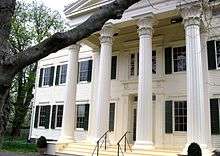
- The 1838 Peter Augustus Jay House, now being restored by the not-for-profit Jay Heritage Center, is one of two Greek Revival residences. It is situated on the Jay Property, the boyhood home of American Founding Father John Jay. The existing house was built upon the footprint of an older 18th-century farmhouse, "The Locusts", and replaced with the current mansion by John Jay's eldest son, Peter Augustus Jay. The mansion was erected according to specifications in a contract between Jay and a builder named Edwin Bishop, and details appear to have been drawn from architectural pattern books by Minard Lafever and Chester Hills.[3]:13 Restoration of the house is an official Save America's Treasures project. The site is on the Westchester County African American Heritage Trail, and was designated a member site of the Hudson River Valley National Heritage Area in January 2009. The house and property are open to the public.
- 1907 Van Norden Carriage House(designed by Frank A. Rooke)
- 1907 Zebra House(designed by Frank A. Rooke)
- Tennis House (1917 or earlier)
- Estate Cottage on Barlow Lane (19th century or earlier)
- Summer House (1957-8, non-contributing)
- Estate Cottage B (demolished)
- Bowling Alley (demolished)
- Four outbuildings (demolished)
- Gazebo (demolished)
- Gardens designed by Jay family, Brinley & Holbrook and others; includes stone ha-ha walls (1822).
- Lounsberry (1831), also known as the Parsons House, is a second Greek Revival residence in the district; notably it has a library designed by Delano & Aldrich
- Gardener's Cottage
- Carriage House and Stable
- Outbuilding with five bays
- Poultry and Wood House
- Greenhouse
- Whitby Castle (1854), Gothic Revival residence, which is now the City of Rye Golf Club. This was designed by Alexander Jackson Davis for William Chapman
- Caretaker's house
- Pool house and golf cart garage (non-contributing)
- Starter's House (non-contributing)
- Maintenance building (non-contributing)
Also included are:
- Jay Family Cemetery (1805, three acres [1.2 ha])
- Marshlands Conservancy (created in 1967; formerly part of the original Jay family estate, 137 acres [55 ha])
See also
References
- ↑ National Park Service (2007-01-23). "National Register Information System". National Register of Historic Places. National Park Service.
- 1 2 "Boston Post Road Historic District". National Historic Landmark summary listing. National Park Service. 2007-09-14. Archived from the original on 2007-12-14.
- 1 2 Karen Kennedy and Austin O'Brien (December 12, 1986), National Register of Historic Places Inventory-Nomination: Boston Post Road Historic District (pdf), National Park Service and Accompanying 33 photos, exteriors and interiors, from 1979-1983. (7.94 MB)
- ↑ Pfeiffer, John (April 21, 1982). Preliminary Archaeological Survey of the Boston Post Road Historic District of Rye, NY. p. 2.
External links
- Historic American Buildings Survey (HABS) No. NY-4115, "Parsons-Lounsbury House, Boston Post Road, Rye, Westchester County, NY", 5 photos, 15 measured drawings, 4 data pages, supplemental material
- Jay Family Cemetery
- Hudson River Valley National Heritage Area
- Westchester County African American Heritage Trail
- Library of Congress - Local Legacies - Jay Heritage Center
Coordinates: 40°57′31″N 73°42′07″W / 40.958487°N 73.701922°W
| Topics |  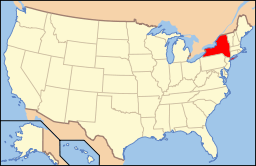 | |
|---|---|---|
| Lists by county |
| |
| Lists by city | ||
| Other lists | ||
| ||