Bramans
| Bramans | |
|---|---|
|
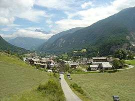
A general view of Bramans | |
 Bramans | |
|
Location within Auvergne-Rhône-Alpes region  Bramans | |
| Coordinates: 45°13′28″N 6°46′35″E / 45.2244°N 6.7764°ECoordinates: 45°13′28″N 6°46′35″E / 45.2244°N 6.7764°E | |
| Country | France |
| Region | Auvergne-Rhône-Alpes |
| Department | Savoie |
| Arrondissement | Saint-Jean-de-Maurienne |
| Canton | Lanslebourg-Mont-Cenis |
| Intercommunality | Haute Maurienne-Vanoise |
| Government | |
| • Mayor (2008–2014) | Yvon Claraz |
| Area1 | 92.26 km2 (35.62 sq mi) |
| Population (2006)2 | 393 |
| • Density | 4.3/km2 (11/sq mi) |
| Time zone | CET (UTC+1) |
| • Summer (DST) | CEST (UTC+2) |
| INSEE/Postal code | 73056 / 73500 |
| Elevation | 1,194–3,378 m (3,917–11,083 ft) |
| Website | Bramans.fr |
|
1 French Land Register data, which excludes lakes, ponds, glaciers > 1 km² (0.386 sq mi or 247 acres) and river estuaries. 2 Population without double counting: residents of multiple communes (e.g., students and military personnel) only counted once. | |
Bramans is a commune in the Savoie department in the Auvergne-Rhône-Alpes region in south-eastern France.
Twin towns — Sister cities
Bramans is twinned with:
-
 Giaglione, Italy (2010)
See also
References
External links
| Wikimedia Commons has media related to Bramans. |
This article is issued from Wikipedia - version of the 10/28/2016. The text is available under the Creative Commons Attribution/Share Alike but additional terms may apply for the media files.