Apremont, Savoie
| Apremont | ||
|---|---|---|
|
The road into Apremont | ||
| ||
 Apremont | ||
|
Location within Auvergne-Rhône-Alpes region  Apremont | ||
| Coordinates: 45°30′54″N 5°57′29″E / 45.515°N 5.958°ECoordinates: 45°30′54″N 5°57′29″E / 45.515°N 5.958°E | ||
| Country | France | |
| Region | Auvergne-Rhône-Alpes | |
| Department | Savoie | |
| Arrondissement | Chambéry | |
| Canton | Montmélian | |
| Area1 | 17.76 km2 (6.86 sq mi) | |
| Population (2006)2 | 964 | |
| • Density | 54/km2 (140/sq mi) | |
| Time zone | CET (GMT +1) (UTC+1) | |
| • Summer (DST) | CEST (UTC+2) | |
| INSEE/Postal code | 73017 / 73190 | |
| Dialling codes | 0479 | |
| Elevation |
302–1,554 m (991–5,098 ft) (avg. 330 m or 1,080 ft) | |
| Website | www.mairie-apremont.com | |
|
1 French Land Register data, which excludes lakes, ponds, glaciers > 1 km² (0.386 sq mi or 247 acres) and river estuaries. 2 Population without double counting: residents of multiple communes (e.g., students and military personnel) only counted once. | ||
.JPG)
.svg.png)
Apremont is a commune in the Savoie department in the Auvergne-Rhône-Alpes region in south-eastern France.
It lies southeast of Chambéry.
Demography
| Year | 1962 | 1968 | 1975 | 1982 | 1990 | 1999 | 2006 |
|---|---|---|---|---|---|---|---|
| Population | 558 | 558 | 696 | 777 | 781 | 890 | 964 |
Vineyards
In the night of 24 November 1248, a massive landslide remodelled the lands of the commune and created a distinctive environment for growing grapes. At an altitude of 350 metres and catching the morning sun, the vines of Apremont, together with the adjoining communes of Saint-André-les-Marches and Saint-Baldoph have been productive for centuries and are now the major producer in Savoy with around 400 hectares in cultivation. The chalky soil is particularly favourable to white wines, which predominate.
-

La Cluse de Chambéry and la Combe de Savoie seen from Apremont
-
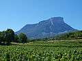
Le Granier and vineyards of Apremont.
See also
References
External links
| Wikimedia Commons has media related to Apremont (Savoie). |