Champagny-en-Vanoise
| Champagny-en-Vanoise | |
|---|---|
|
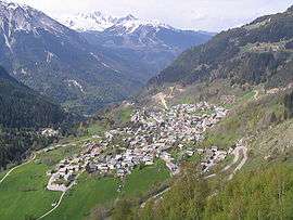
An aerial view of Champagny-en-Vanoise | |
 Champagny-en-Vanoise | |
|
Location within Auvergne-Rhône-Alpes region  Champagny-en-Vanoise | |
| Coordinates: 45°27′19″N 6°41′36″E / 45.4553°N 6.6933°ECoordinates: 45°27′19″N 6°41′36″E / 45.4553°N 6.6933°E | |
| Country | France |
| Region | Auvergne-Rhône-Alpes |
| Department | Savoie |
| Arrondissement | Albertville |
| Canton | Bozel |
| Intercommunality | Val Vanoise |
| Government | |
| • Mayor (2008–2014) | René Ruffier Lanche |
| Area1 | 84.96 km2 (32.80 sq mi) |
| Population (2006)2 | 678 |
| • Density | 8.0/km2 (21/sq mi) |
| Time zone | CET (UTC+1) |
| • Summer (DST) | CEST (UTC+2) |
| INSEE/Postal code | 73071 / 73350 |
| Elevation | 960–3,855 m (3,150–12,648 ft) |
|
1 French Land Register data, which excludes lakes, ponds, glaciers > 1 km² (0.386 sq mi or 247 acres) and river estuaries. 2 Population without double counting: residents of multiple communes (e.g., students and military personnel) only counted once. | |
Champagny-en-Vanoise is a commune in the Savoie department in the Auvergne-Rhône-Alpes region in south-eastern France. It is also known for the skiing and snow-boarding slopes.
See also
References
External links
| Wikimedia Commons has media related to Champagny-en-Vanoise. |
This article is issued from Wikipedia - version of the 11/19/2016. The text is available under the Creative Commons Attribution/Share Alike but additional terms may apply for the media files.