Hauteville, Savoie
| Hauteville | ||
|---|---|---|
|
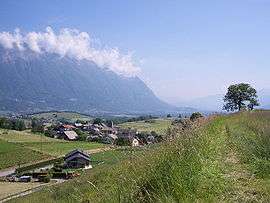
A general view of Hauteville | ||
| ||
 Hauteville | ||
|
Location within Auvergne-Rhône-Alpes region  Hauteville | ||
| Coordinates: 45°31′50″N 6°10′24″E / 45.5306°N 6.1733°ECoordinates: 45°31′50″N 6°10′24″E / 45.5306°N 6.1733°E | ||
| Country | France | |
| Region | Auvergne-Rhône-Alpes | |
| Department | Savoie | |
| Arrondissement | Chambéry | |
| Canton | Chamoux-sur-Gelon | |
| Intercommunality | Gelon et Coisin | |
| Government | ||
| • Mayor (2008–2014) | Marc Girard | |
| Area1 | 2.45 km2 (0.95 sq mi) | |
| Population (2006)2 | 297 | |
| • Density | 120/km2 (310/sq mi) | |
| Time zone | CET (UTC+1) | |
| • Summer (DST) | CEST (UTC+2) | |
| INSEE/Postal code | 73133 / 73390 | |
| Elevation | 300–640 m (980–2,100 ft) | |
|
1 French Land Register data, which excludes lakes, ponds, glaciers > 1 km² (0.386 sq mi or 247 acres) and river estuaries. 2 Population without double counting: residents of multiple communes (e.g., students and military personnel) only counted once. | ||
.svg.png)
Hauteville is a commune in the Savoie department in the Auvergne-Rhône-Alpes region in south-eastern France.
See also
References
| Wikimedia Commons has media related to Hauteville (Savoie). |
This article is issued from Wikipedia - version of the 10/28/2016. The text is available under the Creative Commons Attribution/Share Alike but additional terms may apply for the media files.