Warren County, Virginia
| Warren County, Virginia | ||
|---|---|---|
|
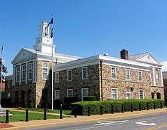
Warren County Courthouse in Front Royal, Virginia | ||
| ||
 Location in the U.S. state of Virginia | ||
 Virginia's location in the U.S. | ||
| Founded | 1836 | |
| Named for | Joseph Warren | |
| Seat | Front Royal | |
| Largest town | Front Royal | |
| Area | ||
| • Total | 217 sq mi (562 km2) | |
| • Land | 213 sq mi (552 km2) | |
| • Water | 3.3 sq mi (9 km2), 1.5% | |
| Population (est.) | ||
| • (2015) | 39,083 | |
| • Density | 180/sq mi (69/km²) | |
| Congressional district | 6th | |
| Time zone | Eastern: UTC-5/-4 | |
| Website |
www | |

Warren County is a county located in the Commonwealth of Virginia. As of the 2010 census, the population was 37,575.[1] Its county seat is Front Royal.[2]
Warren County is included in the Washington-Arlington-Alexandria, DC-VA-MD-WV Metropolitan Statistical Area.
History
Warren County was established in 1836 from Frederick and Shenandoah counties. The county is named for Joseph Warren. During the Civil War the Battle of Front Royal took place in the county on May 23, 1862.
Geography
According to the U.S. Census Bureau, the county has a total area of 217 square miles (560 km2), of which 213 square miles (550 km2) is land and 3.3 square miles (8.5 km2) (1.5%) is water.[3]
Adjacent counties
- Frederick County, Virginia – north
- Clarke County, Virginia – northeast
- Fauquier County, Virginia – east
- Rappahannock County, Virginia – southeast
- Page County, Virginia – southwest
- Shenandoah County, Virginia – west
National protected areas
- Cedar Creek and Belle Grove National Historical Park (part)
- George Washington National Forest (part)
- Shenandoah National Park (part)
Demographics
| Historical population | |||
|---|---|---|---|
| Census | Pop. | %± | |
| 1840 | 5,627 | — | |
| 1850 | 6,607 | 17.4% | |
| 1860 | 6,442 | −2.5% | |
| 1870 | 5,716 | −11.3% | |
| 1880 | 7,399 | 29.4% | |
| 1890 | 8,280 | 11.9% | |
| 1900 | 8,837 | 6.7% | |
| 1910 | 8,589 | −2.8% | |
| 1920 | 8,852 | 3.1% | |
| 1930 | 8,340 | −5.8% | |
| 1940 | 11,352 | 36.1% | |
| 1950 | 14,801 | 30.4% | |
| 1960 | 14,655 | −1.0% | |
| 1970 | 15,301 | 4.4% | |
| 1980 | 21,200 | 38.6% | |
| 1990 | 26,142 | 23.3% | |
| 2000 | 31,584 | 20.8% | |
| 2010 | 37,575 | 19.0% | |
| Est. 2015 | 39,083 | [4] | 4.0% |
| U.S. Decennial Census[5] 1790–1960[6] 1900–1990[7] 1990–2000[8] 2010–2012[1] | |||
As of the census[9] of 2000, there were 31,584 people, 12,087 households, and 8,521 families residing in the county. The population density was 148 people per square mile (57/km²). There were 13,299 housing units at an average density of 62 per square mile (24/km²). The demographics of the county is (2000) 92.71% White, 4.83% Black or African American, 0.27% Native American, 0.43% Asian, 0.02% Pacific Islander, 0.46% from other races, and 1.29% from two or more races. 1.56% of the population were Hispanic or Latino of any race.
There were 12,087 households out of which 32.80% had children under the age of 18 living with them, 55.60% were married couples living together, 10.00% had a female householder with no husband present, and 29.50% were non-families. 24.00% of all households were made up of individuals and 8.80% had someone living alone who was 65 years of age or older. The average household size was 2.57 and the average family size was 3.04.
In the county, the population was spread out with 25.60% under the age of 18, 7.60% from 18 to 24, 30.60% from 25 to 44, 23.90% from 45 to 64, and 12.30% who were 65 years of age or older. The median age was 37 years. For every 100 females there were 96.70 males. For every 100 females age 18 and over, there were 94.90 males.
The median income for a household in the county was $42,422, and the median income for a family was $50,487. Males had a median income of $37,182 versus $25,506 for females. The per capita income for the county was $19,841. About 6.00% of families and 8.50% of the population were below the poverty line, including 8.70% of those under age 18 and 10.40% of those age 65 or over.
Transportation
- Front Royal Area Transit (FRAT) provides weekday transit for the town of Front Royal.
- Page County Transit The People Movers provides weekday transit for the town of Luray and weekday service between Luray and Front Royal.
Major highways
Education
Colleges
Preparatory school
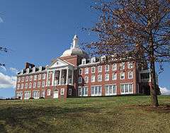
- Randolph-Macon Academy (6-12)
Public K-12 Schools
- Warren County High School (Virginia) (8–12)
- Skyline High School (8–12)
- Warren County Middle School (6–7)
- A.S. Rhodes Elementary School (K-5)
- E. Wilson Morrison Elementary School (K-5)
- Hilda J. Barbour Elementary School (K-5)
- Leslie Fox Keyser Elementary School (K-5)
- Ressie Jefferies Elementary School (K-5)
Communities
Town
- Front Royal (county seat)
Unincorporated communities
|
|
Notable residents
- Thomas M. Allen, born in Warren County, clergyman and university official in Missouri
- Thomas Ashby, born in Warren County, physician and Maryland state legislator
See also
| Wikimedia Commons has media related to Warren County, Virginia. |
References
- 1 2 "State & County QuickFacts". United States Census Bureau. Retrieved January 5, 2014.
- ↑ "Find a County". National Association of Counties. Retrieved 2011-06-07.
- ↑ "US Gazetteer files: 2010, 2000, and 1990". United States Census Bureau. 2011-02-12. Retrieved 2011-04-23.
- ↑ "County Totals Dataset: Population, Population Change and Estimated Components of Population Change: April 1, 2010 to July 1, 2015". Retrieved July 2, 2016.
- ↑ "U.S. Decennial Census". United States Census Bureau. Retrieved January 5, 2014.
- ↑ "Historical Census Browser". University of Virginia Library. Retrieved January 5, 2014.
- ↑ "Population of Counties by Decennial Census: 1900 to 1990". United States Census Bureau. Retrieved January 5, 2014.
- ↑ "Census 2000 PHC-T-4. Ranking Tables for Counties: 1990 and 2000" (PDF). United States Census Bureau. Retrieved January 5, 2014.
- ↑ "American FactFinder". United States Census Bureau. Retrieved 2011-05-14.
 |
Frederick County | Clarke County | | |
| Shenandoah County | |
Fauquier County | ||
| ||||
| | ||||
| Rappahannock County | Page County |
Municipalities and communities of Warren County, Virginia, United States | ||
|---|---|---|
| Town | | |
| CDPs | ||
| Unincorporated communities |
| |
| Footnotes | ‡This populated place also has portions in an adjacent county or counties | |
| Principal cities |
| |||||||||||
|---|---|---|---|---|---|---|---|---|---|---|---|---|
| Counties and county equivalents* |
| |||||||||||
The District of Columbia itself, and Virginia's incorporated cities, are county equivalents. Virginia's incorporated cities are listed under their surrounding county. The incorporated cities bordering more than one county (Alexandria, Falls Church and Fredericksburg) are listed under the county they were part of before incorporation as a city. | ||||||||||||


Coordinates: 38°55′N 78°13′W / 38.91°N 78.21°W