Bryson City, North Carolina
| Bryson City, North Carolina | |
|---|---|
| Town | |
 | |
 Bryson City, North Carolina Location within the state of North Carolina | |
| Coordinates: 35°25′37″N 83°26′52″W / 35.42694°N 83.44778°WCoordinates: 35°25′37″N 83°26′52″W / 35.42694°N 83.44778°W | |
| Country | United States |
| State | North Carolina |
| County | Swain |
| Township | Charleston |
| Area | |
| • Total | 2.2 sq mi (5.8 km2) |
| • Land | 2.1 sq mi (5.5 km2) |
| • Water | 0.1 sq mi (0.3 km2) |
| Elevation | 1,752 ft (534 m) |
| Population (2010) | |
| • Total | 1,424 |
| • Density | 663.5/sq mi (256.2/km2) |
| Time zone | Eastern (EST) (UTC-5) |
| • Summer (DST) | EDT (UTC-4) |
| ZIP code | 28713 |
| Area code(s) | 828 |
| FIPS code | 37-08480[1] |
| GNIS feature ID | 1019348[2] |
| Website | http://www.brysoncitync.gov/ |
Bryson City is a town in Swain County, North Carolina in the United States. The population was 1,424 as of the 2010 Census.[3] It is the county seat of Swain County.[4]
Geography
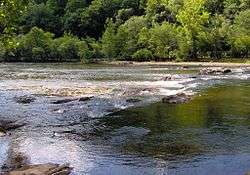
Bryson City is located at 35°25′37″N 83°26′52″W / 35.42694°N 83.44778°W (35.426982, -83.447681),[5] just west of the confluence of the Tuckasegee River, which flows westward from its source in the mountains to the east, and Deep Creek, which flows south from its source near Newfound Gap in the Great Smoky Mountains. After passing through Bryson City and flowing around the Bryson City Island Park, the Tuckasegee flows southwestward for another 12 miles (19 km) before emptying into the Little Tennessee River. Fontana Lake, an impoundment of the Little Tennessee, covers the lower 11 miles (18 km) of the Tuckasegee.
The town is surrounded on all sides by mountains. The Great Smoky Mountains rise to the north, the Cowee Mountains rise to the south, and the Plott Balsams rise to the east. The boundary of the Nantahala National Forest passes just south of the city, and the boundary of the Great Smoky Mountains National Park passes just to the north. The Qualla Boundary, which comprises the bulk of the reservation of the Eastern Band of Cherokee Indians, dominates the area to the east.
Bryson City is centered around the junction of Everett Street and Main Street. Main Street is part of U.S. Route 19, which connects Bryson City to Cherokee to the northeast and Murphy to the southwest.
According to the United States Census Bureau, the town has a total area of 2.2 square miles (5.7 km2), of which, 2.1 square miles (5.4 km2) of it is land and 0.1 square miles (0.26 km2) of it (5.33%) is water.
Demographics
| Historical population | |||
|---|---|---|---|
| Census | Pop. | %± | |
| 1900 | 417 | — | |
| 1910 | 612 | 46.8% | |
| 1920 | 882 | 44.1% | |
| 1930 | 1,806 | 104.8% | |
| 1940 | 1,612 | −10.7% | |
| 1950 | 1,499 | −7.0% | |
| 1960 | 1,084 | −27.7% | |
| 1970 | 1,290 | 19.0% | |
| 1980 | 1,556 | 20.6% | |
| 1990 | 1,145 | −26.4% | |
| 2000 | 1,411 | 23.2% | |
| 2010 | 1,424 | 0.9% | |
| Est. 2015 | 1,458 | [6] | 2.4% |
As of the census[1] of 2000, there were 1,411 people (1,353 in 2009), 588 households and 323 families residing in the town.[8] The population density was 663.5 people per square mile (255.8/km²). There were 713 housing units at an average density of 335.3 per square mile (129.2/km²). The racial makeup of the town was 90.93% White, 1.98% African American, 4.96% Native American, 0.35% Asian, 0.64% from other races, and 1.13% from two or more races. Hispanic or Latino of any race were 1.70% of the population.
There were 588 households out of which 21.8% had children under the age of 18 living with them, 38.1% were married couples living together, 12.8% had a female householder with no husband present, and 44.9% were non-families. 41.3% of all households were made up of individuals and 20.7% had someone living alone who was 65 years of age or older. The average household size was 2.09 and the average family size was 2.78.
In the town the population was spread out with 17.6% under the age of 18, 5.9% from 18 to 24, 24.9% from 25 to 44, 24.5% from 45 to 64, and 27.1% who were 65 years of age or older. The median age was 46 years. For every 100 females there were 77.9 males. For every 100 females age 18 and over, there were 78.2 males.
The median income for a household in the town was $23,232, and the median income for a family was $31,875. Males had a median income of $26,528 versus $19,833 for females. The per capita income for the town was $14,446. About 14.8% of families and 19.2% of the population were below the poverty line, including 25.4% of those under age 18 and 21.0% of those age 65 or over.
History
Native Americans have been living and hunting in the vicinity of what is now Bryson City for nearly 14,000 years.[9] The village of Kituhwa, which the Cherokee believed to be their oldest village, was located along the Tuckasegee immediately upstream from Bryson City. In 1567, an orata (minor chief) from Kituhwa is believed to have met with Spanish explorer Juan Pardo in the French Broad Valley to the north.[10] Although Kituhwa was burned by American soldiers in 1776, the Cherokee continued to hold annual ceremonial dances at the site throughout the 19th century.[11]

Around 1818, a Cherokee chief known as Big Bear received a 640-acre (2.6 km2) reservation of land immediately west of the confluence of Deep Creek and the Tuckasegee River, which included most of what is now Bryson City. Big Bear sold part of his reservation to Darling Belk in 1819 and another part to John B. Love in 1824. Throughout the 1830s, Belk's heirs and Love fought an extended legal battle over control of the Big Bear reservation, with Love finally prevailing in 1840. The following year, Love sold part of the land to James and Diana Shular. The Shulars, in turn, sold off parts of their land to Colonel Thaddeus Bryson and merchant Alfred Cline. A small hamlet known as Bear Springs developed amidst what was once Big Bear's reservation.[11]
Swain County was formed from parts of Jackson County and Macon County in 1871, and the new commissioners first met at Cline's store (now operated by Cline's widow, Lucy Ann Raby Cline) at Bear Springs. Lucy Ann Raby Cline agreed to sell several lots of her land for the formation of a county seat for the new county. The county seat, initially known as Charleston, was laid out in a T-shape formed by what is now Main Street and Everett Street (the latter street was named for the county's first sheriff, Epp Everett). The first Swain County Courthouse was completed in 1874.[12] In 1872, shortly after the completion of the new jail, a legendary jailbreak occurred at the Swain County jail when a gang led by Harvey Cooper stormed the jail and freed Tom Colvert, whom they deemed unjustly imprisoned for killing a rival at a saloon in Robbinsville.[13]
In 1889, the people of Charleston changed the city's name to "Bryson City" to acknowledge the many services rendered to the city by Thaddeus Bryson and to eliminate the confusion brought about by sharing a name with Charleston, South Carolina. The Western North Carolina Railroad laid tracks through Bryson City in 1884, greatly easing transportation to the previously-remote area. The Bryson City Bank opened in 1904 and the current Swain County Courthouse was completed in 1908.[12]

The Great Smoky Mountains National Park, which opened in 1933, provides a major source of revenue for Swain County. Horace Kephart, an author and outdoors enthusiast who operated out of Bryson City for several years, was a key early proponent for the creation of the park.[14] The Deep Creek section of the park, which is immediately north of Bryson City, is home to a large campground and multiple trailheads. The park's main eastern entrance is located just a few miles east of Bryson City at Cherokee. Cherokee is also home to the southern terminus of the Blue Ridge Parkway.
The completion of Fontana Dam in 1944 inundated the only highway connecting Bryson City with the remote area of the Smokies known as the North Shore. The U.S. government began constructing a new highway in 1948, although work on this highway (known as Lakeview Drive) was embarrassingly slow. By 1972, only 7 miles (11 km) had been completed. Environmental and financial issues stalled the project, and the road became known to locals as "The Road to Nowhere". In 2007, the National Park Service deemed the road's construction to be in violation of the Great Smoky Mountains National Park's general management plan, and began working with Swain County to find an alternative.[15]
The increasing popularity of the automobile led to a decline in railroad transportation, and Southern Railway (who had replaced the Western North Carolina Railroad) dropped passenger service in 1948. After Norfolk Southern ended freight traffic on the railroad in 1985, the state of North Carolina purchased the tracks. In 1988, a scenic line known as the Great Smoky Mountains Railroad was established with its depot and departure point in Bryson City.[16]
In Cormac McCarthy's 1979 novel, Suttree, the title character winds up in Bryson City after wandering over the mountains from Gatlinburg. He is kicked out of a restaurant for swearing at a waitress and is refused service at a bar before buying a bus ticket back to Knoxville.[17]
Government
There is a federal building and federal courthouse in Bryson City, located at 50 Main Street. The courthouse is in the jurisdiction of the United States District Court for the Western District of North Carolina.
Notable people
- Horace Kephart - Outdoorsman and author
- Franklin Paul Rogers - influential tattoo artist
- Heath Shuler - Former quarterback for the University of Tennessee (1990-'93), New Orleans Saints, Oakland Raiders, and Washington Redskins. He is also a former congressman who represented North Carolina's 11th congressional district from 2007 to 2013.
- Red Smiley - Famous bluegrass musician, part of the duo Reno and Smiley, lived in Bryson City as a young man while his father served as the Swain County School System Superintendent, before starting his career. He is now buried in the DeHart Cemetery in the Jackson Line Community.
- The Inspirations, one of Southern Gospel Music's leading and most enduring quartets, was founded in Bryson City in 1964, and still makes its home there today.[18]
References
| Wikimedia Commons has media related to Bryson City, North Carolina. |
- 1 2 "American FactFinder". United States Census Bureau. Archived from the original on 2013-09-11. Retrieved 2008-01-31.
- ↑ "US Board on Geographic Names". United States Geological Survey. 2007-10-25. Retrieved 2008-01-31.
- ↑ "Bryson City, North Carolina (NC 28713) profile: population, maps, real estate, averages, homes, statistics, relocation, travel, jobs, hospitals, schools, crime, moving, houses, news, sex offenders". City-data.com. Retrieved 2012-05-14.
- ↑ "Find a County". National Association of Counties. Archived from the original on 2011-05-31. Retrieved 2011-06-07.
- ↑ "US Gazetteer files: 2010, 2000, and 1990". United States Census Bureau. 2011-02-12. Retrieved 2011-04-23.
- ↑ "Annual Estimates of the Resident Population for Incorporated Places: April 1, 2010 to July 1, 2015". Retrieved July 2, 2016.
- ↑ "Census of Population and Housing". Census.gov. Archived from the original on May 11, 2015. Retrieved June 4, 2015.
- ↑ http://censtats.census.gov/data/NC/1603708480.pdf
- ↑ Beadle, Michael (May 24, 2006). "Remembering the Mother Town". Smokymountainnews.com. Retrieved August 18, 2008.
- ↑ Charles Hudson, The Juan Pardo Expeditions: Explorations of the Carolinas and Tennessee, 1566-1568 (Tuscaloosa, Ala.: University of Alabama Press, 2005), 97.
- 1 2 "History of Bryson City and Swain County, North Carolina". Brysoncitync.info. Retrieved August 18, 2008.
- 1 2 "History of Bryson City and Swain County, North Carolina". Brysoncitync.info. Retrieved August 18, 2008.
- ↑ "History of Bryson City and Swain County, North Carolina". Brysoncitync.info. Retrieved August 18, 2008.
- ↑ "History of Bryson City and Swain County, North Carolina". Brysoncitync.info. Retrieved August 18, 2008.
- ↑ "Final Environmental Impact Statement — North Shore Road". The National Park Service, et al. Northshoreroad.info. September 2007. Archived from the original on May 9, 2008. Retrieved November 9, 2007.
- ↑ "About the Great Smoky Mountain Railroad". Gsmr.com. Retrieved August 18, 2008.
- ↑ Cormac McCarthy, Suttree (Vintage, 1992), pp. 291-293.
- ↑ "Inspirations Press Info". Theinspirations.com. 2009-02-28. Retrieved 2012-05-14.
External links
Municipalities and communities of Swain County, North Carolina, United States | ||
|---|---|---|
| Town | 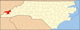 | |
| CDP | ||
| Unincorporated communities | ||
| Footnotes | ‡This populated place also has portions in an adjacent county or counties | |