Buchanan Township, Atchison County, Missouri
| Buchanan Township | |
|---|---|
| Township | |
 | |
| Coordinates: 40°32′26″N 095°37′16″W / 40.54056°N 95.62111°WCoordinates: 40°32′26″N 095°37′16″W / 40.54056°N 95.62111°W | |
| Country | United States |
| State | Missouri |
| County | Atchison |
| Area | |
| • Total | 42.02 sq mi (108.84 km2) |
| • Land | 41.25 sq mi (106.84 km2) |
| • Water | 0.77 sq mi (2.00 km2) 1.84% |
| Elevation[1] | 909 ft (277 m) |
| Population (2010) | |
| • Total | 83 |
| • Density | 2/sq mi (0.8/km2) |
| FIPS code | 29-09244[2] |
| GNIS feature ID | 0766231 |
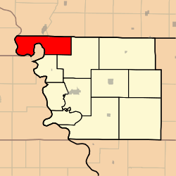
Buchanan Township is one of eleven townships in Atchison County, Missouri, United States. As of the 2010 census, its population was 83.[3] The northwest corner of the township is the northwest corner of the entire state.
Buchanan Township was established in 1858, and named after James Buchanan, the 15th President of the United States.[4]
Geography
Buchanan Township covers an area of 41.7 square miles (108.0 km2) and contains no incorporated settlements. Buchanan Township has one cemetery: Union. Greys Lake is within this township.
References
- ↑ "US Board on Geographic Names". United States Geological Survey. 2007-10-25. Retrieved 2008-01-31.
- ↑ "American FactFinder". United States Census Bureau. Archived from the original on 2013-09-11. Retrieved 2008-01-31.
- ↑ "Geographic Identifiers: 2010 Demographic Profile Data (G001): Buchanan township, Atchison County, Missouri". U.S. Census Bureau, American Factfinder. Retrieved June 25, 2013.
- ↑ "Atchison County Place Names, 1928-1945 (archived)". The State Historical Society of Missouri. Archived from the original on 24 June 2016. Retrieved 30 August 2016.
External links
Municipalities and communities of Atchison County, Missouri, United States | ||
|---|---|---|
| Cities | 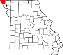 | |
| Village | ||
| Townships | ||
| CDPs | ||
| Unincorporated communities | ||
| Ghost towns | ||
This article is issued from Wikipedia - version of the 11/10/2016. The text is available under the Creative Commons Attribution/Share Alike but additional terms may apply for the media files.